


Serviços Personalizados
Journal
Artigo
 Inglês (pdf)
 Artigo em XML
 Referências do artigo
 Enviar este artigo por email
Indicadores
-
 Citado por SciELO
 -
 Acessos
Links relacionados
-
 Similares em
SciELO
Similares em
SciELO
Compartilhar

 Permalink
Revista de Gestão Costeira Integrada
versão On-line ISSN 1646-8872
RGCI vol.15 no.4 Lisboa dez. 2015
https://doi.org/10.5894/rgci553
ARTICLE / ARTIGO
Long-term morphological evolution of urban pocket beaches in Montevideo (Uruguay): impacts of coastal interventions and links to climate forcing*
Evolução morfológica de longo prazo das praias urbanas de bolso de Montevidéu (Uruguai): impactos das intervenções costeiras e relações com as forçantes climáticas
Ofelia Gutiérrez @, 1; Daniel Panarioa1; Gustavo J. Nagy2; Gustavo Piñeiro3; Carlos Montes4
@Corresponding author to whom correspondence should be addressed.
1Universidad de la República, Facultad de Ciencias, Instituto de Ecología y Ciencias Ambientales (IECA), UNCIEP, Montevideo, Uruguay. e-mails: Gutiérrez <oguti@fcien.edu.uy>; Panario <panari@fcien.edu.uy> <daniel.panario@gmail.com>
2Universidad de la República, Facultad de Ciencias, Instituto de Ecología y Ciencias Ambientales (IECA), Grupo de Cambio Ambiental y Gestión Costero Marina, Oceanografía y Ecología Marina, Montevideo, Uruguay. e-mail: <gnagy@fcien.edu.uy>, <gustavo.nagy56@gmail.com>
3Universidad de la República, Facultad de Ciencias, Instituto de Ciencias Geológicas, Departamento de Evolución de Cuencas, Montevideo, Uruguay. e-mail:<gaitapi@fcien.edu.uy>, <estudiosgeologicos@gmail.com>
4Universidad Autónoma de Madrid, Facultad de Ciencias, Departamento de Ecología, Madrid, España. e-mail: <carlos.montes@uam.es>
ABSTRACT
Two pocket beaches, Ramírez and Pocitos (Montevideo, Uruguay) are analyzed to assessing their evolution (erosion/accretion) associated with human interventions and climatic forcings from 1927-2008. A multitemporal study was conducted using GIS, long series of aerial photos, satellite imagery, survey of historical background, and statistical analysis. Qualitative indicators of the stability of the beach area are proposed. The relevance of this methodology is analyzed on beaches whose fluctuations tend to mask their long-term evolution. Both beaches remain relatively stable but fluctuating since 1927, with slight loss of surface, especially in Ramírez. The influence of the following factors is discussed: i) human interventions; ii) ENSO events; iii) storm surges; iv) changes in beach area according to the Bruun rule and rising sea level in Montevideo. Although the four of them appear to have acted in different periods, the evidence is not conclusive regarding their relative quantitative importance. This article highlights the importance of using long series of remote sensing and historical analysis to interpret processes linked to inertia of the past in environments that have been modified from longstanding. The trend analysis of these two urban pocket beaches allows to infer that their resilience has not been affected yet, which would allow them to face not extreme climatic stressors. For the purpose of better management it is recommended to: i) conduct continuous monitoring; ii) minimize the actions of mechanized cleaning and sand losses by leakage or removal; iii) implement the reconstruction of natural structures such as primary dunes; and iv) apply the methodology explained in this paper in other Montevideo urban beaches to better understand the climate forcings.
Keywords: Remote sensing, sandy beaches, coastline proxy records, erosion/accretion, omega parameter, coastal management.
RESUMO
Duas praias de bolso, Ramírez e Pocitos (Montevideo, Uruguai) foram analisados para avaliar a sua evolução (erosão / acreção) associado a intervenções humanas e forçantes climáticas durante o período 1927-2008. Para tal, desenvolveu-se estudo multitemporal utilizando GIS, uma série longa de fotos aéreas, imagens de satélite, exame dos antecedentes históricos, e análise estatística. São propostos indicadores qualitativos da estabilidade da praia. A relevância da metodologia utilizada é analisada em praias cujas variações tendem a mascarar a sua evolução a longo prazo. Ambas as praias permaneceram, desde 1927, relativamente estáveis, embora com variações e ligeira perda de superfície, especialmente a praia de Ramirez. Neste artigo é discutida a influência dos seguintes fatores: i) intervenções humanas; ii) eventos de El Niño; iii) temporais; iv) mudanças na praia de acordo com a regra Bruun e elevação do nível do mar, em Montevidéu. Embora os quatro fatores referidos tenham atuado em diferentes períodos, as evidências não são conclusivas quanto à sua importância quantitativa relativa. O artigo destaca a importância da utilização de séries longas de sensoriamento remoto e da análise histórica na interpretação dos processos ligados à inércia do passado em ambientes que foram modificados desde há muito. A análise de tendências destas duas praias urbanas de bolso permite inferir que a sua resistência ainda não foi afetada, o que lhes permitiria enfrentar os estressores climáticos extremos. Com o objetivo de conseguir uma melhor gestão, recomenda-se: i) realizar monitoramento contínuo; ii) minimizar as ações de limpeza mecanizada e as perdas de areia por vazamento ou remoção; iii) implementar a reconstrução de estruturas naturais, como dunas primárias; e iv) aplicar a metodologia apresentada neste artigo noutras praias urbanas de Montevidéu para compreender melhor as forçantes climáticas.
Palavras-chave: sensoriamento remoto, praias de areia, indicadores da linha de costa, erosão / acreção, parâmetros omega, gestão costeira.
1. Introduction
Beach erosion is a serious world-wide problem; according to Bird (1985), at least 70% of sandy beaches are recessional. From the 1990s, this finding has driven to the achievement of long-term studies, in some countries taking advantage of the existence of high-resolution images (from circa 1930) and cartographic precision surveys (since the late nineteenth century). The relationship between trends and natural or induced events has allowed to understand the processes involved in each case, and develop baseline scenarios (i.e., Dias et al., 2000; Ferreira et al., 2006; Dolch, 2010; Baptista et al., 2011; Klemas, 2011; Pilkey et al., 2011; Sato et al., 2011; Almeida, 2012; Freitas & Dias, 2012; Echevarría et al., 2013; Ribeiro et al., 2013; Splinter et al., 2013).
Achieving integrated coastal management of beaches is a global aspiration because of their vulnerability, ecological and heritage value, and the mounting pressure on the ecosystem driven by the steady increase in the population settled in coastal areas over the past few decades (Brown & McLachlan, 2002).
Modification of coastal ecosystems and increased pressures on the resources that sustain their structure and function, should be seen as a global problem, as these ecosystems are of fundamental importance, providing various goods and services that directly contribute to socio-economic development defined by the Millennium Ecosystem Assessment (2005) as the direct or indirect benefits that humans obtain from ecosystems.
Thus, healthy and functional beaches provide various ecosystem services, which can be grouped into three main functions: provisioning, regulating and cultural. However, these ecosystems have been modified and adapted by direct or indirect human interventions, which ultimately affect the system's capabilities to provide these services and therefore support social welfare.
In this article, the concept of ecosystem services is the framework of our research and hypotheses. Therefore, the focus is on the surface of the beach and not only in the behavior of the coastline.
Despite the interest in beach conservation, management successes have been few, and since the 1980s widespread erosion of beaches (Bird, 1985) has increased due to Land Use Change (civil construction, real estate pressure, aggregate extraction), or simply by gradual depletion of circulating sand. These changes are enhanced by the effects of climate change such as rising sea levels, and increased frequency and intensity of storms (Nordstrom, 2004).
Causes of successive failures are multiple, but two can be highlighted: firstly the lack of knowledge of the long-term dynamics of each particular beach (Carter, 1988) and secondly, the multiplicity of jurisdictions and interests acting in this complex system. In Uruguay in particular, during the twentieth century, human interventions have changed the coastal morphology and dynamics, while in parallel the beaches began to show erosion and retreat of the coastline was observed (Panario & Gutiérrez, 2006).
According to Dias et al. (2012) in order to adopt corrective measures and an effective coastal zone management, it is essential to understand the current situation.
This analysis focuses on two beaches, Ramírez and Pocitos at Montevideo, the capital city of Uruguay and home to a million and a half inhabitants. Both beaches have economic importance as areas for recreation, tourism, culture, and as iconic symbols. The intensity of use in both beaches led to a loss of their natural structure, leaving only sand surfaces bordered by a waterfront promenade, called “Rambla Costanera" or simply “La Rambla”, which is the most popular ride in the city.
Because of their importance, these beaches have been certified for bathing, according to ISO 14001 standards by the municipal government of Montevideo (IdeM). These standards require the implementation of a continuous improvement process. Therefore, a retrospective analysis was performed in order to: i) depict the historical evolution; ii) project trends of erosion-accretion, taking advantage of the existence of a large number of remote sensing images; and iii) establish management recommendations.
The trends and drivers of the historical evolution of the beaches are analyzed from the extensive series of vertical aerial photographs since 1927, old maps, chronicles of physical and climatic databases over time using statistical indicators and various indicators of changes in the coastline. So the relevance of the method of long multi-temporal analysis (1927-2008) is tested on beaches whose fluctuations tend to mask long-term trends.
2. Study area and characterization
2.1. The Beaches
Ramírez and Pocitos are two urban pocket beaches located opposite each other, on a headland. They are oriented NNE-SSW, the former to the east side and the latter to the west side of the bow (Figure 1). This coast is a microtidal environment (amplitude less than 50 cm, Verocai et al., 2015), wave-dominated (significant wave height [Hs]: 0.54 m; wave period [T] 5.66 s) and located in the middle region (brackish waters) of the Río de la Plata river estuary.
Ramírez is a dissipative beach with a convex profile bounded by two headlands (Figure 2), a gentle slope (1.9°) that accentuates to the north end with a maximum of 2.7 degrees between 0.5 and 1.5 m water level amsl (meters above mean sea level reference = 0.91 m), with wet and dry sectors 10-15 and 65 m wide respectively, measured in its middle section, with a coastline of 500 m. As a particular feature, Ramírez exposes more than 100 m of additional beach during ebb, composed of sediments enriched with dense minerals.
Pocitos is also bounded by two headlands (Trouville and Kibón). It is a sandy beach convex toward the berm (Figure 2), with a gentle slope (1.8°), which is accentuated to the north end (2.6° between water levels 0.5 and 1.5 m), concomitant with its northward evolution from a dissipative beach into an intermediate one. This beach has a wet area of 10 to 15 m width at its middle zone and a dry width of 65 m. The coastline is 1,427 m length. Both beaches are bounded by the wall of the waterfront, which is semicircular in Ramírez, and both lack the primary dune. The sediments of Pocitos and Ramírez beaches originate from different sources: estuarine sands and gravels, subrecent autochthonous alluvium, erosion of the crystalline basement debris and bioclastic material (shells). These sediments are partially retransported by runoff, human action in mechanized maintenance, and wind action with sand losses to the mainland (roads).
2.2. Issues and Background
a. Ramírez Beach
Maps by the British Navy (years 1849 and 1883) and the French Navy (1867) indicate that Ramírez was wider and extended to the NW about 800 meters (about twice as long as by 2008), and seaward about 200 meters (twice the width remaining in its current location) (Figure 3). The survey of the IdeM (25/07/2007 manzanas.dwg, file) included cadastral references that are now located under water on this beach.
Ramírez beach was probably used as one of the primary sources of sand for construction of Old Montevideo and later the surrounding neighborhoods, as was subsequently Pocitos, once the expansion of the city reached its vicinity. In particular, in the early 1960s, according to MTOP/PNUD/UNESCO (1979) Ramírez was used as a source of sand to make an attempt to nourishment of Pocitos beaches.
Ramírez suffered significant erosion before 1927, leaving a surface enriched with sandy heavy minerals, which explains the slope of the beach. An area located to the NW was covered by the construction of the southern waterfront promenade, and the fill material was sand dredged from the offshore vicinities, which reduced the stock of nearshore sediment available in this area.
In photographic records of 1927 and 1929, a retreat of 200 meters had already occurred. The chart of the Military Geographic Service (published in 1929) based on surveys conducted in 1920, recorded this shoreline retreat with a configuration similar to the present. In turn, the image of 1927 presumably reflects the effect of extreme storm surges that occurred in 1923 and 1924, a feature clearly documented in the existing iconography. The storm surge of July 1923 was the strongest ever recorded since the beginning of measurements in 1898 (Verocai et al., 2015) with a water level of 3.39 m amsl and an estimated return period of 821 years (MTOP/PNUD/UNESCO, 1979). The storm surge of January 1924 reached a water level of 2.19 m amsl (MTOP/PNUD/UNESCO, 1979; modified from the database of the Directorate of Oceanography, Meteorology and Hydrography of the Navy-SOHMA). The 1923 storm had winds of over 150 km/hour. This storm devastated the south coast of the city, which was reported by the press: "All the (South) Rambla has disappeared as well as the resorts of Ramírez and Pocitos" (El País Newspaper the day after the storm surge).
The cartographic documentation hiatus between 1886 and 1920 has not allowed generating a reconstruction of the rhythms of intense erosion process verified over that period, or specifying their causes.
The existence of a dune field is reflected in old place names (e.g., Road to the Dunes: “Camino a los Médanos”). The recirculation of this sand dune field originated from the mouths of the two creeks that existed on this beach. This recirculation was stopped early (late nineteenth century), when the waterfront promenade “La Rambla” was built, encircling the arc of the beach. This first layout of the waterfront at Ramírez beach, confined the beach to a well constrained arc. Such intervention modified the beach, dividing what was originally a functional unit, consisting of an arc of beach with the presence of a small tombolo near his its southern end. Subsequently, the northwest beach portion was filled, with the promenade (public walk), which was built gaining land to sea.
The arc of beach on the outside did not encompass the shape as was the original natural setting, because the new beach had a greater curvature. Since then the storm waves concentrate at both ends.
b. Pocitos Beach
The geomorphological changes documented in Pocitos beach have also been dramatic. Near the mid-nineteenth century there were dunes up to 10 meters high, and a beach prism several meters higher than the current situation (Ros, 1923; García-Moyano, 1969; Barrios-Pintos, 1971). These dunes were removed along with beach sand, to be used for construction (Ros, 1923; García-Moyano, 1969). This activity severely affected the amount for the beach sediment budget, to the extent that the foundations of houses were seen during an extreme low water event in the early twentieth century (Ros, 1923).
At the beginning of the twentieth century, three creeks flowed into this beach, but when the southern stretch of the waterfront was built in 1912, the creeks were encased and diverted. This original waterfront protruded into a section of beach and divided it into two sections (See Supporting Information SI.1c). At that time a large building (“Hotel de los Pocitos”) was built on the beach, but was demolished in 1935, after being affected by the extreme storm surge in 1923. The 1927 photo shows only the Pocitos creek (See SI.1b), which in 1945 (See SI.1a) had also been encased and widened, cutting the recirculation of sand dune fields through its mouth. By 1950, the layout of “La Rambla” was rectified to its present form, and the surface of dry beach located in the NE sector was artificially extended.
Prior to the construction of “La Rambla”, the beach was wider, from 40 to about 80 meters (based on an accurate survey conducted for the "Sanitation Project of the Pocitos Creek Basin", García, 1908). Also in that time, the prism of the beach was approximately two meters higher than present (Figure 4), whereas the prism now fluctuates around 60 cm thick above a layer of reworked Pleistocene sands. By the time of the photographic record of 1927, it had already occurred a widespread retreat of the coastline (See Supporting Information SI.2).
Despite the importance of beaches in the social imaginary for Uruguay, there is only one systematic study of beaches (MTOP/PNUD/UNESCO, 1979), which includes a reference to Pocitos and the recommendation for a refill of sand, and an article from Saizar (1997) which predicts its evolution using the Bruun’s Rule.
3. Materials and methods
A multi-temporal analysis was undertaken, using remote sensing from 1927-2008, GIS techniques and historical information. A total of 23 and 21 aerial photographic surveys (1927-2008) were analyzed for Ramírez and Pocitos respectively (Table 1), obtained from the archives of the IdeM, the National Directorate of the Environment (DINAMA), the Military Geographic Service (SGM), and Google Earth satellite images. To better understand the long-term morphological changes, maps of the nineteenth and early twentieth centuries were also included, which have acceptable accuracy.
The series of aerial photographs was scanned at 1200 dpi, and the Google Earth images were downloaded in the best possible resolution. ArcGIS 10 was used for georeferencing, which was carried out using a detailed mapping of the wall of the waterfront surrounding both beaches made by the Department of Geomatics of the IdeM. This map was made by orthorectification and checkpoints from differential GPS with submeter relative accuracy, allowing to minimize errors between images. An accuracy of one pixels is assumed for the imaging georeferencing process. The UTM (Universal Transverse Mercator) Zone 21S projection and WGS84 datum was used.
Shorelines were digitized on screen using a constant scale of 1:3000 to standardize the procedure, according to Ciavola et al. (2003), Gutiérrez & Panario (2005) and Armaroli et al. (2006). The landward limit of the beach was defined as the wall of “La Rambla”, as it has historically functioned as the limit of the active littoral zone, defined here as the area where sediment exchanges between the beach and the nearshore occur.
Different proxy records were explored as indicators of coastline (Boak & Turner, 2005) in order to interpret the responses of the system, i.e., i) the previous high tide high water level - PHTH-WL (Boak & Turner, 2005; Moore et al., 2006) and, ii) in order to evaluate the consistency of the results, the wet/dry line or run-up maxima - WDL-RM (Boak & Turner, 2005; Dolan et al., 1978, 1980; Overton et al., 1999). For the studied beaches, and in agreement with Boak & Turner (2005), both lines are clearly distinguishable from the other. The PHTH-WL is identified by the marks left by the tide (i.e. plant debris), and WDL-RM can be distinguished by the wet-dry sand contrast.
Due to the small size of the beaches and the multi-temporal evolution of the accretion and retreat of the coastline, a beach polygon (area) was drawn as proposed by Gutiérrez & Panario (2005) which is defined by each coastline proxy in each of the images and the corresponding landward limit. This procedure allows reducing uncertainty, since the surface is equivalent to infinite transects (method commonly used for these studies), and ultimately, the beach area is the parameter of greatest socio-economic, ecological and management interest.
It was calculated the percentage difference between the largest/smallest area for Ramírez and Pocitos beaches from 1927 to 2008 and their current areas.
An artifact called "landward limits of the beach in 1927" (L27) was used in Pocitos beach, where the landward limit of the beach was defined on the basis of its configuration in 1927, in order to know the trend, regardless of public works that expanded their area (creek diversion and re-alignment of the coast). A second artifact called "landward limits of the beach in 2008" (L08) was used, where the landward limit is the current (2008) spatial configuration.
The analysis included the long-term fluctuations of the beach area, especially the reductions, which were evaluated against freshwater and sea levels increases in the Río de la Plata river estuary produced by the great floods of the rivers Paraná and Uruguay (combined or separated), the time-series of severe storm surges, and the occurrence of El Niño Southern Oscillation (ENSO) El Niño and La Niña anomalies. Data for sea-level and storm surges at Montevideo (brackish waters) and river flow at the middle Río de la Plata river estuary are provided for the studied period (1928-2008) by the Uruguayan Servicio de Oceanografía, Hidrografía y Meteorología de la Armada (SOHMA) and the Argentinean Instituto Nacional del Agua y el Ambiente (INA) respectively.
Mineralogical analysis of the subaerial and subacuatic sediments of Ramírez and Pocitos beaches was conducted. For Ramirez beach the Dean´s dimensionless parameter Ω (Hb / wf . T) was calculated where Hb is the significant wave height, wf is the sediment fall velocity and T is the wave period, applied as proposed by Wright & Short (1984).
A simple regression statistical analysis is performed using R-CRAN statistical (R Core Team, 2013) software to calculate the model parameters of sand surface evolution. The assumption of normality and randomness was previously evaluated (See Supporting Information SI.I and SI.II). The Anderson-Darling test for normality was conducted on the surfaces value series and a run test was applied with PAST 1.96 (Hammer et al., 2001).
The run test analysis is a non-parametric test for values obtained in time sequence to analyze randomness of events. The data set was transformed by subtracting the average, to obtain positive and negative numbers. This test was used because the data are not continuous by nature, since the flights were not planned for the systematic survey of the morphological evolution of beaches and that despite their statistical significance, the small magnitude of the changes could introduce uncertainty about the randomness of trends.
4. Results and discussion
4.1. Evolution of Ramírez beach
To analyze Ramírez beach, the start date was set at the date of the first image available (1927), when the arc of beach was similar to the current one.
Using a first series of 16 images (1927-2007), the evolution of the coastline according to PHTH-WL and WDL-RM indicators showed a weak significant trend of loss of surface (p <0.19) (Figure 5a and 5b). Then, with a second series of 23 images (1927-2008), the analysis was completed (Figure 5c) and, given the similarity of results obtained, WDL-RM was the only one used as the proxy because it was best expressed in the time-series resulting in a tendency to a significant surface loss with p <0.02. Some of the early records were removed (Figure 5d), based on the assumption that the image of 1945 (there are no records between 1927 and 1929) was shaped more like the present form. Before 1927, the most intense storms ever recorded occurred in Montevideo in 1923, and after the image of 1929, a prominent structure was built in the north end that changed the circulation patterns of sand sediment; hence the images of 1927 and 1929 were excluded.
Since 1927, there was an increase in the area of the arc of the beach until 1961 (maximum increase), possibly recovered from the impact of storm surges of 1923 and 1924. Since 1945, the beach has had the current configuration and the evolution of its surface areas shows a highly significant (p <0.001) negative trend (Figure 5d and see Supporting Information SI.III). The randomness of the process was ruled out by the runs test (Figure 6). Descriptive statistics (See SI.IV) for the series of 16 images (1927-2007) was analyzed for the full set of 23 images (1927-2008), and the complete series using post-1945 images. The coefficient of variation (CV = 12.69%) of beach surface areas shows little variability in the data and it is further reduced by removing from the analysis the photos prior to 1945 (CV = 13.24%). From the analysis of the multi-temporal evolution of Ramírez, and depending on the considered period, a decrease in the surface area of 126 m2/year was recorded (from 1945-2008).
Ramírez behaves as a dissipative beach in typical sea conditions because it is characterized by a large area of low slope, surf and spilling breaking waves. However, the Dean´s dimensionless parameter Ω classifies Ramírez as an "intermediate" sandy beach (46cm / [2cm.s x 4.4s] = 5.2). The Ω parameter determines the threshold values or transition from reflective to intermediate or from dissipative to intermediate beach type. Dean (Ω) values “less than 1” are associated with reflective beaches, values between "1 and 6" are intermediate states and those "over 6" are typically dissipative beaches. The apparent contradiction of this result, may explain its relative stability, despite suffering significant losses due to wind transport towards the waterfront.
The convex transverse profile is characteristic of an intermediate beach as established by the parameter Ω. However, the geological control exerted by the shore platform in the surf zone, determined that under normal conditions the beach behaves as dissipative, whereas it behaves as intermediate under storm surge conditions according to its convex profile and the value of Ω. Here, storm surge is defined as an increase in coastal water level caused by the action of wind blowing over the sea surface (wind setup) (DECCW, 2010).
During low water conditions, the coastline of this beach retreats 200 m and exposes an area of abrasion enriched in dense minerals. Therefore, the relative stability of this beach would be supported by a slow recovery of the profile due to sediment transport from the plain of abrasion to the sub-aerial beach. The analysis of the series of images indicates that Ramírez lost a beach area of 5,791.5 m2 (19.7%) from 1927 to 2008. This loss is relatively consistent with the observed 11 cm sea level rise (SLR) at Montevideo in the last 100 years (Bidegain et al., 2005; Magrin et al., 2007; Nagy et al., 2013, 2014a; Verocai et al., 2014), and the consequent reduction of 5,600 m2 obtained by Saizar (1997) applying the Bruun Rule (where the shoreline retreat is equal to the ratio of rising sea level with the tangent of the angle of the beach).
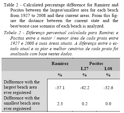
In addition, the difference between the current state and the best/worst case scenario of each beach in the time-series was analyzed. The percentage difference between the largest observed area and its current area was -37.1%, whereas the percentage difference between the smallest observed area and its current area was only 2.3% (Table 2).
Nevertheless, this calculation assumes a linear steady SLR from 1927-2008 which was not been the case; more than half of the observed SLR occurred between 1961-2003 (Nagy et al., 2005). Thus, there is not that good fit between morphological changes and SLR when shorter periods are considered.
4.2. Evolution of Pocitos beach
The analysis of the series of images of Pocitos also begins in 1927, the year of the first photographic record. Unlike Ramírez, Pocitos is oriented eastward which made it less vulnerable to the extreme storm surge in 1923, associated with very strong (> 100 km/hour) and persistent (over 24 hours) Southwest Wind (data collected for the old Servicio Meteorológico del Uruguay). The trend analysis of Pocitos beach was performed using the two artifacts L27 and L08 for the wet/dry line or run-up maxima (WDL-RM) as a proxy of the coastline. The first trend analysis was performed with a series of 15 images from 1927-2007 (Figure 7a and 7b). This series does not show significant changes in the surface area of exposed sand, but for the L27 limit it suggests a marginally significant retracement trend (p = 0.1) (Figure 7a and see Supporting Information SI.Va) of the beach area.
The coefficient of variation (See Supporting Information SI.VI) of beach surface area (series of 15 images: 1927-2007) indicates little variability in the data using L27 (CV = 14.82%), which is further reduced by analyzing the series using L08 as landward limit (CV = 10.21%). To deepen this analysis and confirm or exclude the evidence shown in the previous analysis, a set of 21 images was analyzed from 1927 to 2008. The linear regression trend line indicates a reduction of the beach surface statistically significant (p <0.04) for L27 (See SI.Vc), while the trend is not significant for L08 (See SI.Vd), even indicating a very slight upward trend of beach area (+6 m2/year). This would confirm that the effect of the artificial extensions might have masked the loss of surface area (Figure 7c and 7c). The coefficient of variation of beach surface area (series of 21 images: 1927-2007) indicates little variability in the data (L27 CV = 15.33% and L08 CV = 10.94%) (See SI.VIc and SI.VId).
For both series (15 and 21 images) the runs test does not rule out that the behavior of the advance and retreat of the coastline is of a random type, considering that the value of the test is very close to 0.2 at the edge of the range from which it is considered random (Figure 8a to 8d). The Pocitos dry-beach surface area has increased by 24,000 m2 from 1927 to date due to the expansion work done by the IdeM. Likewise, what was done in Ramírez, assuming that the present configuration of the beach begins in 1954, images of 1927, 1945 and 1949 were removed from the analysis. Then, the beach surface area loss was not statistically significant for L27 and L08. This result would indicate that the surface area of the beach shows a relatively stable system after human intervention began (Figure 7e and 7f).
Such relative stability can have several causes: a) likewise Ramírez, Pocitos also has an abrasion plain located on its southern area (end of Trouville) and much of its current relative stability may be due to slight drift transport from the South to the North, which is reinforced by aeolian transport in the same direction; b) due to its location, the beach is relatively protected from the SW storms, the primary cause of wind-related coastal erosion. Furthermore, fluctuations in the beach match its natural dynamics and/or human intervention, including beach sand filling from Ramírez in the early 1960s.
The descriptive statistics of the series of 18 images from 1954 were also analyzed (See Supporting Information SI.VIe and SI.VIf) when the coast had already been rectified and the beach had a configuration similar to the present. The coefficient of variation of beach surface for L27 decreases (CV = 14.77%) when compared to the test performed with the full set of 21 images, probably because since 1954 the beach has had a conformation similar to the present. However, when the analysis is performed for the series of 18 images using L08 as landward limit (CV = 11.49%), this ratio increases due to increases in the beach surface area and the various modifications made by the local government (IdeM).
Runs test was applied to this series of 18 images (1954 to 2008), and to the two approaches (L27 and L08). The test infers that the advance and retreat of the coastline is random for the level of significance set for both L27 and L08 (Figure 8e and 8f), while the coefficients of variation of the data are kept low for both cases (L27 CV = 14.77% and L08 CV = 11.49%). The figure obtained by applying the Bruun Rule, with the parameter calculated by Saizar (1997) for beaches of Montevideo, is 15,982 m2 in Pocitos which is intermediate between the current (L08), and which would have been observed without human intervention (L27). Also, the estimated regression loss would be negligible for L08 (470 m2) and 10,328 m2 for L27 for 1927-2008 which represents 0.8 and 16.9% respectively.
The loss of sand in Pocitos from 1927-2008 was estimated at 5,257 m2 (8.6% of the surface area) using the L08 artifact, which includes all interventions that increased the surface of the beach; instead, the L27 artifact, that restricts the analysis to the original surface of the beach in 1927, estimated a loss of 25,756 m2 or 42.2% (1927-2008). Despite the relative stability of the coastline, the beach prism suffered a significant reduction from the earliest available detailed map (Figure 4). Such reduction could be explained by the permanent leakage of sand towards the waterfront, from where the sand has been definitively removed whit mechanized cleaning by the IdeM, during the entire analysis period.
However, the percentage difference between the largest observed area compared with the photographical records shows differences of -42% for L27 and -32.6% for L08 suggesting that beyond the statistical results, the current state of the beach shows the highest percentage loss of surface compared to previous states. Moreover, the percentage difference between the lower recorded area compared to the photographical record was 0.2% for L27 and L08 for 0.0%, since 2008 coincides with the lowest record (Table 2).
Therefore, the analysis of the series of 21 images of Pocitos beach from 1927-2008, shows that the dry surface area of this beach has increased, although the same considerations that were made to Ramírez are valid, compounded by the fact that Pocitos beach has in some areas less than 0.60 m of sand thickness. Therefore, the apparent stability of this beach can relate mainly to a continuous "dry beach construction” by the IdeM (Figure 7c and 7e). So, without human intervention Pocitos beach should have suffered a significant reduction.
4.3. Behavior of the ensemble of case studies
For pocket beaches, especially if they are subject to human intervention, a different analysis than the one usually used for a wide beach is required. Pocket beaches may have significant responses to severe climate events; however, trends show spatial changes of small magnitude in the medium term. Ramírez and Pocitos have almost opposite orientations (the former to the West and the latter to the East), different depth gradients and divergent drifts, and although they have a similar mineralogical composition, they are two separate beaches, and independent of the other urban beaches of Montevideo (Figure 1). Therefore, it is particularly important to analyze the causes of the similarities in behavior over the years.
The existence of a relationship between the floods of the Paraná and Uruguay rivers, individually and combined, with the Río de la Plata level at Montevideo was explored, since floods trigger sea level fluctuations (Bidegain et al., 2005; Nagy et al., 2005) and according to recent studies (Nagy et al., 2013, 2014b, 2015), these fluctuations may be in the range of 10-20 cm. This influence of river inflow on SLR is explained by the local effect of a close mouth of a great river (Nicholls et al., 2011) such as the Río de la Plata (Nagy et al., 2014b). Thus the possibility of a receding shoreline cannot be ruled out. However, the comparison between these flood events and the behavior of the middle estuary beaches, contrary to expected, shows that the period when the beaches show increased recovery coincide with major flooding and higher sea levels at Montevideo.
A series of subsequent images to the extreme Southern storm events (1923 and 1924) was analyzed that produce positive anomalies in sea level (storm surges), finding three events with increases in water/sea level of 2 m amsl or more, which coincide with the shoreline retreats observed in 1943, 1993 and 2005. Storm surges over 2 m amsl are those exceeding the prism of the beaches studied in most of its surface. These beaches have very little area above 1.84 m amsl which is the height of the biennial extraordinary high tide, and 2.11 m amsl with an estimated return period of 10 years (MTOP/PNUD/UNESCO, 1979). Therefore, since the current major impacts occur when water level increases 2 m amsl, and the observed SLR is 0.11 m amsl, a future SLR of only 0.20 m or less, would be sufficient to reach a critical point.
Unfortunately, the available discontinuous series of images and the low number of simultaneous occurrence of ENSO years 1-2 years before them precludes any robust statistical inference. However, the results presented here support the hypothesis of the existence of some degree of relationship between the occurrence of strong to moderate La Niña events of long duration and shoreline retreat, which were analyzed according to the historical series of ENSO events (Severov et al., 2004) and, conversely, recoveries during El Niño events (Figure 5 and 7). In the same way, Ortega et al. (2013) in analyzing two ocean sandy beaches of Eastern Uruguay, plotted the values of wind speed anomalies for the area and the sedimentary balance of sands. The trend line from 1985-2009 and the distribution of outliers (anomalies) suggests a similar pattern of coincidence between ENSO events and sedimentary balance. The apparent correlation with ENSO events needs further research.
5. Conclusions
The examples presented in this article show how dependent on the magnitude of the changes, the time-scale of the analysis and the frequency of records, are the conclusions. Thus, in urban pocket beaches, it is crucial to have numerous aerial photos and satellite images over long time intervals in order to make reliable analysis of the morphological evolution.
Since the discontinuous time-series of records can not match ideally with the occurrence of human interventions and climate events, it is important to obtain as many records as possible.
Ramírez and Pocitos beaches seem to be relatively stable but fluctuating from 1927 (first aerial photographic record available) to 2008. Both beaches are shown to be resilient to sporadic water/sea level rises. For Pocitos, this was true only after the end of heavy human intervention affecting this beach in the first half of the twentieth century which left the beach very vulnerable. However, the risk might increase again if the frequency of extreme events increases under likely future climate change scenarios.
In addition to the diverse human interventions explained along this article and the observed 11 cm sea level rise, some of the fluctuations observed in the 81-year period of analysis seem to be associated with years with atmospheric circulation anomalies related to ENSO or extreme storms with an increase in sea level of more than two meters above the historical mean sea level.
Therefore, a better understanding of the medium-term trends in regional atmospheric circulation will allow estimating likely beach evolution under climate change and, in particular in pocket beaches, of the expected sea level rise, in order to provide a basis to planning better adaptations to the threats and impacts associated with these trends.
Understanding the evolution of urban beaches subjected to long term human interventions such as Pocitos and Ramírez of Montevideo, requires a historical analysis to determine both the effects of the inertia of the past, and to determine when the beaches acquired a dynamic setting similar to the present, in order to have scenarios of future developments. Keeping the desired state of resilience of these beaches under both climatic and human pressures requires a thorough understanding of trends and variables that affect their states of balance-imbalance.
6. Management recommendations
To an effective coastal zone management it is crucial to understand the roots of the conflicts and issues that influence the littoral at Present (according to Dias et al., 2012).
Therefore, it would be a wise practice the recovery of natural structures, like primary dune and seed of psamophyl native grasses and other pioneers species as a way of recovering beach prism to prevent the reflection of waves from the armored road.
From the knowledge generated by this research, we believe that in order to analyze long-term morphological changes and improve the prognosis of the future evolution of these beaches, it would be desirable that the local government conduct the following actions:
- Keep track of trends in these beaches. This will make it possible to assess the resilience of both beaches regarding restoration measures. But fundamentally, it will reveal the evolution of the beaches facing the gradual sea level rise and storm surges.
- Control sand loss by building fences to prevent its loss by the stairs to the beach.
- Replenish sand extracted in cleaning.
- Redistribute the already existing sand aimed at increasing prism height beach.
Moreover, the implementation of a monitoring of the evolution of beach prism would allow the agencies in charge of coastal management to contrast the effectiveness of the measures taken, considering not only the time factor but also some variables involved and/or affected by the intra-annual variability.
Will the studied pocket beaches keep stable under a plausible and likely climatic scenario for the near future of a La Niña event ("erosive Southwestern winds") and a storm surge (+ 2.3 amsl) with a slight SLR of only +5 cm?
Therefore, our results suggest the importance of continuing the analysis of the evolution of these and other urban beaches of Montevideo, to better understand the suggested relationship between climate forcings, i.e., ENSO and fluctuations in the beach area.
Knowing the morphological responses of these beaches will allow better coastal management and climate adaptation.
Acknowledgements
This research was conducted as part of the “Technical Proposal for the conservation and recovery of Buceo beach and certified beaches of Montevideo”, agreement between UNCIEP, Facultad de Ciencias, Universidad de la República and the Departamento de Desarrollo Ambiental, Intendencia de Montevideo (IdeM). We are grateful to the four reviewers: William J. Neal, Carlos Loureiro, Augusto Pérez-Alberti and the anonymous reviewer. Their suggestions and valuable comments on drafts of this paper have improved its quality. We too sincerely thank Daniela Peluffo for her language assistance.
References
Almeida, D. (2012) - Land use changes in Costa de Caparica and Albufeira: an input to coastal management. Journal of Integrated Coastal Zone Management / Revista de Gestão Costeira Integrada, 12(3):263–275. DOI: 10.5894/rgci326
Armaroli, C.; Ciavola, P.; Balouin, Y.; Gatti, M. (2006) - An Integrated Study of Shoreline Variability Using GIS and ARGUS Techniques. Journal of Coastal Research (ISSN: 0749-0208), SI39:473–477, Itajaí, SC, Brazil. Available on line at http://siaiacad09.univali.br/ics2004/arquivos/94_armaroli.pdf.
Baptista, P.; Cunha, T.; Bernardes, C.; Gama, C.; Ferreira, Ó.; Dias, A. (2011) - A Precise and Efficient Methodology to Analyse the Shoreline Displacement Rate. Journal of Coastal Research, 27:223–232. DOI: 10.2112/09-1187.1
Barrios-Pintos, A. (1971) - Montevideo, Los Barrios I. Editorial Nuestra Tierra. 62p., Impresora Rex S.A., Montevideo, Uruguay. Available on line at http://www.periodicas.edu.uy/o/Nuestra_tierra/pdfs/4-Montevideo_Los_barrios_I.pdf. [ Links ]
Bidegain, M.; Caffera, R.M.; Blixen, F.; Pshennikov, V.; Lagomarsino, J.J.; Forbes, E.A.; Nagy, G.J. (2005) - Tendencias climáticas, hidrológicas, y oceanográficas en el Río de la Plata y Costa Uruguaya. In: V. Barros, Á. Menéndez & G.J. Nagy (eds.), El Cambio Climático en el Río de la Plata, pp.137–143, Project assessments of impacts and adaptation to climate change (AIACC), CIMA/CONICET, Buenos Aires, Argentina. Available on line at http://www.cima.fcen.uba.ar/~lcr/libros/Cambio_Climatico-Texto.pdf.
Bird, E.C.F. (1985) - Coastline changes: A global review. 219p., Wiley, Chichester, U.S.A. ISBN: 978-0471906498. [ Links ]
Boak, E.H.; Turner, I.L. (2005) - Shoreline Definition and Detection: A Review. Journal of Coastal Research, 21(4):688–703. DOI: 10.2112/03-0071.1
Brown, A.C.; McLachlan, A. (2002) - Sandy shore ecosystems and the threats facing them: some predictions for the year 2025. Environmental Conservation, 29(01):62–77. DOI: 10.1017/S037689290200005X
Carter, R.W.G. (1988) - Coastal Environments: An Introduction to the Physical, Ecological and Cultural Systems of Coastlines. 617p., Academic Press, London, England. ISBN: 978-0121618568. [ Links ]
Ciavola, P.; Corbau, C.; Cibin, U.; Perini, L. (2003) - Mapping of the coastal zone of the Emilia-Romagna region using geographical information systems. In: E. Özhan (ed.), Proceedings of The Sixth International Conference on the Mediterranean Coastal Environment, Volume III, pp.2363–2374, MEDCOAST, Ravenna, Italy. Available on line at http://www.medcoast.net/modul/index/menu/MEDCOAST-03/209.
DECCW (2010) – Coastal Risk Management Guide. Incorporating sea level rise benchmarks in coastal risk assessments. 6p., Department of Environment, Climate Change and Water NSW, Sydney South, Australia. ISBN: 978-1742329222. Available on line at http://www.environment.nsw.gov.au/resources/water/coasts/10760CoastRiskManGde.pdf
Dias, J.M.A.; Boski, T.; Rodrigues, A.L.; Magalhães, F. (2000) - Coast line evolution in Portugal since the Last Glacial Maximum until present — a synthesis. Marine Geology, 170(1-2):177–186. DOI: 10.1016/S0025-3227(00)00073-6
Dias, J.M.A.; Mahiques, M.M. de; Cearreta, A. (2012) - Coastal Management: the result of a doubtful relationship between Man and Nature. Journal of Integrated Coastal Zone Management / Revista de Gestão Costeira Integrada, 12(1):3–6, DOI: 10.5894/rgci331
Dolan, R.; Hayden, B.P.; Heywood, J. (1978) - A new photogram-metric method for determining shoreline erosion. Coastal Engineering, 2:21–39. DOI: 10.1016/0378-3839(78)90003-0
Dolan, R.; Hayden, B.P.; May, P.; May, S. (1980) - The reliability of shoreline change measurements from aerial photographs. Shore & Beach (ISSN: 0037-4237), 48(4):22–29, American Shore & Beach Preservation Association, Fort Myers, FL, U.S.A.
Dolch, T. (2010) - Analysis of Long-Term Changes of a Sandy Shoreline Utilising High-Resolution Aerial Photography. In: D.R. Green (ed.), Coastal and Marine Geospatial Technologies, Coastal Systems and Continental Margins. pp. 187–196, Springer Netherlands, Dordrecht. DOI: 10.1007/978-1-4020-9720-1_17
Echevarría, L.; Gómez, A.; Piriz, C.; Quintas, C.; Tejera, R.; Conde, D. (2013) - Capacity building for local coastal managers: a participatory approach for Integrated Coastal and Marine Zones Management in Uruguay. Journal of Integrated Coastal Zone Management / Revista de Gestão Costeira Integrada, 13(4):445–456. DOI: 10.5894/rgci402
Ferreira, Ó.; Garcia, T.; Matias, A.; Taborda, R.; Dias, J.M.A. (2006) - An integrated method for the determination of set-back lines for coastal erosion hazards on sandy shores. Continental Shelf Research, 26:1030–1044. DOI: 10.1016/j.csr.2005.12.016
Freitas, J.G. de; Dias, J.M.A. (2012) - Praia da Rocha (Algarve, Portugal): um paradigma da antropização do litoral. Journal of Integrated Coastal Zone Management / Revista de Gestão Costeira Integrada, 12(1):31–42. DOI: 10.5894/rgci317
García-Moyano, G. (1969) - Pueblo de los Pocitos. 111p., Ediciones de la Banda Oriental, Montevideo, Uruguay. [ Links ]
García, V.I. (1908) - Proyecto de saneamiento de la cuenca de los Pocitos. Revista de la Asociación de Ingenieros y Arquitectos del Uruguay (ISSN: 0797-4973), 2(10):22–29, Asociación de Ingenieros y Arquitectos del Uruguay, Montevideo, Uruguay. Available on line at http://www.fing.edu.uy/biblioteca/revistas/198147.pdf
Gutiérrez, O.; Panario, D. (2005) - Dinámica geomorfológica de la desembocadura del Arroyo Pando, Uruguay. Geografía histórica y SIG, análisis de tendencias naturales y efectos antrópicos sobre sistemas dinámicos. Xeográfica, Revista de Xeografía, Territorio E Medio Ambiente (ISSN: 1578-5637), 5:107–126, Departamento de Xeografía, Universidade de Santiago de Compostela, Santiago de Compostela, España. Available on line at http://hdl.handle.net/10347/3742
Hammer, Ø.; Harper, D.A.T.; Ryan, P.D. (2001) - PAST: paleontological statistics software package for education and data analysis. Palaeontologia Electronica, 4(1):art.4 (9p.). DOI: 10.1016/j.bcp.2008.05.025 [ Links ]
Klemas, V. (2011) - Remote Sensing Techniques for Studying Coastal Ecosystems: An Overview. Journal of Coastal Research, 27:2–17. DOI: 10.2112/JCOASTRES-D-10-00103.1
Magrin, G.; García, C.G.; Choque, D.C.; Giménez, J.C.; Moreno, A.R.; Nagy, G.J.; Nobre, C.; Villamizar, A. (2007) - Latin America. Climate Change 2007: impacts, adaptation and vulnerability. In: M.L. Parry, O.F. Canziani, J.P. Palutikof, P.J. van der Linden & C.E. Hanson (eds.), Contribution of Working Group II to the Fourth Assessment Report of the Intergovernmental Panel on Climate Change, pp.581–615, Cambridge University Press, Cambridge, England. ISBN: 978-0521880107. Available on line at http://www.ipcc.ch/publications_and_data/ar4/wg2/en/ch13.html.
Millennium Ecosystem Assessment (2005) - Ecosystems & Human Well-Being: Wetlands and water Synthesis. 68p., World Resources Institute, Washington, D.C., U.S.A. ISBN: 1-5697-35972. Available on-line at http://www.millenniumassessment.org/documents/document.358.aspx.pdf. [ Links ]
Moore, L.J.; Ruggiero, P.; List, J.H. (2006) - Comparing mean high water and high water line shorelines: Should prosy-datum offsets be incorporated into shoreline change analysis? Journal of Coastal Research, 22(4):894–905. DOI: 10.2112/04-0401.1
MTOP/PNUD/UNESCO (1979) - Conservación y mejora de playas - URU. 73.007. 593p., Unesco, Montevideo, Uruguay. Available on line at http://www.ecoplata.org/wp-content/files_mf/1396027637ConservaciónymejoradeplayasURU.73.007.pdf. [ Links ]
Nagy, G.J.; Ponce, A.; Pshennikov, V.; Silva, R.; Forbes, E.A.; Kokot, R. (2005) - Desarrollo de la capacidad de evaluación de la vulnerabilidad costera al Cambio Climático: Zona Oeste de Montevideo como caso de estudio. In: V. Barros, Á. Menéndez & G.J. Nagy (eds.), El Cambio climático en el Río de la Plata, pp.173–180, Project assessments of impacts and adaptation to climate change (AIACC), CIMA/CONICET, Buenos Aires, Argentina. Available on line at http://www.cima.fcen.uba.ar/~lcr/libros/Cambio_Climatico-Texto.pdf.
Nagy, G.J.; Seijo, L.; Verocai, J.E.; Brugnoli, E.; Bidegain M. (2013) - Enfoque, conocimiento y medidas para enfrentar las amenazas del clima presente en la zona frontal del Río de la Plata, Uruguay. Costas, Revista Iberoamericana de Manejo Costero Integrado (ISNN: 2304-0963), 2(2):69-87, UNESCO, Montevideo, Uruguay. Available on line at http://unesdoc.unesco.org/images/0022/002270/227017m.pdf - 227739. [ Links ]
Nagy, G.J.; Seijo, L.; Verocai, J.E.; Bidegain, M. (2014a) - Stake-holders’ climate perception and adaptation in coastal Uruguay. International Journal of Climate Change Strategies and Management, 6(1):63-84. DOI: 10.1108/IJCCSM-03-2013-0035
Nagy, G.J.; Muñoz, N.; Verocai, J.E.; Bidegain, M.; Seijo, L. (2014b) - Adjusting to current climate threats and building alternative future scenarios for the Rio de la Plata coast and estuarine front, Uruguay. Journal of Integrated Coastal Zone Management / Revista de Gestão Costeira Integrada, 14(4):553-568. DOI: 10.5894/rgci472 [ Links ]
Nagy, G.J.; Gómez-Erache, M.; Kay, R. (2015) - A risk-based and participatory approach to assessing climate vulnerability and improving governance in coastal Uruguay. In: Bruce Glavovic, Michael Kelly, Robert Kay & Ailbhe Travers (eds.), Climate change and the coast. Building resilient communities, pp.357–378, CRC Press / Taylor & Francis, London. ISBN: 978-0415464871. DOI: 10.1201/b18053-23
Nicholls, R.J.; Hanson, S.E.; Lowe, J.A.; Warrick, R.A.; Lu, X.; Long, A.J.; Carter, T.R. (2011) - Constructing Sea-Level Scenarios for Impact and Adaptation Assessment of Coastal Area: A Guidance Document. 47p., Supporting Material, Intergovernmental Panel on Climate Change Task Group on Data and Scenario Support for Impact and Climate Analysis (TGICA). Available on line at http://www.ipcc-data.org/docs/Sea_Level_Scenario_Guidance_Oct2011.pdf. [ Links ]
Nordstrom, K.F. (2004) - Beaches and dunes of developed coasts. 356p., Cambridge University Press, Cambridge, England. ISBN: 978-0521545761. [ Links ]
Ortega, L.; Celentano, E.; Finkl, C.; Defeo, O. (2013) - Effects of climate variability on the morphodynamics of Uruguayan sandy beaches. Journal of Coastal Research, 29(4):747–755. DOI: 10.2112/JCOASTRES-D-13-00003.1
Overton, M.F.; Grenier, R.R.; Judge, J.E.K.; Fisher, J.S. (1999) - Identification and Analysis of Coastal Erosion Hazard Areas: Dare and Brunswick Counties, North Carolina. Journal of Coastal Research (ISSN: 0749-0208), Si28:69–84, Coastal Education & Research Foundation, Coconut Creek, U.S.A. Available on line at http://www.jstor.org/stable/25736187
Panario, D.; Gutiérrez, O. (2006) - Dinámica y fuentes de sedimentos de las playas uruguayas. In: R. Menafra, L. Rodríguez-Gallego, F. Scarabino & D. Conde (eds.), Bases para la conservación y el manejo de la costa uruguaya, pp.21–34, Vida Silvestre Uruguay, Montevideo, Uruguay. ISBN: 9974-758920. Available on line at http://vidasilvestre.org.uy/wp-content/uploads/2012/09/03_Din%C3%A1micas-y-fuentes-de-sedimentos-de-las-playas-uruguayas-Panario.pdf
Pilkey, O.H.; Neal, W.J.; Cooper, J.A.G.; Kelley, J.T. (2011) - The World’s Beaches. A Global Guide to the Science of the Shoreline. 302p., University of California Press, Berkeley, C.A., U.S.A. ISBN: 978-0520268722.
R Core Team (2013) - R: A language and environment for statistical computing. R Foundation for Statistical Computing, Vienna, Austria. Available on line at http://www.r-project.org/ [ Links ]
Ribeiro, J. dos S.; Sousa, P.H.G. de O.; Vieira, D.R.; Siegle, E. (2013) - Evolução da vulnerabilidade à erosão costeira na Praia de Massaguaçú (SP), Brasil. Journal of Integrated Coastal Zone Management / Revista de Gestão Costeira Integrada, 13(3):253–265. DOI: 10.5894/rgci377
Ros, F.J. (1923) - Pleito - Pocitos. Su historia y el dictamen profesional que a pedido de los propietarios demandados produjo el Agrimensor D. Francisco J. Ros. 253p., M. García (ed.), Imprenta El Siglo Ilustrado (Colección Estudio), Montevideo, Uruguay. Available at: Biblioteca de la Facultad de Humanidades y Ciencias de la Educación, Universidad de la República, Montevideo, Uruguay. [ Links ]
Saizar, A. (1997) - Assessment of impacts of a potential sea-level rise on the coast of Montevideo, Uruguay. Climate Research, 9(1-2):73–79. DOI: 10.3354/cr009073
Sato, S.; Kishimoto, S.; Hiramatsu, H. (2011) - Long-term evolution of sand and gravel beaches on the Miyazaki Coast. Coastal Engineering Proceedings [S.l.] (Online), 1(32):sediment.57. DOI: 10.9753/icce.v32.sediment.57
Severov, D.N.; Mordecki, E.; Pshennikov, V. (2004) - SST anomaly variability in Southwestern Atlantic and El Niño/Southern oscillation. Advances in Space Research, 33(3):343–347. DOI: 10.1016/S0273-1177(03)00479-4
Splinter, K.D.; Turner, I.L.; Davidson, M.A. (2013) - How much data is enough? The importance of morphological sampling interval and duration for calibration of empirical shoreline models. Coastal Engineering, 77:14–27. DOI: 10.1016/j.coastaleng.2013.02.009
Verocai, J.; Bidegain, M.; Nagy, G.J. (2014) - Nivel del mar y eventos extremos en las aguas costeras del Río de la Plata y costa oceánica uruguaya. In: C. Goso (ed.), Nuevas miradas a la Problemática de los Ambientes Costeros. Sur de Brasil, Uruguay y Argentina, pp.131-146, DIRAC, Facultad de Ciencias, Universidad de la República, Montevideo, Uruguay. ISBN: 978-9974011236. [ Links ]
Verocai, J.E.; Gómez-Erache, M.; Nagy, G.J.; Bidegain, M. (2015) - Addressing climate extremes in Coastal Management: The case of the Uruguayan coast of the Rio de la Plata System. Journal of Integrated Coastal Zone Management / Revista de Gestão Costeira Integrada, 15(1):91–107. DOI: 10.5894/rgci555
Wright, L. D.; Short, A.D. (1984) - Morphodynamic variability of surf zones and beaches: A synthesis. Marine Geology, 56(1-4):93–118. DOI: 10.1016/0025-3227(84)90008-2
*Submission: 11 SEP 2014; Peer review: 11 OCT 2014; Revised: 25 MAY 2015; Accepted: 7 JUN 2015; Available on-line: 8 JUN 2015
Notes:
Abstract and captions tranlation to Portuguese on behalf of the Editorial Board
This article contains supporting information online at http://www.aprh.pt/rgci/pdf/rgci-553_Gutierrez_Supporting-Information.pdf

