


Serviços Personalizados
Journal
Artigo
 Inglês (pdf)
 Artigo em XML
 Referências do artigo
 Enviar este artigo por email
Indicadores
-
 Citado por SciELO
 -
 Acessos
Links relacionados
-
 Similares em
SciELO
Similares em
SciELO
Compartilhar

 Permalink
Revista de Gestão Costeira Integrada
versão On-line ISSN 1646-8872
RGCI vol.14 no.2 Lisboa jun. 2014
https://doi.org/10.5894/rgci465
ARTICLE / ARTIGO
Adaptation of macroalgal indexes to evaluate the ecological quality of coastal waters in oceanic islands with subtropical influence: the Azores (Portugal)*
Adaptação de índices de macroalgas para avaliação da qualidade ecológica de águas costeiras em ilhas oceânicas com influência sub-tropical: Açores (Portugal)
Daniela Gabriel@, I, Joana MicaelI, Manuela I. ParenteI, Ana C. CostaI
@Corresponding author: danielalgabriel@gmail.com
ICIBIO-Açores, Centro de Investigação em Biodiversidade e Recursos Genéticos, InBIO Laboratório Associado, Pólo dos Açores, Departamento de Biologia, Universidade dos Açores, 9501-801 Ponta Delgada, Portugal
ABSTRACT
Due to their sedentary characteristic and the sensibility of certain taxa to excessive nutrients or toxic substances, the benthic macroalgal assemblage of a given locality reflects the effects of long-term exposure to pollution. For this reason, seaweeds have been used to assess the environmental condition of coastal communities.
Since the Water Framework Directive from the European Union (WFD/EU) was launched, several ecological indexes have been developed for ecological quality assessment and monitoring. Those indexes are based on different features that can be easily observed and combined into a single value, which in turn is translated to stakeholders as an ecological status.
Keywords: Water Framework Directive, Oceanic Islands, Ecological Quality Index, Macroalgae.
RESUMO
Devido à sua condição sedentária e à sensibilidade de certos taxa ao excesso de nutrientes ou a substâncias tóxicas, as macroalgas que ocorrem num determinado local espelham os efeitos da exposição de longa duração à poluição ou alterações de qualidade no meio. Por este motivo, as macroalgas têm sido utilizadas na avaliação das condições ambientais das comunidades costeiras, uma vez num local com impacto antropogénico, ocorre a diminuição ou desaparecimento de espécies mais sensíveis e um aumento de espécies ou abundância de macroalgas mais resistentes a ambientes poluídos.
A Directiva-Quadro da Água (DQA), estabelecida pela União Européia (2000/60/CE) para protecção das massas de águas, introduziu o conceito de “qualidade ecológica” para avaliação do estado dos ecossistemas aquáticos e do respectivo desvio relativo às condições de uma massa de água idêntica em condições pristinas. Desde o lançamento da DQA que diversos índices ecológicos com base em macroalgas têm sido propostos para a avaliação da qualidade ecológica e monitorização das águas costeiras e de transição. Estes índices têm por base diferentes factores de medição directa, e que são integrados num valor único, traduzível para o público em geral em termos de estado ecológico. Ao fornecer as condições e tendências do estado ecológico dos ecossistemas de maneira resumida, os índices podem auxiliar nos processos de decisão, planeamento e gestão.
No presente estudo, quatro dos principais índices ecológicos que utilizam a abundância e a composição das macroalgas foram empregados para classificar as águas costeiras de seis das nove ilhas Açorianas: o Índice Avaliação Ecológica (EEI, do inglês “Ecological Evaluation Index”), grego; o Índice de Lista de Espécies Reduzida (RSL, do inglês “Reduced Species List” Rocky Shore Tool), britânico; o Índice de Qualidade de Fundos Rochosos (CFR, do espanhol Índice de “Calidad de Fondos Rocosos”), espanhol; e o Índice de Avaliação de Macroalgas Marinhas (MarMAT, do inglês “Marine Macroalgae Assessment Tool”), portuguê. As métricas utilizadas nos índices escolhidos foram adaptadas para permitir a aplicação dos mesmos nos Açores, um arquipélago com uma flora marinha de forte componente de águas frias com elementos tropicais e subtropicais. Além disso, como estas ilhas apresentam uma zona entre-marés estreita devido à pequena amplitude de marés, e uma linha costeira de difícil acesso por terra, altamente exposta à ondulação, os índices foram adaptados para incluir dados da zona submersa.
Os valores obtidos variam conforme o índice utilizado, mas indicam que as águas costeiras dos Açores estão em “BOM” ou “EXCELENTE” estado ecológico. Este resultado vai ao encontro do esperado, visto que o arquipélago dos Açores se encontra isolado, no meio do Atlântico Norte, apresenta uma população de cerca de 250 mil habitantes, e não possui uma actividade industrial significativa, assemelhando-se a uma condição de referência, isto é, com reduzida interferência humana.
De maneira geral, os valores dos índices são muito semelhantes entre as ilhas, com tendência a divergirem menos quando se incluem dados de patamares submersos. Esta maior homogeneidade pode estar relacionada com o facto de se observar uma maior diversidade de habitats em mergulho e é um indicativo de que os índices são mais precisos se incluírem uma maior gama de profundidades de amostragem. Por outro lado, as leituras das zonas entre-marés estão dependentes das condições do mar, como a amplitude de maré e a altura das ondas, reforçando a necessidade de incluir os dados relativos à zona submersa.
Palavras-chave: Directiva Quadro da Água, Ilhas Oceânicas, Índice de Qualidade Ecológica, Macroalgas.
1. INTRODUCTION
Due to their sedentary condition, benthic macroalgae integrate the effects of long-term exposure to excessive nutrients and/or pollutants, resulting in a decrease or disappearance of more sensitive species or their substitution by more resistant or opportunistic taxa. For this reason, the study of macroalgal communities has been considered of great use for water quality monitoring (Marques et al., 2009).
Macroalgae is largely used as bioindicators, especially in the shallow rocky bottom that represents most of the seafloor on the Azorean coastal zone. In this archipelago, as in other areas of the Atlantic (e.g. Bay of Biscay, Juanes et al., 2008), the rocky bottom extends from the intertidal to the subtidal zone, displaying a mosaic of niches resulting from the colonization of different substrata (platforms, boulders, rockpools, crevices, etc.) by the most competitive representatives of the fauna and flora as a response to a combination of physical (tides, wave and light exposure, kind of substrate), chemical (salinity, nutrients) and biological factors (competition). These benthic habitats constitute an important part of the coastal waters as established by the Water Framework Directive (WFD), in the Hydrographic Region of the Azores (RH9).
Since the introduction of the ecological quality status (EQS) concept by the WFD (European Union (2000/60/CE)) as a concept to evaluate the status of aquatic ecosystems and their respective deviation from what would be found in pristine conditions, several ecological indexes have been created. In the case of transitional and coastal waters (up to one nautical mile), biological indexes have been proposed using macroalgal abundance and composition in evaluating and monitoring ecological conditions. Those indexes are used to illustrate and summarize the conditions and tendencies of the ecosystem ecological status, and which, when correctly applied, can help planning and decision processes. The most adequate indexes are the ones that combine various and easy to acquire features resulting in a single value that can be translated to the general public in terms of ecological status (Marques et al., 2009).
Four of the main ecological indexes using macroalgae as bioindicator created for European coastal waters were tested in the Azores at six sampling sites located in different islands of the archipelago. The metrics of the different indexes were adapted according to the characteristics of the Azorean marine flora, i.e., poorer than continental floras in terms of number of species (Titley & Neto, 2005) and of mixed nature with strong components of cold water floras with few tropical and subtropical elements (Neto 1997). Also taken into consideration were the different characteristics of the archipelago coastal lines that are difficultly accessed by land and highly exposed to waves.
The present work was developed to test the applicability of various ecological quality indexes using macroalgae as bioindicator in the Hydrographical Region of the Azores. The main objectives were: (1) to adapt for the Azores and to test in this archipelago previously existing ecological indexes created for other European coastal waters, and (2) to classify the coastal waters of six islands of the Azores using the adapted indexes.
2. MATERIAL AND METHODS
The Azorean archipelago, composed of nine volcanic islands and some islets, is located on the Mid-Atlantic Ridge (Figure 1), between the parallels 36°55’ and 39°43’ N and the meridians 24°46’ and 31°16’ W, and is one of the most isolated archipelagos on Earth (Borges & Gabriel, 2009). The archipelago coastal line extends to approximately 844 Km (Borges, 2003) and is composed of volcanic, mostly basal rocks (Forjaz, 1963) surrounded by very deep waters. The sandy beaches are rare but some beaches of medium-sized and small pebbles can also be found.
Located in the Northeast Atlantic, the archipelago is located in the warm temperate region, influenced by air masses with tropical, cold temperate and polar characteristics. The Gulf Stream acts on the climate, directly by the flux of warmer waters and indirectly as a barrier against the cold currents from the North (Fernandes, 1985).
The tides are semidiurnal with amplitudes lower than 2 m (Wallenstein et al., 2008). The coastal line is highly exposed to the waves, with a few bays and harbors the sheltered exceptions (Neto, 1997). In the winter, the coast is subjected to violent sea storms (Neto, 1997). The seawater temperature presents a regular variation throughout the year, usually varying between 15 and 23°C, with maximum amplitudes observed in the summer and minimum in the winter, although temperatures of 13,2° C in January and 29,4° C July have been registered (Lafon et al., 2004).
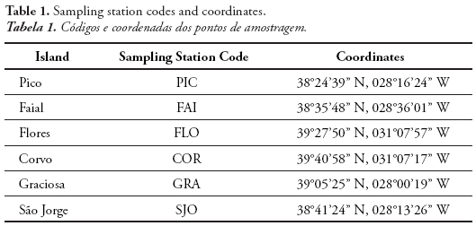
The present work covers the coastal waters of six islands of the Azores, namely Flores and Corvo in the Western group, and Faial, Pico, São Jorge and Graciosa in the Central Group (Figure 1; Table 1). Sampling stations were selected on the basis of their proximity to the most significant population centers of the mentioned islands, therefore the mostly likely to be environmental disturbed. Collection campaigns were conducted during the summer, as this is the most environmental stable time of the year and the most favorable period for fieldwork on the Azorean coast.
Following the concept of reduced species list (Wells et al., 2007), in each a list with the most significant species of a particular area acts as a surrogate to the full species list, a list of the most common algal species in the Azores, either in terms of occurrence throughout the year as throughout the archipelago, was produced. In the mentioned list, some species were grouped in higher taxonomic levels (e.g., genera) or according to morphological similarity (e.g., filamentous Phaeophyceae) as proposed by Neto et al. (2012), resulting in 37 selected taxa. This second reduction helped to avoid misidentifications during the surveys and reduced the time spent preserving samples in the field and specimen identification in the laboratory. The selection was done in a way that the final reduced list was in accordance with the natural proportion of green (Chlorophyta), brown (Phaeophyceae) and red algae (Rhodophyta) found in the Azorean marine flora, i.e., 51:62:261 (Parente 2010). This reduced list represented the basis for the selected indexes, to register the presence of the selected taxa and the cover of opportunistic species. The ecological status group (ESG) of each taxon was stipulated following the directions of Orfanidis et al. (2001). The macroalgae were classified as opportunists according to Wells et al. (2007) and Wallenstein (2011), and as invasive according to Parente (2010). This list, although reduced, was considered appropriate for the objectives of this study since Wallenstein (2011) did not observe significant differences between the use of complete and reduced species lists for the coastal classification of different islands of the Azores.
The shore description was also considered in the characterization of the studied communities since the physical nature of the substratum (e.g., angle and size of the rocks) and the environmental conditions (e.g., turbidity and sand scour) affect species richness and the occurrence of perennial or opportunistic taxa (Wells et al., 2007) which in turn could interfere in the index result by inducing a wrong interpretation of such changes as a result of reduced water quality or anthropogenic influence (Ballesteros et al., 2007). For that reason, these parameters were used to calibrate the indexes to the local natural conditions.
In the intertidal zone, transect readings were performed in the supralittoral, mediolittoral and infralittoral using a 25x25 cm quadrat, with 3 replicates per subdivision. In the subtidal zone, the readings were performed by scuba diving at selected depths (5, 15 and 25m), using a 50x50 cm quadrat (3 replicates per depth), following a transect of a maximum of 25 m long (depending of the sea bottom angle) and 1,5 m wide. The size of transects and quadrats, as well as the number of replicates, were chosen based on previous studies in such a way that the minimum sampling area was assured (Wallenstein et al., 2009). The inclusion of subtidal readings, usually not considered in the ecological quality indexes, not only enabled the inclusion of a larger number of habitats, but also made possible to sample the sites to which there was no access from land or when the waves/tides were too high.
Besides the in loco identification of the presence/absence of macroalgae in the reduced species list, the coverage percentage of the invasive species was also registered in all readings. In the intertidal zone, the abundance of each macroalga was also registered using the DAFOR scale (Kent & Coker, 1992). Conspicuous algae, not included in the mentioned reduced list, were also registered.
Four ecological indexes were used in this study: the Ecological Evaluation Index (EEI; Orfanidis et al., 2001), the Reduced Species List Rocky Shore Tool (RSL; Wells, 2008), Quality of Rocky Bottoms Index (CFR, from Spanish Calidad de Fondos Rocosos; Juanes et al., 2008) and the Marine Macroalgae Assessment Tool (MarMAT; Neto et al., 2012). The British (RSL) and the Portuguese (MarMAT) indexes were originally described for use in the intertidal zone and were also adapted in the present study to include subtidal species. On the other hand, the Spanish (CFR) and the Greek (EEI) indexes were applied only in the intertidal zone, because it was only possible to register the total algal coverage in this zone.
The “Ecological Quality Ratio” (EQR) was calculated to each index, resulting in a 0 to 1 scale, as defined by the WFD (2000/06/CE). EQR values close to 1 indicate pristine conditions while values close to 0 indicate high levels of disturbance, being translated to five classes of “Ecological Quality Status” (EQS): High, Good, Moderate, Poor and Bad.
3. RESULTS
A total of 43 taxa of macroalgae was observed, with Faial, the richest island in number of species, presenting 27 taxa. The number of red algae (Rhodophyta) was larger than the number of brown (Phaeophyceae) and green algae (Chlorophyta) in all water bodies studied, with a total of 26, 10 and 7 observed taxa, respectively (Figure 2). The coastal waters of Faial comprised the largest richness in Rhodophyta (14 taxa). The number of Phaeophyceae was largest in Graciosa, Pico and Flores (7 taxa). The largest number of Chlorophyta observed was 3 taxa, either in the islands of Pico and Faial. Pico presented the largest number of opportunist species (4 taxa), while the smallest number was observed in São Jorge and Graciosa, with 1 species in each.
In general, the abundance of algal species was very variable among the water bodies, and composed of various rare and occasional occurring species. Nevertheless, the intertidal zone of São Jorge was dominated by articulated calcareous red algae that were also abundant in the intertidal zone of Flores and Faial. Among the frequently occurring algae, the following taxa stood out: crustose brown algae and calcareous red algae in Corvo; Codium spp. (Chlorophyta) and articulated calcareous red algae in Faial; crustose calcareous red algae and Laurencia spp. (Rhodophyta) in Pico; Codium spp. (Chlorophyta), Hypnea spp. (Rhodophyta) and crustose calcareous red algae in Graciosa.
The macroalgal communities were analyzed by multivariate ordination (nMDS) based on the presence of each taxon in the intertidal zone and in each sampled depth of the subtidal zone, for every island included in the present work. From the analysis of the species composition (qualitative data), five groups with similarity above 50% can be distinguished (Figure 3; see Table 1 for sampling sites codes). The group SJO_int/GRA_int is related with the algal community GRA_25m, which, together, forms the most dissimilar group. The group FAI_int/PIC_int/COR_int/PIC_int/FLO_int is composed of algal communities which, though somehow similar, present greater variability in their composition. The group COR_20m/COR_5m comprises all the subtidal communities observed in Corvo. At last, the largest group, SJO_25m/PIC_25m/GRA_15m/PIC_15m/FLO_5m/SJO_5m/GRA_5m/SJO_15m/FAI_25m/ FLO_25m/ FAI_5m/FLO_15m/FAI_15m, suggests that there are very similar algal communities in SJO_5m and SJO_15m, as well as in FLO_15m and FLO_25m, and also in GRA_15m and PIC_15m, although the last pair is not as similar as the previous ones (Figure 3).
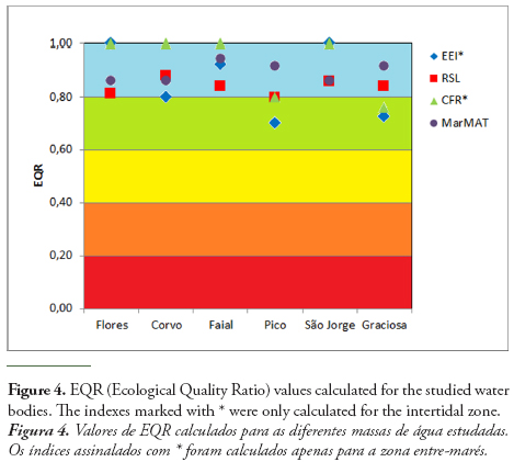
The application of the Ecological Evaluation Index (EEI) resulted in the maximum score of 10.00, meaning an Ecological Quality Ratio (EQR) of 1.0 for Flores and São Jorge. Therefore, these islands obtained “HIGH” Ecological Quality Status (EQS). On the other hand, Faial also achieved a very high score (0.92), with its water quality also classified as “HIGH”. The coastal waters of Graciosa, Pico and Corvo reached a “GOOD” status classification.
The application of the Quality of Rocky Bottoms Index (CFR) indicates that the water bodies of São Jorge, Faial, Flores and Corvo represent maximum EQR values, meaning “HIGH” EQS. With high scores, close to upper limit of the “GOOD” status category, we can find Pico and Graciosa, with EQRs of 0.8 and 0.76, respectively.
Overall, the EQR values resulting from the application of the Reduced Species List Rocky Shore Tool (RSL) was very similar among the different islands, ranging from 0.80 in Pico to 0.88 in Corvo. Hence, all water bodies presented “HIGH” EQS, except for Pico, which is in the upper limit of the “GOOD” status category.
The application of the Marine Macroalgae Assessment Tool (MarMAT) resulted in the maximum ecological classification for all studied islands, i.e., “HIGH” EQS. The EQR values showed very low variation among the different water bodies, with Faial the island with the highest value (0.94).
All results obtained by the application of the mentioned indexes can be observed in Table 2, along with the relevant data used in their calculation. In a more detailed analysis, it is possible to conclude that: (1) a larger number of opportunist taxa (4 species) was observed in Pico; (2) the largest coverage of opportunist algae (21.4%) was detected in Corvo; (3) the most predominant group of algae in the Rhodophyta with percentage of occurrence between 53% and 64%; (4) the water bodies of Faial and São Jorge presented very high Rhodophyta/Phaeophyceae ratio (R/P), with 2.8 and 2.4, respectively; (5) Flores, Faial and São Jorge achieved the “HIGH” status qualification in all indexes used, while Corvo reached “HIGH” status in 3 indexes, Graciosa in 2 and Pico in only one.
All calculated ERQ values are represented in Figure 4. It is noticeable that the indexes based only on intertidal data presented more variable values among islands.
4. DISCUSSION
In the present study, the total number of taxa observed did not vary considerably among the sampling sites, although the floristic composition was different between islands, especially in the intertidal zone. These contrasting results are probably due to the fact that the sampling sites selected for this study represent different morphological characteristics. Thus, as the intertidal and subtidal zones were considered as a sum of the different habitats, the total number of taxa was very similar between the islands. On the other hand, the species assemblages at the different subtidal depths of all the studied water bodies are more similar among them than the various intertidal assemblages. This result reflects the environmental instability in the intertidal zone and the greater diversity of sub-habitats in the subtidal of all the sampled sites. Wallenstein (2011), focusing only in the intertidal zone of the Azores, has already concluded that the number of species in that zone is as variable within islands as between different islands. This fact, resulting from a high variable environment, combined with the small number of sites sampled, makes it very difficult to interpret the geographic patterns of the species composition observed in the intertidal zone. The number of species per island registered by Wallenstein (2011) tended to increase with the number of sites sampled in each island, revealing a cumulative effect in the species richness as a result of increase in the sampling effort.
Species richness tended to decrease with depth down to 15 m, slightly increasing at 25 m depth. Corvo Island represented an exception, since the number of species observed was directly proportional to the increase of depth. This is probably due to its geographical orientation, which resulted in a greater exposure for the algal communities to cliff landslides and wave action, more protected in greater depths.
The dominant macroalgae of the intertidal zone were the crustose and articulated calcareous red algae, whose abundance reflects the presence of high-energy waves of those coasts. Other frequently occurring species were an encrusting species of Codium and various species of agarophyte turf-forming red algae, both habits reflecting adaptation to wave exposure (Wallenstein et al., 2009). As expected, species richness was greater where highest water temperatures were observed, but also in the islands of the Triangle, i.e., Faial, Pico and São Jorge, probably as a result of the lower exposure to waves, since the sampling sites corresponded to more protected areas (Rusu & Soares, 2012) favoring the fixation and survival of a larger number of species.
In the Northern hemisphere, the proportion of Rhodophytes decreases with latitude, with 60 to 70% of red algae around 40° N and 30 to 40% in the Arctic (Santelices et al., 2009). The present data decreased with latitude but revealed slightly lower values than what would be expected for the studied latitude. This might be due to the island effect on the number of species (Kier et al., 2009) or to the fact that the species-rich group of filamentous red algae was not identified to species level. A slightly higher number of species in the islands of the Triangle (Faial, Pico and São Jorge) might be related to lower wave action and/or other biological factors not considered in the present work, such herbivory, mostly by fishes (Taylor & Schiel, 2010). The proportion of opportunistic algae observed here varied between 5 and 8%, which is in agreement with Wallenstein (2011), who determined that an average proportion of 0.10 (±0.06), with a maximum of 0.38, with 70% of all his sampling sites presenting 5 to 15% of opportunistic algae. In the mentioned study, the variability found between islands was too high to enable any conclusion concerning the difference between islands. However, the data of the present work indicates a tendency for lower proportion of opportunists in waters of better ecological conditions, even when this metric (proportion of opportunists) (proportion is not included in the index used. From the three invasive species of macroalgae reported by Cardigos et al. (2006), only one was observed in the studied collection sites, the red alga Asparagopsis armata.
Wallestein (2011) registered an average ESG ratio of 1.4 (± 0.06) in the Azores Archipelago, with 85% of the sampled areas with a value above 1.0, indicating a tendency of the communities to be dominated by late-succession species. The present data are in agreement with Wallenstein (2011), since 4 of the 6 studied water bodies obtained an ESG rate of 1.4.
The R/P (Rhodophyta/Phaeophyceae) ratio varies between 1.0 and 2.0 in temperate waters, and may reach 4.3 in tropical waters (Witman & Roy, 2009). In the present study, the calculated R/P ratio was between 1.4 and 2.8 for the different water bodies, reinforcing the suggestion of Titley & Neto (2005) that the algal communities of the Azores present characteristics of a temperate water flora, though also having tropical influences. Even though the R/P ratio is not considered to be a very precise biotic index (Marques et al., 2009), this ratio has been used as an indicative in water quality classification, showing some separation between different water bodies conditions. As observed by Azzopardi & Schembri (2010) for the Mediterranean, the present results show that the water bodies grouping based on R/P ratio values reflects the same classification from the application of other biotic indexes. Therefore, the coastal waters of the islands classified as having a GOOD status by other indexes (Corvo, Pico and Graciosa) presented very similar R/P ratio values.
The islands of Faial, São Jorge and Flores achieved a “HIGH” EQS classification in the four indexes used, i.e., EEI, RSL, CFR and MarMAT, while Corvo was classified as having a “HIGH” status in three, Graciosa in two and Pico in only one of the indexes. MarMAT application resulted in “HIGH” EQS for all water bodies, with Faial the one with the highest EQR value (0.94). The calculated EQR values vary according to the index used, but they all indicate that the Azorean coastal waters are in good or excellent condition. This result is in accordance with the expected, considering that the Archipelago of the Azores is isolated in the middle of the North Atlantic, with a population of only about 250 thousand inhabitants, and does not present any significant industrial activity, representing a close to reference condition state, i.e., with reduced human interference and low anthropogenic pressure.
In general, the values resulting from the application of the different indexes are very similar among the islands, with the tendency to vary even less when subtidal data are included. This greater homogeneity may be related to the occurrence of the greater diversity of habitats observed in the subtidal zone, which might result in a more complete registration of the present species, contributing to a greater precision in the indexes’ use. On the other hand, the intertidal surveys are dependent on the conditions of the sea, the tidal amplitude and the wave heights, reinforcing the need to include subtidal data. The greater instability of the intertidal habitats may also influence the results, and, once again, a larger replication if sampling sites per island would guarantee stronger data. In reality, the natural variation is the basis against which the effects of any anthropogenic change have to be contrasted to be detected and measured (Coleman, 2002) and that might be the less understood characteristic of marine ecosystems (Smayda 1984). This variation includes spatial and temporal components which are difficult to consider in the experimental planification and might determine the sampling scales (Coleman, 2002). Even when the sampling comprises a large range of natural variation, which is related to the sample size and replication (Skalski & McKenzie, 1982), the ability to statistically differentiate the impacted condition from the reference condition still depends on the size of the impact to be detected.
Additionally, in consequence of its geographic location near an amphidromic point in the North Atlantic, which determines small tide amplitudes, and because of its steep coastline, the area available for intertidal species fixation is very limited in the Azores. Therefore, besides the island factor that limits the available number of native species to be included in the indexes, the reduced intertidal area for algal fixation has also to be considered, reinforcing the need to include the subtidal zone in the coastal water classification for the WFD.
5. CONCLUSIONS
This preliminary work indicates that all coastal water bodies included here reaches the environmental goals established by the WFD and that most of them represent “HIGH” quality conditions.
The present data reflect the evolution of the ecological indexes, considering that, as they were created, the existing metrics were adapted and innovative ones were incorporated into new indexes, resulting in the fact that the most recent indexes seem to be more complete in terms of incorporated information. MarMAT revealed to be the most efficient index in the present study, since it seemed to be the most coherent by not presenting extreme EQR values. Moreover, this index included metrics that cover all the required features to be considered under the WFD, metrics for which data can be easily acquired by non-specialist personnel.
The inclusion of subtidal readings in the MarMAT index was justified by the small width of the intertidal zone in the Azores and by the great instability to which this zone is subjected to high wave action. These two factors limit the spatial availability and the environmental conditions for species colonization and succession that in turn might affect the results when the sampling is restricted to this zone, since there is greater variability, fewer species and greater abundance of opportunists. Therefore, by including subtidal data, these problems are compensated and the final result is more accurate for monitoring purposes.
Future work should increase spatial replication by increasing the number of sampling sites in each of the water bodies to guarantee representativeness and overcome interference of natural spatial variation of the biological elements used in the ecological status evaluation. Considering that the coastline different morphologies, the selection of future sampling sites should focus on coasts with different hydromorphological characteristics in every island. The validation of the adaptation of the different indexes used will depend on the comparison between some of these pristine sites and other strongly affected by human activities (e.g., close to outfalls).
It should also be taken into consideration that, for its subtropical location, the Azorean macroalgae might suffer a significant effect of herbivory, especially by fishes (Taylor & Schiel, 2010). Therefore fishes could become a parameter to be included in coastal waters monitoring, since it probably is an important element contributing to the structure of the macroalgal community itself (Costa, 2003).
Finally, the results presented here indicate a good chance for the use of the MarMAT index adapted to the Azores (MarMAT-Az) for ecological evaluation and monitoring of the archipelago coastal waters under the application of the WFD or whenever the quality of the coastal environment is to be evaluated, such as in impact assessment studies. Additionally, the methodology followed here for the adaptation of the index for the studied region, is promising for the adaptation of this index for other geographical settings.
ACKNOWLEDGMENTS
The authors thank the support of Paula Aguiar, Cátia Pereira, Cláudia Hipólito, João Brum, Paulo Torres, Vitor Gonçalves, Agroleico Lda., and the skipper of “Alabote” and “Odisséia” vessels, for help with field work and/or data treatment. This work would not have been possible without funding from the Regional Direction of Land Management and Water Resources (DROTRH). The authors are also thankful to Leonel Pereira, Roberto Campos Villaca and the anonymous reviewer for their contributions in improving the manuscript.
REFERENCES
Azzopardi, M.; Schembri, P.J. (2010) - Assessment of the ecological status of Maltese coastal waters using the Rhodophyta/Phaeophyta Mean Ratio Index (R/P Rt. I.). Rapport du Congrès de la Commission Internationale pour l’Exploration Scientifique de la Mer Méditerranée, 39:718, Monaco. Available on-line at http://www.ciesm.org/online/archives/abstracts/index.htm
Ballesteros, E.; Torras, X.; Pinedo, S.; García, M.; Mangialajo, L.; Torres, M. (2007) - A new methodology based on littoral community cartography dominated by macroalgae for the implementation of the European Water Framework Directive. Marine Pollution Bulletin, 55(1-6):172-180. DOI: 10.1016/j.marpolbul.2006.08.038 [ Links ]
Borges, P. (2003) - Ambientes litorais nos grupos Central e Oriental do Arquipélago dos Açores, conteúdos e dinâmica de microescala. 413p., PhD thesis, Universidade dos Açores, Portugal. Unpublished. [ Links ]
Borges, P.; Gabriel, R. (2009) - Predicting extinctions on oceanic islands: arthropods and bryophytes / Estimar extinções em ilhas oceânicas: artrópodes e briófitos. 80p., Grupo de Biodiversidade dos Açores, Angra do Heroísmo, Portugal. ISBN: 978-9728612511. [ Links ]
Cardigos, F.; Tempera, F.; Ávila, S.; Gonçalves, J.; Colaço, A.; Santos, R.S. (2006) - Non-indigenous marine species of the Azores. Helgoland Marine Research, 60(2):160-169. DOI: 10.1007/s10152-006-0034-7 [ Links ]
Coleman, M. (2002) - Small-scale spatial variability in intertidal and subtidal turfing alga assemblages and the temporal generality of these patterns. Journal of Experimental Marine Biology and Ecology, 267(1):53-74. DOI: 10.1016/S0022-0981(01)00358-6 [ Links ]
Costa, A.C. (2003) - Diversidade de invertebrados das comunidades algais no subtidal de São Miguel e perturbação ambiental. 196 p., PhD thesis, Universidade dos Açores, Portugal. Unpublished. [ Links ]
EC (2000) - Directive 2000/60/EC of the European Parliament and of the Council of 23 October 2000 establishing a Framework for Community Action in the Field of Water Policy. Official Journal of the European Communities, 327(22/12/2000):1-73, Brussels, Belgium. Available on-line at http://eur-lex.europa.eu/legal-content/EN/TXT/?uri=celex:32000L0060 [ Links ]
Fernandes, J. (1985) - Terceira (Açores). Estudo geográfico. 434 p., PhD thesis, Universidade dos Açores, Portugal. Unpublished. [ Links ]
Forjaz, V. (1963) - Resumo geológico das Ilhas dos Açores. Atlântida (ISSN: 1645-6815), 8(4–5):243–245. Instituto Açoriano de Cultura, Angra do Heroísmo, Terceira, Açores, Portugal.
Juanes, J.A.; Guinda, X.; Puente, A.; Revilla, J.A. (2008) - Macroalgae, a suitable indicator of the ecological status of coastal rocky communities in the NE Atlantic. Ecological Indicators, 8(4):351-359. DOI: 10.1016/j.ecolind.2007.04.005 [ Links ]
Kent M.; Coker, P. (1992) - Vegetation description and data analysis. A practical approach. 363p., John Wiley and Sons, Chichester, England, U.K.. ISBN: 978-0471490937. [ Links ]
Kier, G.; Kreft, H.; Lee, T.M.; Jetz, W.; Ibisch, P.L.; Nowicki, C.; Mutke, J.; Barthlott, W. (2009) - A global assessment of endemism and speciesrichness across island and mainland regions. Proceedings of the National Academy of Sciences of the United States of America, 106(23):9322-9327. DOI: 10.1073/pnas.0810306106 [ Links ]
Lafon, V.; Martins, A.; Figueiredo, M.; Melo Rodrigues, M.A.; Bashmachinikov, I.; Mendonça, A.; Macedo L.; Goulart, N. (2004) - Sea surface temperature distribution in the Azores region. Part I: AVHRR imagery and in situ data processing. Arquipélago - Life and Marine Sciences, 21A:1-18, Açores, Portugal. Available on-line at http://www.horta.uac.pt/intradop/images/stories/arquipelago/21a/1_Lafon_et_al_21A.pdf [ Links ]
Marques, J.C.; Salas, F.; Patricio, J.; Teixeira, H.; Neto, J.M. (2009) - Ecological indicators for coastal and estuarine environmental assessment; a users’ guide. 208p., WIT Press, University of Coimbra, Portugal. ISBN: 978-1845642099.
Neto, A. (1997) - Studies on algal communities of São Miguel, Azores. 309 p., PhD thesis, Universidade dos Açores, Portugal. Unpublished. [ Links ]
Neto, J. M.; Gaspar, R.; Pereira, L.; Marques, J.C. (2012) - Marine Macroalgae Assessment Tool (MarMAT) for intertidal rocky shores. Quality assessment under the scope of the European Water Framework Directive. Ecological Indicators, 19:39-47. DOI: 10.1016/j.ecolind.2011.09.006 [ Links ]
Orfanidis, S.; Panayotidis, P.; Stamatis, N. (2001) - Ecological evaluation of transitional and coastal waters: A marine benthic macrophytes-based model. Mediterranean Marine Science (ISSN: 1108-393X), 2(2):45-65, Hellinikon, Greece. Available on-line at http://www.medit-mar-sc.net/files/200812/14-1940245.pdf [ Links ]
Parente, M.I. (2010) - List of marine macroalgae (Rhodophyta, Chlorophyta and Phaeophyceae) In: Borges, P.A.V., Costa, A., Cunha, R., Gabriel, R., Gonçalves, V., Martins, A.F., Melo, I., Parente, M., Raposeiro, P., Rodrigues, P., Santos, R.S., Silva, L., Vieira, P.; Vieira, V. (eds.) A list of the terrestrial and marine biota from the Azores, 432 p., Princípia, Cascais, Portugal. ISBN: 978-989-8131-75-1. [ Links ]
Rusu, L.; Soares, C.G. (2012) - Wave energy assessments in the Azores islands. Renewable Energy, 45:183-196. DOI: 10.1016/j.renene.2012.02.027 [ Links ]
Santelices, B.; Bolton, J.J.; Meneses, I. (2009) - Marine Algal Communities In: Witman, J.D. & Kaustuv, R. (eds.), Marine Macroecology, 440 p., University of Chicago Press. Chicago, IL, U.S.A. ISBN: 978-0226904122. [ Links ]
Skalski, J.; McKenzie, D. (1982) - A design for aquatic monitoring programs. Journal of Environmental Management (ISSN: 0301-4797), 14:237-251. [ Links ]
Smayda, T. (1984) - Variations and long-term changes in Narragansett Bay, a phytoplankton-based coastal marine ecosystem: relevance to field monitoring for pollution assessment In: White, H. (ed.) Concepts in marine pollution measurements, 757p., College Park: A Maryland Sea Grant Publication, University of Maryland, College Park, MD, U.S.A. ISBN: 978-0943676180. [ Links ]
Taylor, D.I; Schiel, D.R. (2010) - Algal populations controlled by fish herbivory across a wave exposure gradient on southern temperate shores. Ecology, 91:201-211. DOI: 10.1890/08-1512.1 [ Links ]
Titley, I.; Neto, A.I. (2005) - The Marine Algal (Seaweed) Flora of the Azores: further additions and amendments. Botanica Marina, 48:248-255. DOI: 10.1515/BOT.2005.030 [ Links ]
Wallenstein, F.M. (2011) - Rocky Shore Macroalgae Communities of the Azores (Portugal) and the British Isles: a Comparison for the Development of Ecological Quality Assessment Tools. 434p., PhD thesis, School of Life Sciences, Heriot-Watt University, Edinburgh, Scotland, U.K. Unpublished. [ Links ]
Wallenstein, F.M.; Neto, A.I.; Álvaro, N.V.; Tittley, I.; Azevedo, J.M.N. (2008) - Guia para identificação de biótopos costeiros em ilhas oceânicas, 92 p. Secretaria Regional do Ambiente e do Mar, Ponta Delgada, Portugal. ISBN: 978-9729988493. [ Links ]
Wallenstein, F.M.; Terra, M.R.; Pombo, J; Neto, A.I. (2009) - Macroalgal turfs in the Azores. Marine Ecology, 30(s1):113-117. DOI: 10.1111/j.1439-0485.2009.00311.x [ Links ]
Wells, E. (2008) - Intertidal Coastal Waters Macroalgae – Rocky Shore Tool. Tools paper prepared for the UK and Republic of Ireland. Water Framework Directive Marine Plants Task Team (MPTT/MAT01), 36p., Edinburgh, Scotland, U.K. Unpublished.
Wells, E.; Wilkinson, M.; Wood, P.; Scanlan, C. (2007) - The use of macroalgal species richness and composition on intertidal rocky seashores in the assessment of ecological quality under the European Water Framework Directive. Marine Pollution Bulletin, 55(1-6):151-161. DOI: 10.1016/j.marpolbul.2006.08.031 [ Links ]
Witman, J.D.; Roy, K. (2009) - Marine macroecology. 440p., University Of Chicago Press, Chicago, IL, U.S.A. ISBN: 9780226904122. [ Links ]
*Submission: 28 December 2013; Evaluation: 1 February 2014; Reception of revised manuscript: 3 May 2014; Accepted: 28 May 2014; Available on-line: 6 June 2014

