


Serviços Personalizados
Journal
Artigo
 Inglês (pdf)
 Artigo em XML
 Referências do artigo
 Enviar este artigo por email
Indicadores
-
 Citado por SciELO
 -
 Acessos
Links relacionados
-
 Similares em
SciELO
Similares em
SciELO
Compartilhar

 Permalink
Revista de Gestão Costeira Integrada
versão On-line ISSN 1646-8872
RGCI vol.12 no.4 Lisboa dez. 2012
Áreas de Proteção Marinhas para Pesca na Andaluzia *
Marine Protection Areas for Fishing in Andalousia
Carlos Norman Barea @, 1, Daniel Guerrero Albarral 2, Carmen Ortega González 2
@ - Corresponding author
1 - Biology Department. Ecology Area . Cádiz University. e-mail: carlos.norman@uca.es
2 - Fishery Department. Agriculture and Fishery Administration in Granada. Junta de Andalucía. e-mail: daniel.guerrero@juntadeandalucia.es
ABSTRACT
A comparative study of Marine Protected Areas for Fisheries (MPAF) placed in the south of Spain that have already been declared (Guadalquivir basin and Huelva coast line) and that are in process of declaration (Roche cape and Calahonda-Castell de Ferro) has been the target of this work. This work reviews the administrative documentation available through the comparative contrast of 6 criteria and 18 parameters to achieve a characteristic profile of each MPAF and a characterization of how a MPAF without conflicts have to be managed. Of all the obtained results we point out different management models applied in the MPAF, lacks in the planning of specific and quantifiable objectives, the various options of commercial fishing and the gradient of complexity and biological diversity that is detected in the different natural resources that have motivated the statement or the proposal statement of each of the MPAF. Finally after the discussion of the results, it is concluded that the fisheries administration should promote protection initiatives, which keep in mind the shared management or co-management and integrated coastal zone management plan.
Keywords: fisheries, Marine Protected Area (MPA), management, Andalousia, Spain.
RESUMO
Este trabalho apresenta um estudo comparativo das zonas marinhas de pesca protegida, realizado no sul de Espanha, que já foram declaradas na Andaluzia (Foz do Guadalquivir e Costa de Huelva), e das duas pendentes de declaraçao (Cabo Roche e Calahonda - Castell de Ferro). É revista a documentação administrativa disponível através da comparação de 6 critérios e 18 parâmetros tendo sido obtido um perfil característico de cada uma das reservas e uma caracterização de como deve ser gerida uma reserva procurando minimizar os conflitos ambientais. De entre os resultados destacamos os diferentes modelos de gestão aplicados em Áreas de Proteção Marinhas para Pesca (APMP), lacunas no planejamento de objectivos específicos e quantificáveis, as diversas formas de pesca comercial e o gradiente de complexidade e diversidade biológica que é detectada em diferentes recursos naturais que motivaram a declaração de APMP ou a proposta de declaração conforme apropriado. Finalmente após a discussão dos resultados conclui-se que a gestão das pescas deverá promover iniciativas de proteção que levem em conta a gestão compartilhada e plano de gestão integrada da zona costeira.
Palavras-chave: pesca, áreas marinhas protegidas, gestão, Andaluzia, Espanha
1. Introduction
In the past 20 years, the international community has shown a growing interest not only in land species and habitat protection but also in marine ecosystems (Montoya, 1991; Suárez de Vivero and Rodríguez Mateos, 2005). In Europe, marine conservation has become a priority policy with the signing of several and important international agreements and the adoption of several laws (Directive 92/43/CEE, Directive 2008/56/CE and Regulation Nº 1967/2006)
In Spain, law 42/2007 on Biodiversity and Natural Heritage establishes Marine Protected Areas as one of the categories of protected natural areas, allowing their integration in an interconnected network. In addition, law 41/2010 on environmental marine protection, provides the ideal legal framework for the adoption of necessary measures for the maintenance of the marine environment.
On the other hand, the fisheries Administration of Spain, with the Law 3/2001, has allowed the declaration of Marine Protected Areas for Fisheries (MPAF) to promote the protection and regeneration of marine resources.
The declaration of natural protected areas in coastal zone, following the adoption of Law 2/1989 on protected areas catalogue, has been the legal instrument designed for marine protection in Andalusia. In addition, Law 1/2002 on Planning, Development and Control of fisheries, allows the declaration of Marine Protected Areas for Fisheries. MPAF are breeding, spawning, rearing or fattening areas with special conditions for the development of fisheries resources. The Agriculture and Fisheries regional administration of Andalusia has declared two MPAFs, one in the Guadalquivir basin -FAGB-, by Order 16 June 2004, and another in the coast of Huelva -FACH- by Order 1 April 2011. Presently a MPAF in Roche Cape (Cádiz) -FARC- and a MPAF in Castell de Ferro (Granada) -FACF- are in process of declaration. These four MPAFs have been analysed in this study, from the documentary point of view, in order to detect if the planning differences and existing analogies between them that allow to define guidelines on as it should be a MPAF in Andalusia, for the purpose to avoid the problems of management that the current working MPAF have. When selecting marine protected areas, Ray (1999) admits there are serious challenges in a scientific approach, even more under a management point of view, but considers there is no better way to identify and help select areas, to address uncertainty, to increase accountability and to involve the public via generation of credible information. Although marine protected areas for fisheries does not look like different from the marine protected areas with multiple objectives. The daily management and profile of the managers induces suspicion on the possibility that there may be certain differences.
Fisheries and marine conservation scientists generally operate within two different contexts as the application of their work is often linked to practitioners that need to meet different management objectives: marine ecosystem conservation vs achieving sustainable social and economic benefits from fisheries. Fisheries managers typically aim to keep stocks around a target reference point, typically the biomass that produces some proxy of maximum sustainable yield (MSY), and avoid going beyond biomass or fishing mortality limit reference points (Caddy and Mahon 1995). Marine conservation scientists and practitioners have often supported the notion of permanent spatial closures, i.e., marine reserves to protect population and community dynamics and biodiversity. The risk aversion characteristic of this community results in a preference for management tools and science that fully supports a precautionary approach and facilitates the preservation of at least some part of an areas habitat and associated communities. This approach was limited to small spatial and temporal scales owing primarily to the logistical constraints of experimentation and replication. Information gathered at small scales can result in relatively strong inference due to the use of controls, but is difficult to scale up to the much larger scales at which many fisheries operate. Fisheries science depends heavily on long time series of data and parameterization of population models designed to describe phenomena over very large spatial and temporal scales while experimental manipulations are rare. Furthermore, fisheries stock assessments are not usually spatially explicit, and hence have a hard time incorporating closed areas or MPA, besides the often lack of ecological heterogeneity consideration (García Charton and Pérez Ruzafa, 1999)
Conservation practitioners tend to be more concerned with the risk of exceeding reference points and with risks to habitat and biodiversity than with maximizing yield. While the contexts are separate (fisheries management vs marine conservation), objectives can converge where there is agreement about the reference points, the appropriate buffers, the status of stocks relative to the reference points, and appropriate measures to protect habitats. There is also increasing convergence around the goal of maintaining populations of large, old spawners due to their disproportionately high contribution to the larval pool and their important ecological roles (Caddy & Seijo 2002). Ultimately, understanding the ecological, social, and economic performance of both fisheries and conservation initiatives requires an improved understanding of linked socialecological systems (McEvoy, 1986; Francis et al., 2007).
The present article, with a general point of view as Francis et al., (2007) proposed, aims to approach the problem of planning and managing of MPAF by the andalousian administration of fisheries using the comparative analysis between four MPAF contrasted against 6 criteria and 18 parameters which are latterly described.
2. Methodology
An analysis of several criteria with their associated parameters (Table 1) to characterize and compare the four selected MPAFs have been proposed. The choice of these Marine Protected Areas for Fisheries is justified because all are Marine Protected Zones, nowadays in Andalousia, are not included in any planning of Integrated Coastal Zone Management (ICZM), whose reasons are based probably on the scarcity of the relations and coordination between differents levels and scopes from the concerned Goverments (Barragan, 2005).
The physical and ecological features, although do not provide great information from the point of view of the management, serve to demonstrate that the ecological differences incorporated in the delimitation of a MPAF are used with common management criteria for different marine protected areas. Is particularly interesting to note the control of interference referred the consideration whether or not of the reserve effect versus the habitat effect (García Charton & Pérez Ruzafa, 1999)
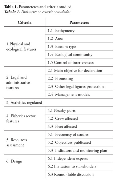
The legal and administrative features listed in table 1, mainly refer to the planning mechanisms used in the process of Declaration of MPAF and to the management tools intended to be used for its development. A parameter that aims to reveal who is the original author of the idea of promoting the MPAF has been developed specifically for this criterion. Similarly the regulated activities section provides information on what types of fishing can perform in each area of their respective MPAF.
The characteristics of the fisheries sector are to define and describe the possible influences of fishing activity in studied MPAF and on their fishery resources. The assessment of resources section seeks to verify whether the valuation of resources is really done in the MPAF already declared and if it poses as a goal or requirement in the MPAF do not declare yet; with that frequency occur evaluations and if they are integrated or not in a particular fishery resources monitoring plan.
The parameters of last criterion included in table 1 is an attempt to estimate whether there has been a proper process of participation in the design phase of the MPAF involved in this work.
3. Results
The results obtained are described in the next paragraph following the same mentionated order in table 1.
3.1. Physical and ecological Features
3.1.1. Bathymetry
While in FACH, depth of 10m is located only to 2,5miles to the beaches; in FAGB we must go deeper than 6,5miles to reach this 10m. The 50m depth is located more than 9,5miles offshore in FARC, and it has a varied topography with small hills and depressions, the forms are always smooth. In contrast to this, the FACF slope is higher than others, reaching 80m in only 2miles (Figure 1).
3.1.2. Area
FARC and FAGB are the two zones with the largest areas (680 and 404km²) .On the other hand we find the FACF, with 29km², and finally the FACH is the one with the smallest area (16,5Km²).
3.1.3. Bottom type
FACH has a basically sandy bottom while FACF and FAGB contain, in addition to sand, 50% of rock, and some mud in the case of FACF and sludge small inroads in the case of FAGB. On the other hand, the FARC has a rocky core surrounded by sandy bottoms and two spots of gravel.
3.1.4. Ecological community
Both FAGB and FACH are characterized by muddy detritic communities of animals in the bottom, with an abundance of bivalves in the Huelva coast and a higher percentage of nursery and recruitment into the estuary of Guadalquivir river. The FACF and FARC share a rocky and biocenosis of benthic detritivores, characteristic of such seabeds.
3.2. Legal and administrative features
3.2.1. Main objective for declaration
The FACH aims to protect and manage a traditional fishery area of bivalve molluscs while the FAGB protects an importan high productivity system rich in nutrients. This FAGB is a fish and shellfish breeding and fattening area of great interest. Furthermore, FARC has two different goals: the conservation of environmental heritage and a sustainable management of fisheries. The FACF is characterized by numerous rock shelters and biodiversity of invertebrates and fauna associated with these seabeds although there is no commercial fishing, it has the ideal conditions for the development of angling and diving.
3.2.2. Promoting
The Regional administration is the main promoter of the MPAFs in Andalousia, mainly because regional Governments as Andalusia are obliged to follow the recommendations of the European Union and, in May 2011, the European Commission adopted a new strategy that lays down the framework for EU action over the next ten years in order to meet the 2020 biodiversity headline target set by EU leaders and among them is the goal to preserve vulnerable marine ecosystems in accordance with EU legislation and to promote the involvement of the sector in alternative activities, such as eco-tourism, monitoring and managing marine biodiversity, and combating marine litter. Only the FARC emerged as a result of the initiative of Conil Fishermen´s Association in collaboration with an ecological NGO who proposed the creation of this marine protected area based on their experience and their knowledge of this area.
3.2.3. Other legal figures of protection
Figure 2 shows the overlap of MPAF with other areas under legal protection, for instance: artificial reefs. These artificial structures usually share spaces with areas of high interest for the protection, regeneration and development of fishery resources. Additionally, the Natura 2000 Network program is working in the defense of marine protected areas and therefore there are lots of administrative coincidences and spatial overlaps.
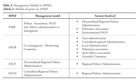
3.2.4. Management models
Management models are the strategy that each MPAF follows when a decision must be taken in the direction toward a goal. These strategies are summarized in table 2. We have considered it important to note that no one of the MPAFs has been integrated in any planning about Integrated Coastal Zone Management (ICZM), which regrettably reduces the social implications (Sanchirico et al., 2002).
3.3. Regulated Activities
The regulated activities can be found in the declaration law of each MPAF. Some marine protected areas have zones for fishing, changing the permited uses with the differents zones. For example on FAGB the activities regulated in four different areas are described (Figure 3; Table 3).
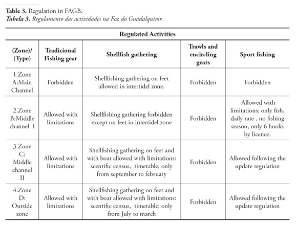
In other areas there are several rules for different activities. For instance, shellfishing gathering on feet and with diving equipment is allowed in all the FACH zone, although in this same area the commercial fishing is forbidden and angling is allowed in accordance with the specific legislation about sport fishing. Scientific activites are allowed in all the MPAFs with special govermental permission. Only the traditional fishing gears -artisanal fisheries- and sport fishing are allowed in FARC, except in the reserved areas. And finally, in FACF only sport fishing and consevation activities are allowed.
3.4. Fisheries sector features
3.4.1. Ports in the influence area and affected crew
Use Planning is required when a MPAF is declared and a decrease in the fishing uses arises and the crew and dependent population of the nearby ports are also affected (Clark, 1998). However not always the case so, in Andalusia since the Declaration of the first MPAF in Guadalquivir basin on the year 2004, the only thing that can be found in official statistics is a general decline in the number of vessels, from 1768 in 2005 to 1523 in 2010, although it may not be concluded, due to lack of data, that the MPAF Declaration contributes to the overall decline of the Andalusian fleet. According to the data of the Andalusian fisheries administration, from 2004 to 2010 there is a descent of the fleets in trawlers (from 428 to 320), encircling gears (from 243 to 182) and shellfish gathering (from 241 to 138), while traditional gears remain approximately the same number (from 699 to 692), although these variations can not relate clearly the changes that may have occurred in the two MPAF already declared (FAGB and FACH).
3.4.2. Affected Fleet
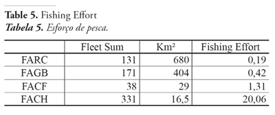
The number of vessels from the different fishing gears have been collected to characterize the potencial intensity of fishing uses in each MPAF as shown in table 4, and the more often fishing uses arise with the traditional gears. A fast assesment of the fishery effort has been made by consideration the following relation: Fishing Effort = Fleet Sum / Km². As shown in table 5 the highest value is obtained in FACH, where the most important fleet is composed by the traditional gears.
3.5. Resources assessment
3.5.1. Frequency of studies
All of MPAF had a previous evaluation of the marine resources except the Roche Cape Area (FARC). This lack of studies prior to the proposal of declaration is due largely to the promotion of the MPAF has not become by the fisheries administration. In the other three MPAF do not foresee reviews, and does not establish the validity or the review period.
3.5.2. Objectives
Both MPAF already declared and the MPAF in proccess of declaration have no quantifiable, measurable and comparable with other MPAF objectives as recommended by many authors (Salm et al., 2000; Fernandes et al., 2005; Pomeroy et al., 2006). In all areas of this study objectives are programmatic and are closer to the institutional propaganda than valid targets to improve the management and conservation of resources covered by the Declaration.
3.5.3. Indicators and monitoring plan
They have articulated neither indicators of follow-up nor specific objectives and quantifiable enable to verify the achievement or otherwise of the objectives proposed in the documents of Declaration. So also, there are not specific task or indicators monitoring to assess the balance between the harms and the benefits of MPAF which has been defined.
3.6. Design
3.6.1. Independent experts
Spanish Institute of Oceanography has acted as external expert for previous studies carried out in three of them (FACH, FAGB and FACF). Design exclusion zones and areas of restricted use recommendations issued reports for the four areas.
3.6.2. Invitation to stakeholders
There have only been involvement of stakeholders in the design process of the two areas that are not yet declared.
3.6.3. Round-Table discussion
Have only been panel discussions at the previous setting of the proposal made to the Area of Roche cape.
4. Discussion
An analysis of the bathymetry and digital elevation model of the seabed shows two different patterns. Western Atlantic MPAFs are strongly influenced by sedimentary processes that give a flat relief and marine bottoms which are mostly sandy with some of sludge. On the other hand, less influenced by sedimentary processes with larges areas of rocky erosion platforms can be found on the mediterranean MPAFs. Roche capes area has a varied topography with small hills and depressions. Their marine bottoms always have smooth slopes with a high proportion of rock. Calahonda-Castell de Ferro is strongly influenced by the mountainous Betic sistems, which sink directly on the sea and also the FACF is influenced by a river network that are based on short and steep slopes. As a result, the slope is stronger than other areas and rock and gravel bottoms can be often found. The geomorphological study shows that different backgrounds and biological communities are present on MPAFs, for providing the protection of the marine biodiversity. We suggest that the type of bottom and communities protected are closely related like it happens in other areas (Ballinger et al., 1994). While sandy bottoms are rich in seafood, the rocky bottoms are the main places where the breeding and the spawning grounds of angling and commercial icthyofauna happens (Kelleher & Kenchington, 1992). A correlation between the protected area, the physical limits of the mouth of Guadalquivir river and the Doñana National Park is seen in FAGB, extending the protection offshore. The small area protected in FACH discreetly covers the mouths of three rivers (Guadiana, Piedras and Tinto River). In Granada, the FACF proposed limits try to cover Calahonda and Castell de Ferro site which belong to the Natura 2000 Network and the artificial reef area, extending the protection to the east covering seabeds of Cambriles place. It could be said that eastern MPAF have some more complex ecological features, which induce to think that also can hold a greater biodiversity (García Charton et al., 2000), which in turn implies a greater degree of complexity in the management of these areas.
All the MPAFs have a common goal, the protection of fisheries resources (Montoya, 1991). However, according to the MPAF, there are different specific objectives, different zonation and a varied degree of overlap between categories of protected areas. So FACF is focused on sport fishing resources while FACH focuses on shellfish resources. FAGB seeks to protect species by keeping their habitats, which are of great interest for its dynamism and its ability to act as an area of recruitment of fish species. Finally FARC pursues its objective through the promotion of sustainable artisanal fishery. All MPAFs have one thing in common: no one have been considered in a management tool as important as Integrated Coastal Zone Management (Barragan, 2003). Without a doubt the most interesting differences with regard to the comparative analysis of the management are reached to observe the gradient of hierarchy that exists in the decision-making. The Regional Fishery Administration in Andalusia apply two basic models of management: centralized and decentralized. In the first of them decisions are taken away from the location where they will be applied. It is a very hierarchical model with a slow response to the problems that arise in everyday life. In the second case decisions are taken in the same place where they are applied. There is a less hierarchical structure and response to problems is faster, however has a drawback in terms of costs, since decentralization represents an increase in the budgets of spending. Other difference between a centralized and a decentralized system of organization is that in a centralized structure all the decision making and authority are focused on the top tier of management, on the other hand, a decentralized system, delegates authority throughout the organization and to all levels of management (Raaj et al., 1991). In Andalusia the co-management models of MPAF also have two options: The participation in one of these models is opened to other administrative and professional institutions but does not incorporate Conservation NGO (FAGB is an example). The most recent co-management model, as proposed Pérez de Oliveira (2011), and which provides a greater diversity of participants, includes Conservation NGO, several administrative institutions and professional organizations (For instance: FARC). Both models of co-management feature a low organization into a hierarchy, the decisions are taken in a shared manner, are applied directly on the MPAF and costs, at the beginning, are higher than other models due in part to the organizational complexity but after will mitigate. On the other hand, unlike the centralized and decentralized models, the co-managment models facilitate the implementation of decisions. A suitable model that maintains a dynamic balance between different interests in the decision-making is necessary for achieving the proposed objectives. In this regards there is a fundamental factor: stakeholder participation (Guidetti & Claudet, 2010). FACH presents the more restrictive model in which the regional administration assumes the tasks control and inspection and surveillance management. In FAGB a legal body of collective participation can be found, the Monitoring Committee, though their contributions are not binding. The novelty of the proposal made for the future FACF management revolves around decentralization. The Agriculture and Fisheries Branch in Granada tries to be the responsible for the initiation of several management programs.
The physical and political closeness to the territory is essential to facilitate the achievement of the objectives (Archer, 1988). FARC model is considered the most evolved. The administration, the NGO and the fishermen representatives would act together to develop the FARC regulation. The management, monitoring and control would be carried out following a fishermen asociation, NGO and administration co-management model. Its first time that the fisheries asociation has real force. That is very interesting if we consider that Associations of Fishermen Producers are socioeconomically heavily dependent on fishing areas and it is essential to give them a real voice (Barragan, 2003, 2005). Most MPAFs (except FACF) opt for a water zoning, establishing integral areas where only scentific work are allowed.
With regard to fishing gears, the traditional gears and Shellfish gathering are assumable in all the MPAFs with different restrictions depending on the degree of protection required. In addition, sport fishing is regulated and allowed in all MPAFs. Employment fisheries data shows that most of the MPAFs are located in areas with a high dependence from the fishery sector. This is emphasized in MPAFs with nearby ports as Ayamonte, Isla Cristina, Huelva and Punta Umbria. On the other hand the FACF only has a closed harbour (Motril) and therefore the dependence is lower than others. Despite this, the allowed uses and fishing gears analysis in the MPAFs lets argue the declaration of this protected areas has not been an aditional limitation for the fisheries sector in accordance with the guidelines of IUCN and The Marine Parks Authority (2008). 70% of the fleet operating in Roche use artisanal and traditional gears, an activity that is promoted by the FARCs managers. The FACH has a mostly shellfish fleets. The FAGB has a strong artisanal character based on their traditional fleets and also, to a large extent, due to the presence of a National Park which generally borders others alternative uses (navigation, length and power of vessels, number of fishermen and licenses, and so on). Finally the FACF is an usual angling area known for its animal biodiversity on the bottom and the beauty of its landscape with lots of amazing cliffs, ratified by the inclusion of this area in the Natura 2000 network.
The significant decrease in the number of boats in Andalucia does not allow deducing that there is a corresponding decrease in the already declared MPAFs. It is more, the similar number of boats with traditional arts which in turn are the most numerous in all the MPAF, excluded FACF, leads to the idea that, the MPAF statements made up to the date of this work, have induced a few changes in the composition and numerical significance of the fleet working in those areas. It is significant to point out that greater fishing effort is applied to the MPAF with the smallest area and with a muddy detritic communities of animals in the bottom where biodiversity is low. By the other hand the smallest fishing effort is applied to the largest area with a rocky core surrounded by sandy bottoms and two spots of gravel where biodiversity is higher than in previous case.
Finally, we have detected the lack of commitment in achieving the objectives of all MPAFs. These objectives are relegated to not quantitative intention. Clear statement of objectives to be achieved with his corresponding programation provide a more effective control measures taken in the management models. On the other hand, the lack of published studies, results, and indicators for the evaluation of MPAF is a great obstacle to bring out the clear benefits of them. The protection of these areas not only represents significant profits to the environment but also ensuring the sustainable exploitation of fisheries.
5. Conclusions
The declaration of MPAFs in the andalousian region has not modified the traditional use of differents artisanal gears and has not meant a significant lost for the fisheries sector. The inevitable evolution of Fisheries Administration should promote initiatives of shared management and therefore we can conclude that the most appropiate management model for MPAFs has to contain three requirements: have to be included in a Integrated Coastal Zone Management Planning; ought to submit quantitative objectives and should be a descentraliced implementation with a variety of representation from differents stakeholders who have to make decisions based on little hierarchical management models.
References
Archer, J. (1988) - Coastal Management in the United States: A Selective Review and Summary. 24p., Coastal Resources Center, The University of Rhode Island, Narragansett, RI, U.S.A. [ Links ]
Ballinger, R.C.; Smith H.D.; Warren, L.M. (1994) - The Management of the Coastal Zone of Europe. Ocean & Coastal Management, 22(1):45-85. DOI: 10.1016/0964-5691(94)90082-5. [ Links ]
Barragán, J.M. (2003) - Coastal zone management in Spain (1975-2000). Journal of Coastal Research, 19(2):314-325. [ Links ]
Barragán, J.M. (2005) - La gestión de áreas litorales en España y Latinoamerica. 198p., Publicaciones Universidad de Cadiz, Cadiz, Spain. ISBN: 978-8498280050. Available: http://minerva.uca.es/publicaciones/asp/docs/obrasDigitalizadas/barragan.pdf [ Links ]
Caddy, J.F.; Mahon, R. (1995) - Reference points for fisheries management. FAO (Food and Agriculture Organization of the United Nations), Fisheries Technical Paper 347. 83p., Rome, Italy. Available: http://www.fao.org/docrep/003/V8400E/V8400E00.HTM [ Links ]
Caddy, J.F.; Seijo, J.C. (2002) - Reproductive contributions foregone with harvesting: a conceptual framework. Fisheries Research, 59(1):17–30. DOI: 10.1016/S0165-7836(02)00011-5. [ Links ]
Clark, J. (1998) - Coastal Zone Planning for the New Century. Ocean & Coastal Management, 37(2):191-216. DOI: 10.1016/S0964-5691(97)00052-5 [ Links ]
Fernandes, L.; Day, J..; Lewis, A.; Slegers, S.; Kerrigan, B.; Breen, D.; Cameron, D.; Jago, B.; Hall, J.; Lowe, D.; innes, J.; Tanzer, J. (2005) - Establishing Representative No-Take Areas in the Great Barrier Reef: Large-Scale Implementation of Theory on Marine Protected Areas. Conservation Biology, 19(6):1733–1744. doi: 10.1111/j.1523-1739.2005.00302.x [ Links ]
Francis, R.C.; Nixon, M.A.;. Clarke, M.E.; Murawski, S.A.; Ralston, S. (2007) - Ten commandments for ecosystem-based fisheries scientists. Fisheries, 32(5):219-233. DOI: 10.1577/1548-8446(2007)32[217:TCFBFS]2.0.CO;2. Available: http://hixon.science.oregonstate.edu/files/hixon/publications/069%20-%20Francis%20et%20al%2007%20Fisheries.pdf [ Links ]
García Charton, J.A; Pérez Ruzafa, A. (1999) - Ecological heterogeneity and the evaluation of the effects of marine reserves. Fisheries Research, 42(1-2):1–20. DOI: 10.1016/S0165-7836(99)00043-0 [ Links ]
García Charton, J.A.; Williams, I.D; Pérez Ruzafa, A; Milazzo, M; Chemello, R; Marcos, C; Kitsos, M.-S.; Koukouras, A; Riggio, S. (2000) - Evaluating the ecological effects of Mediterranean marine protected areas: habitat, scale and the natural variability of ecosystems. Environmental Conservation, 27(2):159–178. [ Links ]
Guidetti, P.; Claudet, J. (2010) - Comanagement Practices Enhance Fisheries in Marine Protected Areas. Conservation Biology, 24(1):312-8. DOI: 10.1111/j.1523-1739.2009.01358.x [ Links ]
Kelleher, G.; Kenchington, R. (1992) - Guidelines for Establishing Marine Protected Areas. 79p., International Union for Conservation of Nature and Natural Resources, Gland, Switzerland. ISBN: 2831701058. Available: www.vliz.be/imisdocs/publications/64763.pdf [ Links ]
Marine Parks Authority (2008) - A review of benefits of marine protected areas and related zoning considerations. 14p., Marine Parks Authority New South Wales, Sidney, NSW, Australia. Available http://www.mpa.nsw.gov.au/pdf/A-review-of-benefits-MPAs.pdf [ Links ]
McEvoy, A. (1986) - The Fishermans Problem: Ecology and Law in the California Fisheries, 1850-1980. 392p., Cambridge University Press, New York, NY, U.S.A. ISBN: 978-0521324274 [ Links ]
Montoya, F. (1991) - An Administrative Regulation Pattern of Coastal Management for Mediterranean Sea: Spanish Shores Act 1988. Marine Pollution Bulletin, 23:769-771. DOI: 10.1016/0025-326X(91)90778-Q [ Links ]
Perez de Oliveira L (2011) - Os Miñarzos Marine Reserve of Fishing Interest –governance analysis. In: P.J.S. Jones, W. Qiu & E.M. De Santo (eds), Governing Marine Protected Areas: getting the balance right – Volume 2, pp.147-155, Technical Report to Marine & Coastal Ecosystems Branch, UNEP, Nairobi, Kenya. [ Links ]
Pomeroy, R.S.; Parks, J.E.; Watson, L.M. (2006) - Cómo evaluar una AMP. Manual de Indicadores Naturales y Sociales para Evaluar la efectividad de la Gestión de Áreas Marinas Protegidas. 216p., UICN – Unión Mundial para la Conservación de la Naturaleza, Gland, Switzerland / Cambridge, U.K. ISBN: 978-28317095290. Available http://data.iucn.org/dbtw-wpd/edocs/PAPS-012-Es.pdf [ Links ]
Consejería de Agricultura y Pesca (2011) - Producción Pesquera Andaluza. Año 2010. Junta de Andalucía, Seville, Spain. [ Links ]
Ray, G.C. (1999) - Coastal-marine protected areas: agonies of choice. Aquatic Conservation: Marine and Freshwater Ecosystems, 9:607–614. Available: ftp://ftp.fisheries.ubc.ca/j.rist/Benthic%20MPA%20paper/References/MPA%20papers%20KMS/Carleton%20Ray%201999.pdf [ Links ]
Sah, R.K.; Stiglitz, J.E. (1991) - The Quality of Managers in Centralized Versus Decentralized Organizations. The Quarterly Journal of Economics, 106(1):289-295. DOI: 10.2307/2937917 [ Links ]
Salm, R.V.; Clark J.R.; Siirila. E. (2000) - Marine and Coastal Protected Areas: A Guide for Planners and Managers. 3th. Edition, 371p., IUCN - International Union for Conservation of Nature and Natural Resources, Gland, Switzerland. ISBN: 2831705401. Available:
https://cmsdata.iucn.org/downloads/mpaguid2.pdf
Sanchirico, J.N.; Cochran, K.A.; Emerson, P.M. (2002) - Marine Protected Areas: Economic and Social Implications. Discussion Paper 02-26, 24p., Resources for the Future, Washington, DC, U.S.A. Available
http://www.rff.org/rff/documents/rff-dp-02-26.pdf
Suárez de Vivero, J. L.; Rodríguez Mateos, J. C. (2005) - Coastal Crisis: The Failure of Coastal Management in the Spanish Mediterranean Region. Coastal Management, 33(2):197–214. doi: 10.1080/08920750590917602 [ Links ]
* Submission: October 27, 2012; Evaluation: October 30, 2012; Reception of revised manuscript: November 05, 2012; Accepted: November 8, 2012; Available on-line: December 12, 2012

