


Serviços Personalizados
Journal
Artigo
 Inglês (pdf)
 Artigo em XML
 Referências do artigo
 Enviar este artigo por email
Indicadores
-
 Citado por SciELO
 -
 Acessos
Links relacionados
-
 Similares em
SciELO
Similares em
SciELO
Compartilhar

 Permalink
Silva Lusitana
versão impressa ISSN 0870-6352
Silva Lus. vol.20 no.1-2 Lisboa dez. 2012
Estimation of Forest Stands Biophysical Parameters Using LANDSAT TM Images of Pinus pinaster Stands in Northern Portugal
Estimativa de Parâmetros Biofísicos em Povoamentos de Pinus pinaster do Norte de Portugal Utilizando Imagens de Satélite LANDSAT TM
Estimation de Paramètres Biophysiques de Peuplements de Pinus pinaster au Nord du Portugal à l'Aide d'Images LANDSAT TM
1, 2 Domingos Lopes
Professor Adjunto
1 Escola de Agronomia. Universidade Federal de Goiás. Campus Samambaia, Rodovia Goiânia/Nova Veneza, Km 0, Caixa Postal 131, CEP 74690-900, BRASIL
2 CITAB member – Centro de Investigação e de Tecnologias Agro-Ambientais e Biológicas. Universidade de Trás-os-Montes e Alto Douro, Quinta de Prados, Apartado 1013, 5001-801 Vila Real, PORTUGAL
Abstract
Investigation on remote imagery accuracy for forest stands biophysical parameters estimation has been increasing in the last decades. In order to analyse how Landsat TM images and derived vegetation indices could be used to estimate Pinus pinaster stands biophysical parameters, 42 sampling plots were established in August 1997 in order to obtain leaf area index (LAI) field estimates, dendrometric stands characteristics (e.g. diameter at breast height, tree's volume) and spectrometric radiometric data. Sampling plots location was mapped using a GPS. After fieldwork, a Landsat TM image was submitted to pre-processing techniques (radiometric, atmospheric and geometric correction) and vegetation indices were calculated. Several regression equations were adjusted in order to create mathematical models to estimate biophysical parameters, using the better-correlated vegetation indices as independent variables. The results demonstrated that Pinus pinaster stands biophysical parameters could be estimated by means of vegetation indices derived from Landsat TM images, being the best results achieved for site index, diameter at breast height and mean and dominant height.
Key words: Pinus pinaster; forestry biophysical parameters; remote sensing; vegetation indices; estimation
Sumário
Foram instaladas 42 parcelas de amostragem, em agosto de 1997, com o objetivo de perceber as potencialidades de imagens de satélite na estimativa de parâmetros dendrométricos de povoamentos de Pinus pinaster. Em cada parcela de amostragem foram medidos o índice de área foliar e as variáveis dendrométricas mais usuais em inventários florestais convencionais (exemplo, o diâmetro à altura do peito, os volumes das árvores média e dominante, o número de árvores por hectare, etc). As imagens de Landsat TM foram corrigidas (radiométrica, atmosférica e geométrica) e para cada parcela foi recolhida informação espectral, já que os centros de cada parcela foram georeferenciados. Com esta informação espectral foram calculados índices de vegetação e posterioremente ajustadas equações de regressão para a estimativa dos parâmetros dendrométricos, usando os índices de vegetação como variáveis independentes. Os resultados demonstraram que alguns parâmetros dendrométricos de povoamentos de Pinus pinaster podem ser estimados. O índice de qualidade, o diâmetro à altura do peito e as alturas média e dominante apresentaram os melhores resultados.
Palavras-Chave: Pinus pinaster; variáveis dendrométricas; deteção remota; índices de vegetação; estimativa
Résumé
La recherche dans le domaine des images de télédétection de précision, qui se réfèrent à des peuplements forestiers et qui permettent, dans un même temps, estimer des paramètres biophysiques, s'est accrue ces dernières années. En août 1997, on a défini 42 parcelles dans le but d'analyser l'utilisation des images Landsat TM et les indices de végétation dans l'estimation des paramètres biophysiques des peuplements de Pinus pinaster, pour obtenir, ainsi, des valeurs sur le terrain du LAI, les caractéristiques des peuplements (ex: le diamètre au niveau poitrine; le volume de l'arbre) et recueillir des données radiométriques. Les parcelles d'échantillonnage ont été déterminées au moyen d'un GPS. Après ce travail sur le terrain, on a soumis une image Landsat TM à des techniques de traitement d'images, et les indices de végétation ont alors été calculés. Utilisant les indices de végétation les mieux corrélés aux paramètres biophysiques et utilisant ceux-ci comme variable indépendante, plusieurs équations de régression ont été définies afin de créer des modèles mathématiques qui puissent être utilisés dans l'évaluation des paramètres biophysiques. Les résultats ont démontré que les paramètres biophysiques des peuplements de Pinus pinaster peuvent être définis au moyen d'indices de végétation provenant d'image Landsat TM, dont les meilleurs résultats obtenus ont été l'indice du terrain, le diamètre au niveau poitrine et la hauteur moyenne et dominante.
Mots clés: Paramètres biophysiques et forestiers; télédétection; indices de végétation; estimation
Introduction
All projections indicate that the demand for forest products will increase worldwide. However, the forest surface is continually decreasing. This phenomenon puts greater pressure on remaining forests, thereby increasing the need for sound management policies (DE WULF et al., 1990) and also a spatially explicit knowledge of forest resources is essential to support the sustainable use of wood as a fuel for producing energy (LASSERRE et al., 2001), and manage forest in general.
First of all, any forest policy relies on a good knowledge of forest areas. According to TROTTER et al. (1997), the use of traditional methods in forest inventory are currently both too expensive and too time consuming, considering the capital return with the sale of the woody. The need to reduce the cost of forest inventory has prompted much research in to the use of information from aerial and satellite digital images. In general, there is a high potential in applying it in remote sensing and especially in satellite images, as a tool for inventories, monitoring and management of forest areas (JUSOFF and SOUSA, 1997). LASSERE et al. (2011) describes the potential of integrating remotely sensed data and sample based forest inventories. They have concluded that it is possible to estimate the biomass of coppice forest in the test area with good accuracy level.
The aerial and satellite remote sensing are required for wide converge of planning and policy implementations of biomass feedstock production systems (AHMED et al., 2011), and also for other dendrometric variables. Studies to use satellite images in forest inventories have been carried out for some time, mainly in homogeneous stand areas, but it is only recently that works with a quantitative aspect have appeared, due to the increased difficulties of these studies (LILLESAND and KIEFER, 1994). Studies with a quantitative aspect aim at the analysis of the possibility of determining mathematical relationships between digital values of an image and stand characteristics (HAMAR et al., 1996; HERNÁNDEZ et al., 2012; LOPES et al., 2009). The use of multispectral satellite data to infer quantitative forest stand parameters has not yet yielded operational applications (DE WULF et al., 1990). Nevertheless more research is required for improved applications and to quantify the precision of methods.
This study contributes to a better understanding of the potential of using Landsat TM satellite imagery to estimate dendrometric parameters of Pinus pinaster Ait. stands. The variables analysed were: the volume per hectare (V); the basal area per hectare (G); number of trees per hectare (N); age (t), average diameter at breast height (dg); average height (hg); dominant height (hdom); site index (SI); and the leaf area index (LAI).
This study was developed in an area 10 x 6 Km to the north of Vila Real, Portugal, where Pinus pinaster Ait. stands dominate. In addition, in this study area, the Pinus pinaster Ait. tends to be continuous and homogenous, which can be important to easily get tendencies of their spectral behaviour, which could be better captured by remotely sensed data.
Background
Traditional inventories require a meticulous and sustained work plan before fieldwork to collect data. Field data collection is expensive and takes a lot of time. Nowadays, all new technologies which could provide reduction in time and/or costs are interesting and necessary research areas.
To infer forest stand parameters from multispectral satellite data is complex, given the numerous variables governing canopy reflectance compared with the small amount of independent variables available from the images (BARET et al., 1995). According to LOPES (1999) this happens because traditional forest inventory variables, such as the number of trees per hectare, tree height, tree stem diameter and volume, are not the most important factors which determine the reflectance of a stand. They suggested instead canopy closure, leaf area index, species composition and background reflectance as well as the height of the tree layer and needle age distribution. Despite these limitations, results from RIPPLE et al. (1991) and TROTTER et al. (1997) presented a negative correlation between the forest wood volume stand with all the SPOT bands and also with the Landsat TM bands, except with near infrared. The relationship between volume per unit area and the near infrared has been allowing to obtain different results, with some studies identifying a positive correlation (SPANNER et al., 1990), some negative (RIPPLE et al., 1991) or no significant correlation (DE WULF et al., 1990; FRANKLIN, 1986).
For the basal area, DE WULF et al. (1990) did not find any significant correlation between this parameter and any individual band reflectance. FRANKLIN (1986) concluded that the visible part of the spectrum is the region that is highly correlated with the basal area. BROCKHAUS and KHORRAM (1992) observed that the middle infrared band, from the SPOT, and bands 2, 3, 4, 5 and 7, from Landsat TM images, presented significant correlations with the basal area.
With regard to density, i.e. the number of trees per hectare, DE WULF et al., (1990) concluded that it was possible to estimate, with acceptable accuracy (between 60% and 70%), from the SPOT panchromatic band (which covers green, red and near infrared). Also BAULIES and PONS (1995) concluded that it was possible to estimate density, using simultaneous information from green, red and near infrared, while COHEN et al. (1995) used the third main component from Landsat TM image and found determination coefficients around 0.52.
Trying to estimate age in a Pinus nigra Aid stand, with panchromatic and multispectral SPOT imagery DE WULF et al. (1990) did not find any correlation between any part of the electromagnetic spectrum and age. COHEN et al. (1995) also have tried to estimate stand age classes in conifer mixed stands, using only Landsat TM images, and they also couldn't found relevant conclusions. More promising results were found by BROCKHAUS and KHORRAM (1992), in a mixed stand with conifer predominating and using Landsat TM and multispectral SPOT imageries, they concluded that in Landsat TM images, green, red, near and middle infrared bands presented significant correlations with age classes. The best results were achieved at middle infrared (bands 5 and 7) with correlation coefficients of about 0.62 and 0.59.
When using SPOT imagery, BROCKHAUS and KHORRAM (1992) did not prove a significant correlation between age and any available bands; COHEN et al. (1995) obtained better results when they adjusted linear models to the third main component as the independent variable, with determina-tion coefficients around 0.66.
For average diameter, DE WULF et al. (1990) and ARANHA (1998) did not find any correlation between this variable and any band from SPOT HVR, while BAULIES and PONS (1995) found that the visible wavelength, especially green and red, allowed for good prediction models. COHEN et al. (1995) found a determination coefficient of 0.52 when they used the third main component as a prediction variable, using Landsat TM images.
When estimating average height, the best linear models obtained by COHEN et al. (1995) presented a 0.55 determination coefficient and a RMSE of 0.233m. They had used the third principal component, as a predicted variable, which represents the contrast between the first four bands (from visible and near infrared) and the last two (middle infrared), according to HORLER and AHERN (1986).
Finally, when studying leaf area index, a parameter which is essential to modeling the processes occurring in the soil-plant-atmosphere continuum, according to ZARATE-VALDEZ et al. (2012), CLEVERS (1988) concluded that infrared was the best wavelength for its estimation. BOUMAN (1992) adjusted predicting models from green and near infrared, using NDVI and the simple ratio between these two wavelengths, and obtained standard errors between 0.15 and 0.25. Nevertheless, he pointed out that there would be an improvement in these results if a red instead of a green wavelength were used. For HALL et al. (1996) red and infrared are the best part of the electromagnetic spectrum to estimate LAI. Using ATM imagery, LUCAS (1995) tried to estimate LAI using vegetation indices as predicting variables. He concluded that it was possible to evaluate a forest stand parameter from these images and that NDVI was the best vegetation index (RMSE = 2.21), but all the vegetation indices tested, covering the red and near infrared, have shown a high potential for evaluating this parameter. Finally, FASSNACHT et al. (1997) obtained correlation coefficient values of 0.96 and a RMSE of 0.315 when they used, simultaneously, red, near and middle infrared, in models adjusted for conifers. VALDEZ et al. (2012) also used NDVI as the prediction variable to estimate LAI and found a high correlation (0.80) between the MODIS measured LAI and selected Landsat derived vegetation indexes (VI).
In this work we want to validate results found with the previous works for the main Portuguese forest species, the Pinus pinaster Ait., not only in economic terms but also because these stands occupy a significant percentage of the forested area in this country. This species presents some peculiarities specially related with the crop that very frequently is not dense, which facilitates the interference of the inferior levels of the forest and of the soil.
Methodology
An aerial photo model of 42 plots was built based on false colour infrared aerial photographs from 1995. The inventory work of plots took place during July and August in 1997. GPS was used to establish the correct position of the centre of each plot.
A sub image of 545 columns and 464 lines containing the test sites was cropped from a 1997 Landsat TM satellite images.
The method used in the image atmospheric correction was the Dark Object Subtraction Technique proposed by CHAVEZ (1988, 1989). For the geometric correction a none parameter model was applied as mentioned by PALÁ and PONS (1995) using visible ground control points in the image with well known positioning coordinates.
With the centre of each plot identified, the spectral signatures were collected for each one from the TM imageries. Next, around 70 vegetation indices were determined according to the references collected by LOPES (1999).
The Pearson correlation matrix between the reflectance of each band, vegetation indices and dendrometric variables was analyzed, in order to find the best vegetation indices more correlated with each one.
The prediction models for each forest stand parameter (dg, G, hdom, hg, SI, LAI, N, t, and V) were adjusted with Systat using as independent variables the six vegetation indices better correlated with each stand parameter. In a first stage all the data were used but considering the poor results achieved, data was then divided into two groups: stands with more, or with less than 20 years of age.
Statistics used for selecting the best prediction models were the coefficient of determination, the correlation coefficient and the estimation standard error. While the first two statistics only allow the selection of the best equation into each linear and non linear group, the last parameter allows for the comparison of all equations, no matter which group they belong to. So the estimation standard error is the most significant in the selection of the best equation and was defined according to SCHAEGEL (1981):
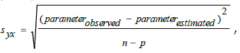
where n is the number of observations and p the number of the parameters of the model. The main goal of these equations was to determine in which way each forest stand parameter could be predicted, so the model that presents the lowest estimation standard error was the one selected.
To validate each selected model, data from 40 plots was used, collected by ARANHA (1998), from the same study area.
Results
The Pinus pinaster stands age span from 11years to 54 years old (Table 1). This is an area with a relative low quality, if we note that at 35 years old the average height is only 16.2m.
Table 1 – The main dendrometric characteristics of the Pinus stand
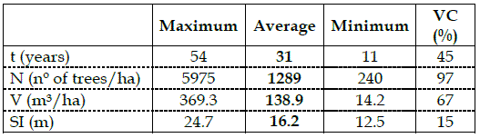
From the analysis of Table 1, it can be seen that the forest stands are very heterogeneous, as proved by the great spread of the variation coefficient (VC), even if in this area they seem to be more homogeneous, as previously reported. This is especially relevant in the number of trees by hectare, with the youngest stands presenting high density and with some of the oldest having very low density. This latter situation poses a problem for this type of work, especially because of the huge contribution of background reflectance to the global reflectance of these areas.
Table 2 summarizes the correlations between dendrometric variables and reflectance in the seven bands of Landsat TM imagery. For a freedom degree of 42, the correlation coefficient is significant for a level of 0.385 and 0.289, respectively for a 0.01 and 0.05 probability.
Table 2 - Pearson Correlation between dendrometric variables and average reflectance over the 7 bands of the Landsat TM imagery
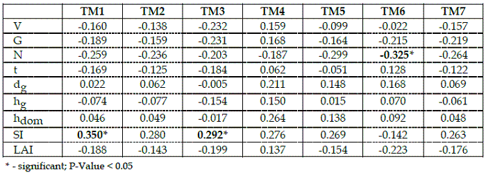
As Table 2 shows, dendrometric variables do not generally present a significant correlation with individual band reflectance, except for the correlation between the site index and the blue wavelength (TM1 band). It is also important to mention that according to RIPPLE et al. (1991) and TROTTER et al. (1997), volume presents negative correlations with all the other bands (even if as in this actual case they are not significant), except with near infrared.
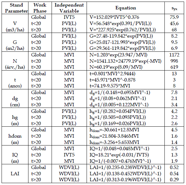
Table 3 presents only the two vegetation indices best correlated with each stand parameter analysed and the best prediction model are presented in Table 4. In Table 4, the column "Global" represents results from the first adjusting step, when all the data were used. Columns "t<20" and "t>20" are related to partial results from the second step, when data was divided into two age classes.
Table 3 – Pearson correlation between the two vegetation indices better correlated and each forest stand parameter
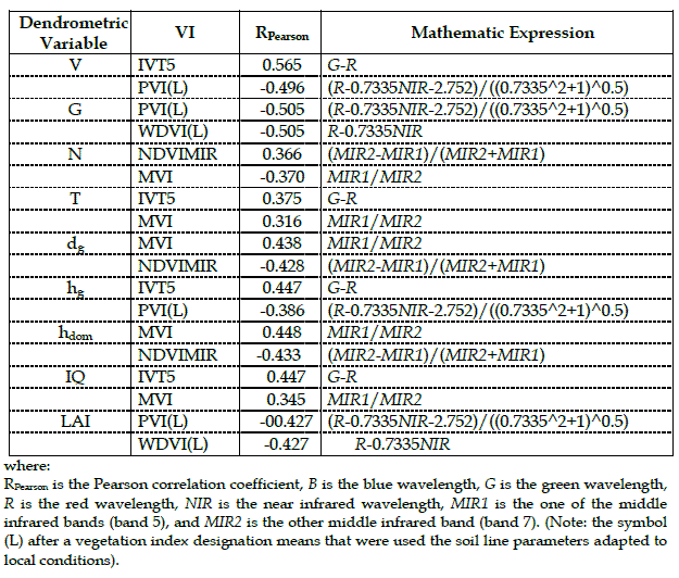
Table 4 - Some of the best prediction models for each dendrometric variable
The results of this study allows us to conclude that vegetation indices are good independent variables for predicting models of forest stand characteristics (Table 3), when comparing with reflectance values of individual bands (Table 2). Although, the obtained results also allow us to conclude that vegetation indices should be chosen rigorously. As a vegetation index stabilises reflectance and limits the interference of disturbing factors, there is the idea that any of them can be used in all cases. For example, NDVI is commonly used because it is one of the most disclosed but in this study NDVI was not even selected as one of the best vegetation indices, for any of the parameters analysed (Table 3).
Data from 49 plots were used to validate prediction models, for each stand parameter (LOPES, 1999). Field data collection and spectral signatures were taken in 1995 in the same region, but over a larger area. The satellite image used was also a Landsat TM. The results presented in Figure 1 coincide with those obtained during the adjustment.
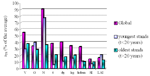
Figure 1 – Standard error deviation, in percentage of the average value for each variable, obtained from the validation stage
When analysing the best prediction models for each dendrometric variable (Table 4), it can be observed that the worst results were found for the volume per hectare. Even the data division in two age groups has not changed this behaviour. All volume prediction models presented correlation coefficients less than 0.350, which is inferior to the results presented by RIPPLE et al. (1991) (-0.55; 0.76) and ARANHA (1998) (0.76).
Basal area had the similar low correspondence as volume per hectare, even with the division of the data into two main age groups.
Also the results obtained for the leaf area index were not encouraging, if compared with the expectations presented in the literature review (ARANHA, 1998; BOUMAN, 1992; DE WULF et al., 1990; ZARATE-VALDEZ et al., 2012). These weak results could be explained by LAI heterogeneity of the forest stands, and also the small, irregular and low density crop, allowing for the interference of disturbance factors, such as soil, shrubs and herbaceous stratums, in the final reflectance captured by the sensors. When studding the effects of soil type and plant architecture on Lai estimation from remotely sensed data, DARVISHZADEH et al. (2008) confirmed that the spectral contrast between leaves and soil background determines the strength of the LAI-reflectance relationship. According to them, in general, the relationship between LAI and VIs was deemed to be stronger in light soil than in dark. The results suggest that, when using remote sensing Vis for LAI estimation, not only is the choice of VI of importance but also prior knowledge of plant architecture and soil background. In this case, the structure of this Pinus species is very challenging as it is a heterogeneous and open crown, thus allowing the influence of soil and shrubs background. This was not analysed in this study and perhaps a better understanding of this would allow to improve these results.
Conclusions and final comments
As shown in the results section above, it is possible to conclude that the more limited results were obtained for the volume, the basal area and the number of trees per hectare. The best results were obtained in the estimation of the site index, average age and average height.
Nevertheless, for the best estimations, it is always possible to discuss if whether the results reached are enough to estimate dendrometric parameters using Landsat TM satellite imageries. The issue depends only on each case and its specific objectives.
Even without being as pessimistic as DE WULF et al. (1990), who said it is unrealistic to expect that digital satellite data will routinely serve to directly infer forest inventory parameters with high accuracy, it is not possible to be excessively optimistic, yet. The fact is that for the general conditions of the Portuguese forest nobody could expect that satellite images could be used, with high accuracy on that they could totally substitute for the traditional forest inventories. The main fact why this work area was chosen was because of its apparent homogeneity, which has been denied by fieldwork collection. The heterogeneity of this study area is common to all Portuguese forests.
In conclusion, it is important to say that research in remote sensing should increase in order to test new technologies, new vegetation indices and to better understand the spectral behaviours of forest species, as well as the possibility of using new images. The new recently available satellite programs, with better spatial resolutions, as predicted by FRITZ (1996), as well as the recent development of new satellite correction technologies, as mentioned by ROY et al. (1997), or the improvement of new methods, like the ones described by HERNÁNDEZ et al. (2012) may represent new encouragement and indicate ways to improve research investigations.
Perhaps in the near future it will be possible to became more optimistic than DE WULF et al. (1990) and that remote sensing data will be used in a routine and precise way, providing accurate data estimations, like AHMED et al. (2011), also perspectivate.
References
AHAMED, T., TIAN, L., ZHANG, Y., TING, K.C., 2011. A review of remote sensing methods for biomass feedstock production. Biomass and Bioenergy 35(7): 2455-2469. [ Links ]
ARANHA, J.T., 1998. An Integrated Geographical Information System for the Vale do Alto Tâmega (GISVAT). Thesis for the Degree of Doctor of Philosophy, Kingston University, 327 pp. [ Links ].
BARET, F., CLEVERS, J.G., STEVEN, M.D., 1995. The Robustness of Canopy Gap Fraction Estimates from Red and Near-Infrared Reflectances: A Comparison of Approaches. Remote Sensing of Environment 54: 141-151. [ Links ]
BAULIES, X., PONS, X., 1995. Approach to Forestry Inventory and Mapping by Means of Multi-Spectral Airborne Data. International Journal of Remote Sensing 16(1): 61-80. [ Links ]
BOUMAN, B.M., 1992. Accuracy of Estimating the Leaf Area Index from Vegetation Indices Derived from Crop Reflectance Characteristics: a Simulation Study. International Journal of Remote Sensing 13(16): 3069-3084. [ Links ]
BROCKHAUS, J.A., KHORRAM, S., 1992. A Comparison of SPOT and Landsat-TM Data for Use in Conducting Inventories of Forest Resources. International Journal of Remote Sensing 13(16): 3035-3043. [ Links ]
CHAVEZ, P.S., 1988. An improved Dark-Object Subtraction Technique for Atmospheric Scattering Correction of Multispectral Data. Remote Sensing of Environment 24: 459-459. [ Links ]
CHAVEZ, P.S., 1989. Radiometric Calibration of Landsat Thematic Mapper Multispec-tral Images. Photogrammetric Engineering and Remote Sensing 55(9): 1285-1294. [ Links ]
CLEVERS, J.G., 1988. The Derivation of a Simplified Reflectance Model for the Estimation of Leaf Area Index. Remote Sensing of Environment 25: 53-69. [ Links ]
COHEN, W.B., SPIES, T.A., FIORELLA, M., 1995. Estimating the Age and Structure of Forests in a Multi-Ownership Landscape of Western Oregon, U.S.A.. International Journal of Remote Sensing 16(4): 724-746. [ Links ]
COLWELL, J.E., 1974. Vegetation Canopy Reflectance. Remote Sensing of Environment 3: 175-183. [ Links ]
DARVISHZADEH, R., SKIDMORE, A., ATZBERGER, C., WIEREN, S. VAN, 2008. Estimation of vegetation LAI from hyperspectral reflectance data: Effects of soil type and plant architecture. International Journal of Applied Earth Observation and Geoinformation 10: 358-37.
DE WULF, R.R., GOOSSENS, R.E., DE ROOVER B.P., BORRY, F.C., 1990. Extraction of Forest Stand Parameters from Panchromatic and Multispectral SPOT-1 Data. International Journal of Remote Sensing 11(9): 1571-1588. [ Links ]
FASSNACHT, K.S., GOWER, S.T., MACKENZIE, M.D., NORDHEIM, E.V., LILLESAND, T.M., 1997. Estimating the Leaf Area Index of North Central Wisconsin Forests Using the Landsat Thematic Mapper. Remote Sensing of Environment 61: 229-245. [ Links ]
FRANKLIN, J., 1986. Thematic Mapper Analysis of Coniferous Forest Structure and Composition. International Journal of Remote Sensing 7(10): 1287-1301. [ Links ]
FRITZ, L.W., 1996. The Era of Commercial Earth Observation Satellites. Photogram-metric Engineering and Remote Sensing 1: 39-45. [ Links ]
HALL, F.G., PEDDLE, D.R., LEDREW, E.F., 1996. Remote Sensing of Biophysical Variables in Boreal Forest Stands of Picea mariana. International Journal of Remote Sensing 17(15): 3077-3081. [ Links ]
HAMAR, D., FERENCZ, C., LICHTENBERGER, J., TARCSAI, G., FERENCZ-ÁRKOS, I., 1996. Yield Estimation for Corn and Wheat in the Hungarian Great Plain Using Landsat MSS Data. International Journal of Remote Sensing 17(9): 1689-1699. [ Links ]
HÄME, T., SALLI, A., ANDERSSON, K., LOHI, A., 1997. A New Methodology for Estimation of Biomass of Conifer-Dominated Boreal Forest Using NOAA AVHRR Data. International Journal of Remote Sensing 18(15): 3211-3243. [ Links ]
HERNÁNDEZ, C., NUNES, L., LOPES, D., GRAÑA, M., 2012. Data fusion for high spatial resolution LAI estimation. Information Fusion, In Press, Corrected Proof, Available online 26 April. [ Links ]
HORLER, D.N., AHERN, F.J., 1986. Forestry Information Content of Thematic Mapper Data. International Journal of Remote Sensing 7(3): 405-428. [ Links ]
JUSOFF, K., SOUZA, G.D., 1997. Use of Satellite Remote Sensing in Malaysian Forestry and Its Potential. International Journal of Remote Sensing 18(1): 57-70. [ Links ]
LASSERRE, B., CHIRICI G., CHIAVETTA, U., GARFÌ, V., TOGNETTI, R., DRIGO, R., DIMARTINO, P., MARCHETTI, M., 2011. Assessment of potential bioenergy from coppice forests trough the integration of remote sensing and field surveys. Biomass and Bioenergy 35(1): 716-724. [ Links ]
LILLESAND, T.M.W., KIEFER, R., 1994. Remote Sensing and Image Interpretation. 3rd Edition, New York: John Wiley and Sons. 750 pp. [ Links ].
LOPES, D.M., 1999. Avaliação de Parâmetros dendrométricos em povoamentos de Pinus pinaster Ait. a partir de imagens Landsat TM. Master Thesis, Universidade de Trás-os-Montes e Alto Douro, Vila Real. 129 pp. [ Links ].
LOPES, D.M., ARANHA, J.T., WALFORD, N., O'BRIEN, J., LUCAS, N., 2009. Accuracy of remote sensing data versus other sources of information for estimating net primary production in Eucalyptus globulus Labill. and Pinus pinaster Ait. ecosystems in Portugal. Canadian Journal of Remote Sensing 35(1): 37-53. [ Links ]
LUCAS, N.S., 1995. Coupling Remotely Sensed Data to a Forest Ecosystem Simulation Model. Thesis for the Degree of Doctor of Philosophy, University of Wales, Swansea, 375 pp. [ Links ].
NEMANI, R., PIERCE, L., RUNNING, S., BAND, L., 1993. Forest Ecosystem Processes at the Watershed Scale: Sensitivity to Remotely-Sensed Leaf Area Index Estimates. International Journal of Remote Sensing 14(13): 2519-2534. [ Links ]
PALÁ, V., PONS, X., 1995. Incorporation of Relief in Polynomial-Based Geometric Corrections. Photogrammetric Engineering & Remote Sensing 61(7): 935-944. [ Links ]
RIPPLE, W.J., WANG, S., ISAACSON, D.L., PAINE, D.P., 1991. A Preliminary Comparison of Landsat Thematic Mapper and SPOT-1 HRV Multispectral Data for Estimating Coniferous Forest Volume. International Journal of Remote Sensing 12(9): 1971-1977. [ Links ]
ROY, D.P., DEVEREUX, B., GRAINGER, B., WHITE, S.J., 1997. Parametric Geometric Correction of Airborne Thematic Mapper Imagery. International Journal of Remote Sensing 18(9): 1865-1887. [ Links ]
SCHLAEGEL, B.E., 1981. Testing, Reporting, and Using Biomass Estimation Models. Forest Science Institute of Clemson University, In Southern Forest Biomass Workshop New Orleans, Louisiana: 95-112. [ Links ]
SPANNER, M.A., PIERCE, L.L., PETERSON, D.L., RUNNING, S.W., 1990. Remote Sensing of Temperature Coniferous Forest Leaf Area Index - The Influence of Canopy Closure, Undertorey Vegetation and Background Reflectance. International Journal of Remote Sensing 11: 95-111.
TOKOLA, T., PITKÄNEN, J., PARTINEN, S., MUINONEN, E., 1996. Point Accuracy of a Non-Parametric Method in Estimation of Forest Characteristics with Different Satellite Materials. International Journal of Remote Sensing 17(12): 2333-2351. [ Links ]
TROTTER, C.M., DYMOND, J.R., GOULDING, C.J., 1997. Estimation of Timber Volume in a Coniferous Plantation Forest Using Landsat TM. International Journal of Remote Sensing 18(10): 2209-2223. [ Links ]
ZARATE-VALDEZ, J.L., WHITING, M.L., LAMPINEN, B.D., METCALF, S., USTIN, S.L., BROWN, P.H., 2012. Prediction of leaf area index in almonds by vegetation indexes. Computers and Electronics in Agriculture 85(July): 24-32. [ Links ]
Entregue para publicação em abril de 2007
Aceite para publicação em dezembro de 2012
