


Serviços Personalizados
Journal
Artigo
 Inglês (pdf)
 Artigo em XML
 Referências do artigo
 Enviar este artigo por email
Indicadores
-
 Citado por SciELO
 -
 Acessos
Links relacionados
-
 Similares em
SciELO
Similares em
SciELO
Compartilhar

 Permalink
Finisterra - Revista Portuguesa de Geografia
versão impressa ISSN 0430-5027
Finisterra no.111 Lisboa ago. 2019
https://doi.org/10.108055/Finis16456
ARTIGO ORIGINAL
Spatial patterns of access to retail food outlets in Mexico city
Padrões territoriais de acesso ao retalho alimentar na cidade do México
Modèles spatiaux d'accès aux points de vente alimentaires de détail dans la ville de Mexico
Patrones espaciales de acceso al comercio minorista de alimentos en la ciudad de México
Ana Laura González-Alejo1, Enrique Propin Frejomil2, Ana Rosa Rosales-Tapia3
1Posgrado en Geografía, Universidad Nacional Autónoma de México, Unidad de Posgrado, edificio G, Circuito de Posgrados s/n, Ciudad Universitaria, Coyoacán, 04510, Ciudad de México, México. E-mail: analgleza@comunidad.unam.mx
2 Investigador, Instituto de Geografía do Departamento de Geografía Económica, Universidad Nacional Autónoma de México, Ciudad de México, México. E-mail: propinfrejomil@igg.unam.mx
3 Investigadora, Instituto de Geografía, Laboratorio de Análisis Geoespacial, Universidad Nacional Autónoma de México, Ciudad de México, México. E-mail: anarosa@igg.unam.mx
ABSTRACT
Trade liberalization in Mexico from 1980 extended the domain of forms of modern supply, as well as stagnating modalities of traditional supply; however, the uneven growth of these supply forms has generated territorial inequalities. This article aims to identify patterns of access to food retail and its association with urban marginalization in Mexico City from a spatial perspective. In the first part, a conceptual revision of the food deserts is presented as an approach through which territorial disparities are recognized in relation to, not only physical access, but also economic limitations that make it impossible for people to move to centres of consumption, restricting them to spaces within their proximity. In the second part, particularities are scrutinized, regarding the urban structure of Mexico City, which influence the differentiated distribution of the types of food supply. Subsequently, a methodological strategy is presented for the delimitation of areas with differentiated proximity to points of sale of fresh and processed foods from a mobile focal reference point, applied in territories with different levels of urban marginalization. Finally, the patterns of access to retail food establishments are revealed. These manifest themselves as large areas of the centre, north and east of the city, exposed to an unhealthy food environment, while the peripheral areas of the west, south and southeast are under the influence of food deserts.
Keywords: Food access; retail food environment; food spatial disparities; food deserts; Mexico.
RESUMO
A liberalização do comércio no México desde 1980 ampliou o domínio das modernas formas de distribuição, bem como a estagnação do tecido comercial tradicional, o que gerou desigualdades territoriais. Este artigo tem como objetivo identificar padrões de acesso ao comércio alimentar e a sua associação com a marginalização urbana na Cidade do México, reconhecendo que as disparidades no território se manifestam a partir de uma abordagem espacial. Na primeira parte, o artigo apresenta uma revisão conceptual dos desertos alimentares como uma abordagem através da qual as disparidades territoriais espelham, não apenas as limitações ao acesso físico dos estabelecimentos comerciais, mas também as limitações económicas que tornam impossível a deslocação de pessoas para outros centros de consumo, restringindo-as aos seus espaços de proximidade. Na segunda parte é analisada a estrutura urbana da Cidade do México, considerando os factores que influenciam a distribui ção de diferentes tipologias de comércio alimentar. Posteriormente, adoptou-se uma estratégia metodológica para a delimitação das áreas com acesso diferenciado aos estabelecimentos de comércio alimentar, cruzando esta informação com os diferentes níveis de marginalização urbana na Cidade do M éxico. Finalmente, conclui-se que grandes áreas do centro, norte e leste da cidade caracterizam-se pela presença de estabelecimentos comerciais associados à venda de produtos de menor qualidade, enquanto as áreas periféricas do sul e sudeste revelam uma ausência acentuada de estabelecimentos de comércio alimentar.
Palavras-chave: Acesso a alimentos; ambiente de retalho alimentar; disparidades espaciais de alimentos; desertos de alimentos.
RÉSUMÉ
La libéralisation des échanges au Mexique depuis 1980 a élargi la domination des formes modernes d'approvisionnement ainsi que la stagnation des modalités d'approvisionnement traditionnelles; Cependant, la croissance inégale de ces formes d'approvisionnement a généré des inégalités territoriales. Cet article vise à identifier les modèles d’accès au commerce de détail alimentaire et son association avec la marginalisation urbaine dans la ville de Mexico, à partir d’ une approche spatiale. Dans une première phase, un cadre conceptuel des déserts alimentaires est présenté comme une approche par laquelle les disparités territoriales sont reconnues en ce qui concerne non seulement l’accès physique, mais aussi les contraintes économiques qui entravent la mobilité des personnes vers les centres de consommation et les limitent à leurs espaces de proximité. Dans la deuxième partie, nous examinons les particularités de la structure urbaine de la ville de Mexico qui influent sur la distribution de différent types de commerce alimentaire; ensuite, une stratégie méthodologique est adoptée pour délimiter des zones d’accè s différencié aux points de vente d'aliments frais et transformés, en croisant cet information avec les différents niveaux de marginalisation urbaine. Enfin, les modè les d’accès aux établissements d’alimentation de détail sont présentés. Ceux-ci se manifestent dans de vastes zones du centre-ville, du nord et de l'est de la ville, exposées à un environnement alimentaire de pauvre qualité, tandis que les régions périphériques du sud et du sud-est sont sous l´influence des déserts alimentaires.
Mots clés: Accès alimentaire; l´environnement alimentaire de détail; les disparités spatiales alimentaires; déserts alimentaires.
RESUMEN
La apertura comercial en México a partir de 1980 extendió el dominio de las formas modernas de abastecimiento de alimentos, así como el estancamiento de las modalidades de abastecimiento tradicional; sin embargo, el crecimiento desigual de estas formas de abastecimiento ha generado desigualdades en el territorio. Este artículo tiene como objetivo identificar los patrones de acceso al comercio minorista de alimentos y su asociación con la marginación urbana en la Ciudad de México, desde una perspectiva espacial. En la primera parte, se presenta una revisión conceptual de los desiertos alimentarios como un enfoque a través del cual se reconocen las disparidades territoriales con relación, no solo al acceso f ísico, sino también a las limitaciones económicas que imposibilitan la movilidad de las personas a los centros de consumo y que los restringe a sus espacios de proximidad. En la segunda parte, se escudriñan las particularidades relacionadas con la estructura urbana de la Ciudad de México que influyen en la distribución diferenciada de los tipos de abastecimiento alimentario. Posteriormente, se presenta una estrategia metodológica para la delimitación de las áreas con proximidad diferenciada a puntos de venta de alimentos frescos y procesados, desde un punto focal móvil de referencia aplicado en territorios con diferentes niveles de marginalidad urbana. Finalmente, se revelan los patrones de acceso a establecimientos minoristas de alimentos. Estos se manifiestan como grandes áreas del centro, norte y este de la ciudad, expuestas a un entorno alimentario poco saludable, mientras que las áreas periféricas del oeste, sur y sureste están bajo la influencia de los desiertos alimentarios.
Palabras clave: Acceso a los alimentos; ambiente alimentario del comercio minorista; disparidades espaciales de alimentos; desiertos alimentarios.
I. INTRODUCTION
Since the 1990s, there has been growing interest in recognizing how spatial availability and access to food is associated with diet (Donkin, Dowler, & Stevenson, 1999; Morland, Wing, & Diez-Roux, 2002; Apparicio, Cloutier, & Shearmur, 2007) and the increase in morbidity rates due to cardiovascular and chronic non-communicable diseases related to nutrition (Wrigley, 2002; Smoyer-Tomic et al., 2008; Truchero, 2015). Mexico, like other countries of emerging economies, has experienced a change in food patterns since the commercial and financial liberalization experienced in the second half of the 1980s. Trade agreements with the United States, the world's leading agri-food economy, implied changes in the productive and market structure (Romero & Ch ías, 2000), as well as an increase in the consumption of proteins, carbohydrates, sugars, saturated fats and other processed food in detriment to the consumption of traditional farm products (Olmedo, 1986; Santos, 2014; Gálvez, 2018).
In Mexico, this transition was followed by one of the fastest increases in mortality from diabetes mellitus type 2 in the world, which went from the ninth cause of mortality, in 1980, to the second, in the year 2010 (Rivera et al., 2012). In urban contexts, such as Mexico City, the problems related to distribution and proximity to food have been analysed from a productivist perspective, particularly from rural development, whose responses have been linked to urban agriculture and food security (McEntee, 2009; Battersby, 2012). Recently, the application of methodologies for the identification of disparities was highlighted, through the concepts of food environments regarding food retail (Lytle & Sokol, 2017; Mahendra, et al., 2017; Wilkins, Morris & Radley, 2017; Bilal et al., 2018), food deserts (Cummins & Macintyre, 1999; Clarke, Eyre, & Guy, 2002; Wrigley, 2002; Guy & David, 2004; Shaw, 2006; Larsen & Gilliland, 2008), food swamps and food oases. Food deserts are defined as “areas of relative exclusion where people experience physical and economic barriers to accessing healthy food” (Reisig & Hobbiss, 2000, p. 138). They are defined as factors by which the population has difficulty eating fresh foods occurring especially in countries with medium and high income whose stage of nutritional transition is at an advanced or intermediate stage, as in the Mexico´s case (Rivera et al., 2012). In contrast to this concept, food oasis is a territory with the best possible access to fresh foods for a healthy diet (Walker, Butler, & Kriska, 2010b; Krian, Bilkova, & Kita, 2015). Currently, due to the high prevalence of obesity among the world population, the usefulness of these concepts is discussed in the face of scenarios where there is a large availability of energy-dense foods that saturates the supply of fresh and healthy products such as fruits, vegetables, seeds and meat (Rose et al., 2009), this type of space is recognized under the concept of food swamp (Saunders, Saunders, & Middleton, 2015; Hager et al., 2016).
Much of this discussion and research has been carried out in Anglo-Saxon countries, such as Great Britain, the United States, Canada and Australia (Bridle-Fitzpatrick, 2015) whose social, cultural and economic characteristics obtain results that can hardly be transferred to the urban context of Mexico City. However, these studies may spawn new assumptions about the conditions of food availability in cities of countries with emerging economies such as Mexico and other Latin American countries, where the modalities of modern trade coexist with other forms of traditional commerce such as public markets, street markets, and informal mobile micro-commerce. This type of traditional trade is mostly oriented and dispersed among the population of low socioeconomic levels, while its modern and transnational counterpart registers a growing homogenization and territorial expansion when located in popular areas with high poverty rates, and areas of great economic affluence. (Duhau & Giglia, 2007; Ayala & Castillo, 2014).
These forms of supply are structured differently. Traditional food supply is organized around a central wholesale market, where food products arrive from all regions of the country and other parts of the world and, from here, are redistributed to the different points of sale in the urban area of Mexico City. On the other hand, modern supply is associated with an open economy model, imposed from the commercial opening of the 1980s and is controlled by a competition system based on the demand for food through commerce firms. They are characterized by relying on regional collection points that simplify the processes of distribution and marketing of food and by leaving out the Central de Abastos for their acquisition.
The methodological experiences in relation to the identification and evaluation of food retail environments have been oriented in five main aspects: 1) the quality, variety and price of the products, 2) the types of stores, 3) the perception of the population, 4) spatial accessibility and 5) mixed methods (Walker, Keane, & Burke, 2010a; Wilkins et al., 2017). The use of Geographic Information Systems (GIS) is noteworthy, especially to address the geographical and spatial nature of disparities in access and proximity to food through the calculation of densities, distances and the identification of clusters in the territory (Larsen & Gilliland, 2008; Gordon et al., 2011; Leete, Bania, & Sparks-Ibanga, 2012). Bridle-Fitzpatrick (2015) has already shown the association between food environments with high densities of processed food and beverages, with high caloric content, and obesity in populations with unfavourable socioeconomic conditions in a Mexican city. However, in the case of Mexico City, there is a lack of studies focused on the analysis of geographical access to food through spatial analysis.
The application of the food deserts methodology has faced problems of consensus in relation to the criteria that are chosen to identify them. On the one hand, the food groups that make up a healthy diet and the types of establishments that offer them have not been defined. Some investigations have considered supermarkets as the best suppliers of varied, healthy and economic foods (Ramos, 2015), while other studies have shown the supply capacity of small and medium-scale trade for population groups (Bilal et al., 2018). Others, on the other hand, have questioned the suitability of supermarkets as suppliers of healthy foods due to the tendency to offer low nutritional foods (Horst, Raj, & Brinkley, 2016). These marked theoretical-methodological differences have limited the comparative possibilities between different studies applied in urban contexts (Ramos, 2015). In addition, no specific distance thresholds have been defined to determine physical access to food supply centres. However, measurements have been made in relation to the density of stores in defined radios of proximity of up to 2 000m (Donkin et al., 1999) as well as the variety of commercial chains and the types of stores in specific areas (Cummins & Macintyre, 1999; Apparicio et al., 2007). In addition to utilizing income as a marker to recognize the economic restrictions of the population to acquire food, other indicators of exclusion, poverty and social deprivation were incorporated (Donkin et al., 1999) as well as to the analysis of consumer prices through qualitative methods for the collection of information (Cummins & Macintyre, 2002; Clarke et al., 2002). Methodological dissimilarities have also yielded contrasting results that make it difficult to compare between different studies whose objectives are to recognize spaces with limited access to healthy foods, as well as populations in conditions of social and economic vulnerability that limit their ability to purchase food for a healthy diet.
For the purpose of recognizing these territories, a methodological model of quantitative character is applied to measure geographical proximity and identify the different retail food environments according to the food supply in distances of 300, 500 and 1 000m2 obtained from the application of the moving windows method for spatial analysis, as well as its variations in relation to the marginalization levels of the population in Mexico City.
II. STUDY AREA AND DATA SOURCES
For the application of the methodology it is necessary to recognize areas with different socioeconomic conditions related to income in order to reveal retail food environments in relation to access and distribution of food in the urban context, In this circumstance, Mexico City represents a territory of great heterogeneity and complexity that is characterized by its economic and social diversification, urban growth, the coexistence of a great variety of consumer markets and a growing economic and spatial segregation (Romero & Chías, 2000).
Mexico City is located within a lacustrine basin with mountain ranges to the east, south and southwest, and a valley that extends through the centre and east of the city (Zamorano & Quijada, 2016). It is a polycentric urban site with the presence of several commercial and business urban subcenters (Graizbord & Acuña, 2004). These include Santa Fe to the west of the city where you will find the headquarters of transnational corporations, luxury homes and shopping centres. Then to the east there is the Central de Abastos de Iztapalapa, where the largest wholesale food trade activity in the world is concentrated. In addition to this, a central district dominated by the presence of the Historic Centeri. This is a traditional commercial area that maintains its economic, cultural and political dynamism within the structure urban with “the presence of 12 public markets, 7 000 economic units and approximately 6 000 street vendors, where almost 200 000 users and 30 000 workers go daily” (Gasca, 2016, p.31).
The historical concentration of commercial and industrial activities has encouraged the expansion of the city and the growth of its population (Huitrón, 2003), which is currently the largest and most important urban area in the country. Delgado (1988) classifies the process of urban growth within Mexico City in contours of conurbation and an inner city (fig. 1). The latter is conformed by the central territorial demarcations of Cuauhtémoc, Miguel Hidalgo, Venustiano Carranza and Benito Juárez. The industrial boom in the north of Mexico City led to the expansion of the urban area (Suárez, 2007) and the formation of the first contour of conurbation between the years 1930-1950 that integrated the territorial demarcations of Gustavo A. Madero and Azcapotzalco, in the north; Coyoacán in the south; Iztapalapa and Iztacalco to the east and Álvaro Obregón in the west, where settled families of workers and the middle class that were integrated into the economic dynamics of the city (Sánchez & Díaz-Polanco, 2011).
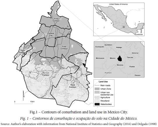
Although the south of Mexico City was not involved in the industrial dynamic, the urban expansion extended, between 1950 and 1970, to the mayor ships of Magdalena Contreras, Tlalpan and Xochimilco. These territorial demarcations have a strong presence of indigenous peoples and communities that they were gradually absorbed by the urban sprawl in the conformation of the second contour of the conurbation. Later, between 1970 and 2000, there was an accelerated advance of the urban sprawl on the Suelo de Conservación Ecológica (Ecological Conservation Land), where eventually irregular housing units and settlements generated a chaotic and disorganized urbanization process. At the same time, there has been a decrease in the demographic growth rates in the central territorial demarcations. This is accompanied by an increase in the urban area of Mexico City, which implies a dynamic of internal population mobility, as well as a re-functionalization of the central area and its tertiarization (Huitrón, 2003; Sánchez & Díaz-Polanco, 2011).
Given that the city expands physically, part of peri-urban agriculture disappears to meet the high demand for housing, industrial, service and leisure areas. In the territorial demarcations of Tlalpan, Xochimilco, Milpa Alta and Tláhuac, small niches continue to be maintained for agricultural production, mainly of vegetables, although they are insufficient for the consumption of the population of the city.
These characteristics and the registered differences in this territorial unit, are of interest for research that seeks to recognize the territorial disparities that affect the availability of food for the population of Mexico City, specifically for those who inhabit areas of urban marginalization.
For the design of a methodology that seeks to reveal the differences in food access in a territory, it is necessary to have statistical information related to the economic units of the food retail outlets for their specific location in the territory. In this regard, the National Institute of Statistics and Geography (INEGI) has the National Statistical Directory of Economic Units (DENUE), updated until the year 2017, which accounts for all commercial establishments for the sale of food, its spatial location and its main characteristics.
It is necessary to mention that the informal trade of fruits and vegetables was not considered due to the lack of statistical information. This along with the impossibility of carrying out data surveys on a scale that covers the entire territory of Mexico City in a context of varying periodicity according to its mobile conditionii.
To recognize the economic limitations of inhabitants of Mexico City regarding food, it is essential to know the levels of income, or the social and economic limitations that generate conditions of disadvantage or vulnerability for the population. In this way, it was decided to use de Urban Marginalization Degree (UMD) of 2010 at the level of the Basic Geostatistical Area (AGEB)iii of the National Population Council (CONAPO), which synthesizes socioeconomic deficiencies in the urban population (CONAPO, 2012).
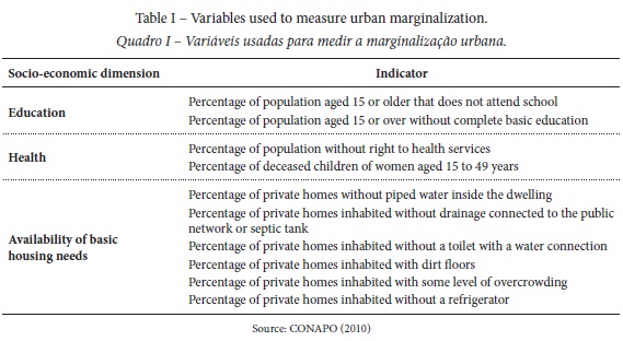
The population in situation of marginalization faces the lack of social opportunities, deprivations and limitations regarding the accessibility of goods and services that are fundamental for well-being, such as food (CONAPO, 2012). To identify the intensity of the deficiencies faced by the population, CONAPO created the Urban Marginalization Index, based on ten indicators that describe three socioeconomic dimensions: education, health and housing, as shown in table I.
III. METHOD
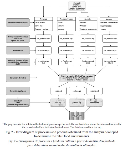
Through the DENUE data, the presence and specific location of commercial establishments oriented to retail food marketing in Mexico was recognized. Table II shows the category assigned to each set of subtypes of commercial establishments according to the products offered to the consumer for the creation of four analysis vector layers and three different food retail environmentsiv (fig. 2).
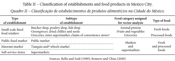
According to the observation of Helbich, Schadenberg, and Hagenauer (2017), Lucan, Karpyn, and Sherman (2010) and Jetter and Cassady (2006), it was considered that the convenience and grocery stores do not represent consumption options for obtaining fresh products such as fruits, vegetables and meat. This results from the limited variety they can offer, or because of the inability to store these products that restricts their sale in this type of establishment.
For data standardization on the specific location of the diverse types of retail food outlets and the socioeconomic conditions of the population, a vector grid of 100x100m was used as a spatial reference. This level of aggregation made it possible to avoid the modifiable area unit problem (MAUP) referring to spatial interpretation effects that are generated when using administrative areas (Shaw, 2012; Helbich et al., 2017).
Through a function of spatial union, the vectorial attributes of the various categories were associated with the grid so that each cell acquired as a value the number of commercial establishments per hectare. The vector maps of each category were rasterized to perform a moving windows analysis (table III), which adds the values of the cells immediately adjacent to a specific focal point in user-defined rectangles of 300, 500 and 1 000m (Tomlin, 1990; Kröger, Khomo, & Levick, 2009).
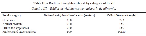
These ranges of distance were selected in accordance with estimations made by other authors in relation to the optimal walking distances in proximity studies of food commerce (Donkin et al ., 1999; Shaw, 2006; Apparicio et al., 2007; Díez et al., 2016). Local data indicate that 40.8% of urban trips made with the intention of obtaining goods and services, are done walking with an average duration of 20 minutes (Lozano et al., 2018), translating into distances that do not exceed 1 000m. On the other hand, Duhau and Giglia (2007) in their study on consumption practices in Mexico City, conclude that with respect to supermarkets and self-service stores, people choose, in a dominant manner, the closest options at home. This is due to mobility difficulties, “much higher than those demanded in urban contexts with more efficient transport and mobility systems” (Duhau & Giglia, p. 31).
The operation of the moving windows allows recognizing the limits of influence exerted by the several types of food trade in each area with a detailed level of analysis for the territory of Mexico City.
Identification of retail food environments
Areas that met certain criteria in relation to food supply were recognized in order to identify different retail food environments in the territory. It was considered that to define an area with presence of fresh food, it should contain commercial establishments providing animal protein, fruits and vegetables and / or markets and supermarkets, whose result was designated as a food oasis. To recognize territories with a low nutritional level, the food retail outlets with presence of processed and industrialized products were considered. Finally, to identify the areas with non-existence or limited availability of fresh foods for the population, it was thought that this did not have premises with fruits and vegetables, animal protein, markets and supermarkets, representing a food desert. Based on these results, generated polygons were joined to the vectorial attributes of the Urban Marginalization Degree by AGEB to distinguish the retail food environments where the socioeconomic characteristics of the population represented an economic and social limitation to obtain food. This would allow identifying populations in conditions of vulnerability, either due to a lack of fresh food or exposure to junk food, which, according to Lucan, Karpyn, and Sherman (2010) and Hilmers, Hilmers, and Dave (2012), is related to the prevalence of obesity and the intake of an unhealthy diet.
The described spatial model implemented the joint use of the Geographic Information Systems ArcGIS 10.1, and its extension of spatial analysis, focal statistics, and QGIS2.18 for vectorial extraction, the creation of raster and spatial joins.
IV. RESULTS
1.Distribution of type of establishments
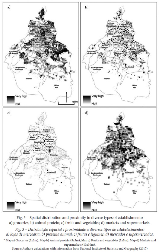
For the year 2017, there were 72 582 food retail outlets in Mexico City. From these 61.1% represent groceries, convenience stores and other establishments whose offer is characterized by the sale of processed and industrialized foods. Meanwhile, 38.9% are represented by establishments with fresh food. To recognize its importance, its spatial distribution and its area of influence, each type of food store was located as a point and a focal statistic was applied according to the type of establishment, using windows of cells of 3x3 (300m), 5x5 (500m), and 10x10 (1 000m).
Figure 3 shows that the coverage of groceries is greater than any other type of food retail, even though only a radius of distance of 150m was considered from the location point of each store. According to Rello and Sodi (1989) and Romero and Chías (2000), markets and supermarkets have superior areas of spatial influence to other types of food trade, so for this study a radius of 500m (1 000m diameter) was considered, which was enough to cover extensive areas of the territory of Mexico City. Differently, the results show a lower importance of the supply of fruits, vegetables and meats compared to the coverage and spatial influence of industrialized and processed foods, which offers a perspective on the spatial relevance of each type of establishment and its possible influence on food choices of the inhabitants of Mexico City.
2.Retail food environment’s description
The distribution of the retail food environments in Mexico City shows the spatial disparities in the availability of types of food products for the population. According to the selected parameters, 21.9% of the urban area is located in zones with sufficient availability of fresh foods, while 58% of the territory is characterized by the offer of highly processed products through convenience stores and groceries. On the other hand, food deserts constitute the smallest percentage of areas within Mexico City and are located in peripheral and less urbanized areas of the city and occupy 20% of the surface, as shown in table IV.
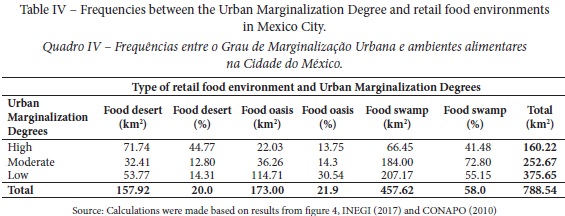
Figure 4 shows a delimitation of areas with different types of proximity to the supply of fresh food and processed products in a range of distance between 0 and 1 000m from a grid of 100x100m. With these results, three types of food retail environments were revealed in Mexico City: deserts, oasis and swamps. In figure 4 it is shown that the deserts are located in the peripheral areas, especially in the south and southeast part of the city, which corresponds to Tlalpan, Xochimilco and Tlahúac.
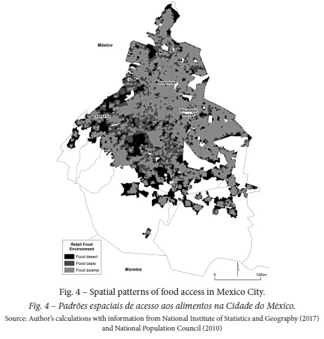
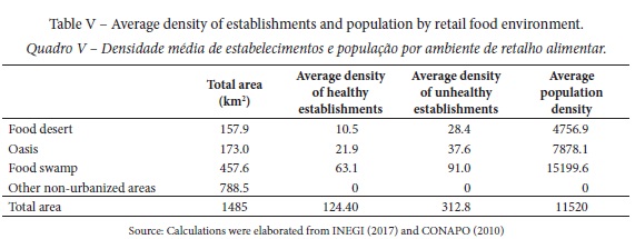
These are peri-urban areas with low population density where their inhabitants are more than 1 000m away from the supply of fresh foods, such as fruits, vegetables, seeds and meat. This type of environment, as expected, registered the lowest density of establishments with food supply. On the other hand, this highlights the presence of food swamps in the north, center and east of the city. In these areas, availability and high density of industrialized and processed products prevails through the retail trade of convenience stores, groceries and miscellanies shops. These establishments make up an extensive area of high density of population that include the territorial demarcations of Benito Juárez, Iztacalco, Cuauhtémoc, Venustiano Carranza and Iztapalapa. In opposition, food oasis covers smaller areas in the south and southwest of the city; specifically, in Coyoacán, Tlalpan, Álvaro Obregón and Miguel Hidalgo, which coincide with residential urban settlements with low population densities, such as it is observed in table V.
3. Exploratory and bivariate analyses
A non-parametric Chi-square test was carried out between the marginalization levels of the population and the types of the retail food environment (p = .001) in order to recognize if the retail food environment is related to the socioeconomic conditions of the population and to disparities in the availability to food in the territory. Subsequently, a Cramer's V correction test showed an average association (.30) between the variables analysed. According to the table of frequencies obtained (table IV), people with a high level of marginalization live in territories where 44.77% of the urban area is limited to physical proximity to fresh food, while 58% of the territory has a supply of processed or industrialized products, which implies that only 21.9% of the city has some form of provision of food that leads to the consumption of a healthy diet. The analysis also revealed that 13.75% of the territory considered as a food oasis, due to its offer of fresh food, is an area with high levels of marginalization, which implies that people face economic barriers in the purchase of food.
When calculating the Pearson coefficient, it was corroborated that there is a bivariate correlation between the population density and the density of industrialized products in the territory (p = 0.01). This means that it is the densely populated areas of Mexico City that register greater presence of this type of retail outlet. When applying a bivariate regression, there was also a negative association between the level of schooling and the density of processed food in the territory (p = .001), which implies that a decrease in the levels of schooling of the population explains a 10.32% increase of the density regarding the convenience and grocery stores in Mexico City.
V. DISCUSSION
As opposed to the food access pattern of developed economies, Mexico City has cultural, economic and social characteristics that influence the type of food supply within the urban area. These conditions are fundamental to explain the differences in relation to other studies of similar scope elaborated in other countries (Díez et al., 2016; Helbich et al., 2017). In US cities there is well-established and consistent evidence to confirm the existence of disparities in access to food to acquire a healthy diet (Díez et al., 2016), especially among low income populations in the inner city and within African Americans and Hispanics groups of people (Moore & Diez, 2006; Kwate, Yau, & Loh, 2009; Walker et al., 2010b; Gordon et al., 2011).
The ethnic and economic segregation that is manifested in the United States, and the differences in the transport and mobility patterns, which are much more oriented to the use of the automobile, differs from the results obtained in some European countries, where the economic gap between the population is lower (Helbich, et al., 2017). In Amsterdam, for instance, where the pattern of mobility is more associated with the use of bicycles and public transport, the results showed little evidence regarding the existence of spatial inequalities in relation to access to food (Helbich et al., 2017).
In the same manner, the research guided by Díez et al. (2016) in Madrid, Spain, highlights the importance of small shops specializing in the supply of healthy foods at short walking distances (200 to 400 m) due to the high density and variety of these establishments in the study territory. This diverges with the results of Anglo-Saxon studies (Great Britain, Canada and the United States), which reflect the value of the presence and spatial distribution of supermarkets (Larsen & Gilliland, 2008; Leete et al., 2012; McKenzie, 2014). This was shown by the studies of Smoyer-Tomic et al. (2008) and Apparicio et al. (2007), who analysed the access to supermarkets in the cities of Edmonton and Montréal, respectively, and found that the low-income population from these cities, has a relatively acceptable access to healthy foods through supermarkets, compared to other studies conducted in the United States.
For Mexico City, the variety, number and type of retail food trade varies significantly in relation to the Anglo-Saxon and Southern European countries (Bilal et al., 2018). This variation occurs since the food supply in the Mexican capital is dominated by the presence of a large number of grocery stores, convenience store chains (Oxxo, 7-eleven, Circle K, among others) and small food stores specializing in fruits, vegetables, seeds and meat. This in addition to public markets, wheels market and tianguis, where the population is supplied with seasonal fruits and vegetables, meat and other fresh products. This wide variety of food offer is also manifested in the territory by the different food retail environments revealed through the application of moving window methodology. Through this methodology, it was found that 21.9% of the urbanized area has sufficient coverage of retail outlets with a healthy food offer at a distance of between 0-500m for specialized fruit, vegetable and meat stores, and between 0-1 000m for markets, supermarkets and tianguis. For Mexico City however, the methodology highlights the population's access to grocery stores and convenience store chains that are close to consumers in ranges of between 0 and 300m for 58% of the urban area of the city. This spatial distribution pattern, known as a food swamp, contributes to the consumption of industrialized foods that induce obesity and overweight among the population (Hilmers et al., 2012; Bridle-Fitzpatrick, 2015).
From the methodological point of view, this work contributed to the knowledge of retail food environments through the use of moving windows analysis in two main aspects: 1) the spatial delimitation of areas with accessibility to different types of food and 2) the detailed local analysis of conditions of food supply at a spatial resolution of 100m2. This methodological perspective allowed for the reduction of the Modifiable Areal Unit Problem (MAUP) that originates inconsistent results due to the way in which the limits of the territorial units are defined. The application of this methodology is a contribution to the understanding of access in urban contexts through the delimitation of areas and a contribution to knowledge of food environments in developing countries, such as Mexico.
VI. CONCLUSIONS
The spatial patterns of access to food retail allow us to recognize that the population faces dissimilar food problems that must be addressed through public policies and intervention of a specific and differentiated nature. The central city and the first contour of conurbation are the ones with the greatest spatial diffusion of food swamps. The second conurbation ring shows a heterogeneous distribution in relation to the presence of deserts and food oasis. The recent urban expansion of peripheral areas of the south of Mexico City is problematic due to the agglutination of unfavourable conditions such as poverty, urban marginalization, the presence of deserts and food swamps within an urban structure where the displacements towards centers of consumption are inefficient in relation to commuting times from the peripheries. This situation exposes the population that inhabits these areas to the conditions of their local food environment and, as indicated by Apparicio et al. (2007), influences purchasing habits as well as the diet of consumers.
The concept of food swamps has been more useful in explaining the prevalence of obesity overweight among the population with medium to low levels of urban marginalization due to the abundant supply of high-calorie foods in detriment of the consumption of healthy foods. The implementation of urban and food projects, action plans in public health and education regarding nutrition strategies can be of great impact in this specific context.
The food deserts expose problems in terms of proximity to the centers of consumption, but also of poverty and marginalization that requires assistance interventions and an improvement in socioeconomic conditions in general. Subsidies provided for the purchase of fresh and healthy products can contribute to the intake of a healthy diet and the improvement in the health conditions of the most vulnerable population groups that inhabit the food deserts.
Subsequent studies can explore the effects on the diet and health of the population when territorial interventions are made, whether public or private, to improve the supply of fresh and healthy food among the inhabitants of Mexico City. The application of surveys and interviews can also be useful to recognize the strategies of the population against unhealthy food environments such as food swamps and deserts.
REFERENCES
Apparicio, P., Cloutier, M., & Shearmur, R. (2007). The case of Montréal´s missing food deserts: evaluation of accessibility to food supermarkets. International Journal of Health Geographics, 6(4), 1-13. doi: https://doi.org/10.1186/1476-072X-6-4 [ Links ]
Asociación de internet.mx. (2018). Estudio de comercio electrónico en México. [E-commerce study in Mexico]. Retrieved from: https://www.asociaciondeinternet.mx/es/component/remository/Comercio-Electronico/Estudio-de-Comercio-Electronico-en-Mexico-2018/lang,es-es/?Itemid [ Links ]
Barrat, J. (1997). The cost and availability of healthy food choices in southern Derbyshire. Journal of Human Nutrition and Dietetics, 10, 63-69. [ Links ]
Battersby, J. (2012). Beyond the food desert: finding ways to speak about urban food security in South Africa. Geografiska Annaler: Series B, Human Geography, 94(2), 141-159. doi: https://doi.org/10.1111/j.1468-0467.2012.00401.x [ Links ]
Bilal, U., Jones-Smith, J., Diez, J., Lawrence, R. S., Celentano, D. D., & Franco, M. (2018). Neighborhood social and economic change and retail food environment change in Madrid (Spain): The heart healthy hoods study. Health & Place, 51, 107-117. doi: https://doi.org/10.1016/j.healthplace.2018.03.004 [ Links ]
Bridle-Fitzpatrick, S. (2015). Food deserts or food swamps?: A mixed-methods study of local food environments in a Mexican city. Social Science & Medicine, 142, 202-213. doi: https://doi.org/10.1016/j.socscimed.2015.08.010 [ Links ]
Clarke, G., Eyre, H., & Guy, C. (2002). Deriving indicators of access to food retail provision in British cities: studies of Cardiff, Leeds and Bradford. Urban Studies, 39(11), 2041-2060. doi: https://doi.org/10.1080/0042098022000011353 [ Links ]
Consejo Nacional de Población. (CONAPO). (2010). Datos abiertos del Índice de Marginación. [Open data of the marginalization Index]. Retrieved from http://www.conapo.gob.mx/es/CONAPO/Datos_Abiertos_del_Indice_de_Marginacion [ Links ]
Consejo Nacional de Población. (CONAPO). (Eds.). (2012). Concepto y dimensiones de la marginación urbana [Concept and dimensions of urban marginalization]. Índice de Marginación Urbana, 2010 (pp. 11-14) México: CONAPO.
Instituto Nacional de Estadística y Geografía. (INEGI). (Eds.). (2017). Directorio Estadístico Nacional de Unidades Económicas. [National Statistical Directory of Economic Units]. Retrived from: http://www.beta.inegi.org.mx/app/mapa/denue/ [ Links ]
Instituto Nacional de Estadística y Geografía. (INEGI). (Eds.). (2018). Encuesta Nacional sobre Disponibilidad y Uso de Tecnologías de la Información en los Hogares . [National Survey on Availability and Use of Information Technologies in Households]. Retrived from: http://www.beta.inegi.org.mx/temas/ticshogares/default.html#Tabulados [ Links ]
Cummins, S., & Macintyre, S. (1999). The location of food stores in urban areas: a case study in Glasgow. British Food Journal, 101(7), 545-553. doi: https://doi.org/10.1108/00070709910279027 [ Links ]
Cummins, S., & Macintyre, S. (2002). A systematic study of an urban foodscape: the price and availability of food in Greater Glasgow. Urban Studies, 49(11), 2115-2130. doi: https://doi.org/10.1080/0042098022000011399 [ Links ]
Delgado, J. (1988). El patrón de ocupación territorial de la Ciudad de México al año 2000 [The patterns of territorial occupation of Mexico City to the year 2000]. In O. Terrazas & E. Preciat (Eds.), Estructura Territorial de la Ciudad de México [Territorial structure of Mexico City]. México: Plaza y Valdez. [ Links ]
Díez, J., Bilal, U., Cebrecos, A., Buczynski, A., Lawrence, R. S., Glass, T… Franco, M. (2016). Understanding differences in the local food environment across countries: a case study in Madrid (Spain) and Baltimore (USA). Preventive Medicine, 89, 237-244. doi: https://doi.org/10.1016/j.ypmed.2016.06.013
Donkin, A. J. M., Dowler, E. A., Stevenson, S. J., & Turner, S. A. (1999). Mapping access to food at a local level. British Food Journal, 101(7), 554-564. doi: https://doi.org/10.1108/00070709910279054 [ Links ]
Duhau, E., & Giglia, A. (2007). Globalización e informalidad en la Ciudad de México. Prácticas de consumo y movilidad [Globalization and informality in Mexico City. Consumer and mobility]. Trace. Travaux et Recherches dans les Amériques du Centre, 51, 28-43.
Gordon, C., Purciel-Hill, M., Ghai, N. R., Kaufman, L., Graham, R., & Van Wye, G. (2011). Measuring food deserts in New York City´s low income neighborhoods. Health & Place, 17, 696-700. doi: https://doi.org/10.1016/j.healthplace.2010.12.012 [ Links ]
Gálvez, A. (2018). Eating NAFTA. Trade, food policies and the destruction of Mexico. California: University of California Press. [ Links ]
Gasca, J. (2016). Comercio y consumo bajo la reestructuración espacial urbana [Trade and consume under urban spatial restructuring]. In J. Gasca & P. Olivera (Eds), Ciudad, comercio urbano y consumo. Experiencias desde Latinoamérica y Europa [City, urban commerce and consumption. Experiences from Latin America and Europe] (pp. 23-50). Mexico City: UNAM. [ Links ]
Graizbord, B., & Acuña, B. (2004). La estructura polinuclear del Área Metropolitana de la Ciudad de México [The polynuclear structure of the metropolitan area of Mexico City]. In A. G. Aguilar (Ed.), Procesos metropolitanos y grandes ciudades. Dinámicas recientes en México y otros países [Metropolitan processes and large cities. Recent dynamics in Mexico and other countries] (pp. 309-328) Mexico City: UNAM. [ Links ]
Guy, C. M., & David, G. (2004). Measuring physical access to healthy foods in areas of social deprivation: a case study in Cardiff. International Journal of Consumer Studies, 28 (3), 222-234. doi: https://doi.org/10.1111/j.1470-6431.2003.00340.x [ Links ]
Hager, E. R., Cockerham, A., O`Reilly, N., Harrington, D., Harding, J., Hurley, K. M., & Black, M. M. (2016). Food swamps and food deserts in Baltimore City, MD, USA: associations with dietary behaviors among urban adolescent girls. Public Health Nutrition, 20(14), 2598-2607. doi: https://doi.org/10.1017/S1368980016002123 [ Links ]
Helbich, M., Schadenberg, B., Hagenauer, J., & Poelman, M. (2017). Food deserts? Healthy food access in Amsterdam. Applied Geography, 83, 1-12. doi: https://doi.org/10.1016/j.apgeog.2017.02.015 [ Links ]
Hilmers, A., Hilmers, D. C., & Dave, J. (2012). Neighborhood disparities in access to healthy foods and their effects on environmental justice. American Journal of Public Health, 102 (9), 1644-1654. doi: https://doi.org/10.2105/AJPH.2012.300865 [ Links ]
Horowitz, C. R., Colson, K. A., Hebert, P. L., & Lancaster, K. (2004). Barriers to buying healthy foods for people with diabetes: evidence of environmental disparities. American Journal of Public Health, 94, 1549-1554. doi: https://doi.org/10.2105/AJPH.94.9.1549 [ Links ]
Horst, M., Raj, S., & Brinkley, C. (2016). Getting outside the supermarket box: alternatives to food deserts. Urban Studies and Planning Faculty Publications and Presentations, 191, 9-12. [ Links ]
Huitrón, R. (2003). La industria alimentaria en México y su inserción en el mercado moderno de la ciudad de México [The food industry in Mexico and its insertion in the modern market of Mexico City]. (Doctoral thesis). National Autonomous University of Mexico. [ Links ]
Jetter, K. M., & Cassady, D. L. (2006). The Availability and Cost of Healthier Food Alternatives. American Journal of Preventive Medicine, 30, 38-44. doi: https://doi.org/10.1016/j.amepre.2005.08.039 [ Links ]
Krian, F., Bilková, K., Kita, P., & Hornák, M. (2015). Potential food deserts and food oases in a post-communist city: access, quality, variability and price of food in Bratislava-Petralka. Applied Geography, 62, 8-18. doi: https://doi.org/10.1016/j.apgeog.2015.04.003
Kröger, R., Khomo, L., Levick, S., & Rogers, K. H. (2009). Moving window analysis and riparian boundary delineation of the Northern Plains of Kruger National Park, South Africa. Acta Oecologica, 35, 573-580. doi: https://doi.org/10.1016/j.actao.2009.05.007 [ Links ]
Kwate, N. O. A., Yau, C., Loh, J., & Williams, D. (2009). Inequality in obesogenic environments: fast food density in New York City. Health & Place, 15, 364-373. doi: https://doi.org/10.1016/j.healthplace.2008.07.003 [ Links ]
Larsen, K., & Gilliland, J. (2008). Mapping the evolution of `food deserts´ in a Canadian city: Supermarket accessibility in London, Ontario, 1961-2005. International Journal of Health Geographics, 7(16), 1-16. doi: https://doi.org/10.1186/1476-072X-7-16 [ Links ]
Leete, L., Bania, N., & Sparks-Ibanga, A. (2012). Congruence and coverage: alternative approaches to identifying urban food deserts and food hinterlands. Journal of Planning Education and Research, 32, 204-218. doi: https://doi.org/10.1177/0739456X11427145 [ Links ]
Lozano, A, Guzmán, A., Camacho, G., & Miranda, M., (2018). Herramienta 1 para identificar la relevancia de cada modo de transporte [Tool 1 to identify the relevance of each mode of transport]. Instituto de Ingeniería. UNAM. Retrieved from http://giitral.iingen.unam.mx/Estudios/EOD-Estadisticas-03.html [ Links ]
Lucan, S. C., Karpyn, A., & Sherman, S. (2010). Storing empty calories and chronic disease risk: snack-food products, nutritive content, and manufacturers in Philadelphia corner stores. Journal of Urban Health: Bulletin of the New York Academy of Medicine, 87(3), 394-409. doi: https://doi.org/10.1007/s11524-010-9453-5 [ Links ]
Lytle, L. A., & Sokol, R. L. (2017). Measures of the food environment: A systematic review of the field, 2007 2015. Health & Place, 44, 18-34. doi: https://doi.org/10.1016/j.healthplace.2016.12.007 [ Links ]
Mahendra, A., Polsky, J. Y., Robitaille, E., Lefebvre, M., McBrien, T., & Minaker, L. M. (2017). Geographic retail food environment measures for use in public health. Health Promotion and Chronic Disease Prevention in Canada, Policy and Practice, 37(10), 357-362. doi: https://doi.org/10.24095/hpcdp.37.10.06 [ Links ]
McEntee, J. (2009). Highlighting food inadequacies: does the food desert metaphor help this cause? British Food Journal, 111(4), 349-363. doi: https://doi.org/10.1108/00070700910951498 [ Links ]
McKenzie, B. (2014). Access to supermarkets among poorer neighborhoods: a comparison of time and distance measures. Urban Geography, 35(1), 133-155. doi: https://doi.org/10.1080/02723638.2013.856195 [ Links ]
Morland, K., Wing, S., & Diez-Roux, A. (2002). The contextual effect of the local food environment on residents´ diets: the atherosclerosis risk in communities study. American Journal of Public Health, 92(11), 1761-1767. doi: https://doi.org/10.2105/AJPH.92.11.1761 [ Links ]
Moore, L. V., & Diez, A. V. (2006). Associations of neighborhood characteristics with the location and type of food stores. American Journal of Public Health, 96(2), 325-331. doi: https://doi.org/10.2105/AJPH.2004.058040 [ Links ]
Olmedo, B. (1986). Capital trasnacional y consumo. El caso del sistema agroalimentario en México [Transnational capital and consumption. The case of the agri-food system in Mexico]. Mexico City: UNAM.
Reisig, V., & Hobbiss, A. (2000). Food deserts and how to tackle item: a study of one city´s approach. Health Education Journal, 59, 137-149. [ Links ]
Rello, F., & Sodi, D. (1989). Abasto y distribución de alimentos en las grandes metropolis. El caso de la Ciudad de México [Supply and distribution of food in the large metropolis. The case of Mexico City]. Mexico City: Nueva Imagen.
Rivera, J. A., Velasco, A., Hernández, M., Aguilar, C. A., Vadillo, F., & Murayama, C. (2012). Obesidad en México: recomendaciones para una política de Estado [Obesity in Mexico: recommendations for a State policy]. In J. A. Rivera, A. Velasco, M. Hernández, C. A. Aguilar, F. Vadillo & C. Murayama (Eds.), Obesidad en México. Recomendaciones para una política de Estado [Obesity in Mexico: recommendations for a State policy] (pp. 11-41). Mexico City: UNAM. [ Links ]
Romero, S., & Chías, L. (2000). Patrones territoriales de los establecimientos comerciales de la Zona Metropolitana de la Ciudad de México, 1997 [Territorial patterns of commercial services in the Metropolitan Area of Mexico City, 1997]. Investigaciones Geográficas, Boletín del Instituto de Geografía, 42, 134-156.
Sánchez, C., & Díaz-Polanco, H. (2011). Pueblos, comunidades y ejidos en la dinámica ambiental de la Ciudad de México [Peoples, communities and ejidos in the environmental dynamics of Mexico City]. Cuicuilco, 18(52), 191-224.
Santos, A. (2014). El patron alimentario del libre comercio [The food pattern of free trade]. Mexico City: UNAM.
Saunders, P., Saunders, A., & Middleton, J. (2015). Living in a fat swamp: exposure to multiple sources of accessible, cheap, energy-dense fast foods in a deprived community. British Journal of Nutrition, 13, 1828-1834. doi: https://doi.org/10.1017/S0007114515001063 [ Links ]
Shaw, H. J. (2012). Access to healthy food in Nantes, France. British Food Journal, 114(2), 224-238. doi: https://doi.org/10.1108/00070701211202403 [ Links ]
Shaw, H. J. (2006). Food deserts: towards the development of a classification. Geografiska Annaler: Series B, Human Geography, 88(2), 231-247. [ Links ]
Smoyer-Tomic, K. E., Spence, J. C., Raine, K. D., Amrhein, C., Cameron, N., Yasenovskiy, V… Healy, J. (2008). The association between neighborhood socioeconomic status and exposure to supermarkets and fast food outlets. Health & Place, 14, 740-754. doi: https://doi.org/10.1016/j.healthplace.2007.12.001
Suárez, M. (2007). Mercados de trabajo y localización residencial en la ZMCM. (Doctoral thesis) National Autonomous University of Mexico. [ Links ]
Tomlin, D. (1990). Geographic Information Systems and Cartographic Modeling. New Yersey: Prentice Hall. [ Links ]
Truchero, G. (2015). El acceso a la alimentación: el debate sobre los desiertos alimentarios [Access to food: the debate on food deserts]. Investigación & Desarrollo, 23(2), 391-415. doi: https://doi.org/10.14482/indes.23.2.6970
Walker, R.E., Keane, C.R. & Burke, J.G. (2010a). Disparities and access to healthy food in the United States: A review of food deserts literature. Health & Place, 16, 876-884. doi: https://doi.org/10.1016/j.healthplace.2010.04.013 [ Links ]
Walker, R. E., Butler, J. & Kriska, A. (2010b). How does food security impact residents of a food desert and a food oasis? Journal of Hunger & Environmental Nutrition, 5, 454-470. doi: https://doi.org/10.1080/19320248.2010.530549 [ Links ]
Wilkins, E. L., Morris, M. A., Radley, D., & Griffiths, C. (2017). Using Geographic Information Systems to measure retail food environments: Discussion of methodological considerations and a proposed reporting checklist (Geo-FERN). Health & Place, 44, 110-117. doi: https://doi.org/10.1016/j.healthplace.2017.01.008 [ Links ]
Wrigley, N. (2002). Food deserts in British cities: policy context and research priorities. Urban Studies, 39(11), 2029-2040. doi: https://doi.org/10.1080/004209802200001134 [ Links ]
Zamorano, J. J., & Quijada, I. (2016). El relieve de la cuenca de México [The relief of the basin of Mexico]. In A. G. Aguilar (Eds.), La Ciudad de México en el siglo XXI. Realidades y retos. [Mexico City in the 21st century. Realities and challenges] (pp. 27-37) Mexico City: Porrúa. [ Links ]
Recebido: janeiro 2019. Aceite: maio 2019.
NOTAS
iHistoric Downtown currently concentrates specialized trade, generally grouped by streets in which a determined turn prevails, as well as a large number of establishments oriented to satisfy particularly the demand of the popular classes.
iiIt is also important to highlight the relative importance of Internet purchases by consumers in a country such as Mexico. In 2018 it was reported that 18% of purchases by this means were in supermarkets to buy groceries in general (Asociacióndeinternet.mx). It is true that the urban growth and mobility conditions can be overcome through digital commercial practices that facilitate the distribution of food in the territory of Mexico City, particularly in high incomes territories since according to the National Survey on Availability and use of information Technologies in Households (ENDUTIH) (2018), only 0.4% of population of the semi-rural periphery of Mexico City have access to these technologies.
iiiThe “Basic Geostatistical Area” is a territorial division of third category, inferior to the state and municipal geostatistical areas (CONAPO, 2012).
ivThe food environments were defined from the application of Boolean operators to distinguish the spatial behavior of food categories in sets that combine results according to their presence or their non-existence in the territory. The existence of proteins and fresh products, as a whole, or in markets, is considered to identify food oases. Food swamps are defined by the presence of oases in association with groceries, while the deserts are articulated by the absence of any form of supply.

