


Services on Demand
Journal
Article
 English (pdf)
 Article in xml format
 Article references
 Send this article by e-mail
Indicators
-
 Cited by SciELO
 -
 Access statistics
Related links
-
 Similars in
SciELO
Similars in
SciELO
Share

 Permalink
Finisterra - Revista Portuguesa de Geografia
Print version ISSN 0430-5027
Finisterra no.98 Lisboa Dec. 2014
ARTIGO ORIGINAL
Impacts of the storm Hercules in Portugal
Impacto da tempestade Hercules, em Portugal.
Ângela Santos1 Susana Mendes2 João Corte-Real3
1 Centre for Geographical studies, Institute of Geography and Spatial Planning, Universidade de Lisboa, Edifício da Faculdade de Letras, Alameda da Universidade, 1600-214, Lisboa, Portugal. E-mail: angela.Santos@campus.ul.pt
2 Geophysical Institute, University of Bergen, Allegaten 70, 5007 Bergen, Norway and Bjerknes Centre for Climate research, Bergen, Norway. E-mail: susana.Mendes@gfi.uib.no
3 Institute of Mediterranean Agrarian and Environmental Sciences (ICAAM), University of Évora, Évora, Portugal and Department of aeronautics and transports, University Lusófona of Humanities and Technologies, Research Unit Dreams, Lisbon, Portugal. E-mail: jmcr@uevora.pt; joao.cortereal@ulusofona.pt
ABSTRACT
The aim of this study is to analyse the impacts of the Hercules storm in Portugal. The storm occurred from January 5th to 7th, 2014. A brief characterization of the storm was conducted and the witnesses’ accounts were compiled, complemented with field survey before and after the storm. The results show that this event had origin in a strong system of low pressure that hit Portugal. The system triggered strong sea waves with long periods, run-ups between 6 to 9 m, and inundation depths mostly under 1 m. The effects on the Portuguese coastline showed some weaknesses in the spatial planning management: (i) the fact that a wave train restricted to the beaches, front streets, ports and marinas caused significant damage; (ii) some people ignored the emergency management authorities, putting themselves in a risk situation.
Keywords: Hercules storm, media, witnesses’ accounts, field survey, risk awareness.
RESUMO – Neste estudo, analisam-se os impactos da tempestade Hércules, que atingiu Portugal entre os dias 5 e 7 de Janeiro de 2014. Caracteriza-se brevemente a tempestade, e apresentam-se os relatos das testemunhas e os resultados do trabalho de campo anterior e posterior à tempestade. Este evento teve origem num forte sistema depressionário que provocou forte agitação marítima, ondas de longo período, run-ups de 6 a 9 m, com profundidades de inundação em geral inferiores a 1m. Os efeitos no litoral português ilustram algumas fraquezas no ordenamento e gestão do território: (i) o facto de um conjunto de ondas, mesmo restringidas às praias, marginais, portos e marinas, ter causado elevados prejuízos materiais; (ii) a circunstância de os avisos das autoridades da gestão da emergência terem sido ignorados por indiv íduos, que assim se colocaram em situação de risco.
Palavras-chave: Tempestade Hércules, comunica ção social, testemunhos, trabalho de campo, sensibilização ao risco.
RÉSUMÉ
Impacts de la tempête Hercule au Portugal. La tempête “Hercule” a touché le Portugal du 5 au 7 janvier 2014. Pour analyser ses conséquences, on l ’a sommairement caractérisée, on a recueilli divers témoignages et on a observé le terrain, avant et après la temp ête. Ce système dépressionnaire accentué a provoqué une forte agitation maritime, avec des vagues de longue période et de 6 à 9 m d’amplitude. Les dégâts enregistrés révèlent certaines faiblesses de gestion de la part des autorit és : i) il est anormal que des vagues n’ayant touché qu’une étroite bande littorale aient provoqué de tels dég âts matériels; ii) Les avis de danger émis par l’organisme chargé de gérer les situations périlleuses ont été ignorées par certaines personnes, qui ont ainsi couru des risques.
Mots-clés: Tempête “Hercule ”, média, témoignages, travail de terrain, enquête de terrain, sensibilisation aux risques.
I. INTRODUCTION
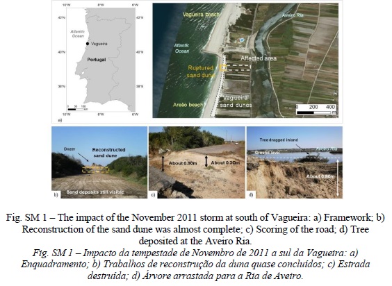
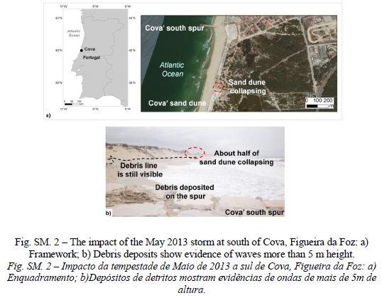
Portugal has been experiencing atmospheric events that caused severe damage and fatalities, such as the floods of 1876, 1967 and 1997 (Zêzere et al., 2014). However, scientific studies focusing on observational perspective are scarce (Sousa et al., 2013) and even fewer studies deal with post-disaster field surveys. Pereira, et al. (2014) pointed out that newspapers are good data providers regarding temporal information about the natural disaster events that caused damage including direct injuries on the populations, as well as economic damage. Thus, field surveys, carried out by the first author, are the best approach to obtain spatial inventories. In 2011 a storm destroyed the sand dunes at the south of Vagueira (fig. SM 1, supplementary Material, available online), damaged a road and reached the Aveiro Ria, which is about 200 m inland. The field survey showed the fast reconstruction of the sand dune, and a scouring of about 0.8 m on the road. Also in 2011, a very rare episode of hail occurred in Lisbon (Fragoso et al., 2011), where data was also collected in situ. Another storm that occurred in 2013 generated waves that reached at least 5 m high in Cova, Figueira da Foz. The debris line was still visible at the base of Cova’s sand dune (fig. SM 2). At that time, there was also large debris deposited on the Cova’s south spur. Although this storm did not cause any damage on the area, evidences were found that a section of the sand dune was collapsing.
Between January 5th and 7th, 2014 a low pressure system approached Portugal from the Atlantic Ocean. It was named “Hercules” by the Weather Channel ( http://www.weather.com/news/weather-winter/winter-stormnames-2013-2014-20131001), which is a media company. However, the official name of this winter storm is “Christina” by the University of Berlin (http://www.met.fu-berlin.de/adopt-a-vortex/tief/). In this paper the “Hercules” name was selected because most of the information related to its impacts was provided by the media. Its passage left significant damage due to strong winds, long period waves and intense precipitation. The most significant impacts occurred on the evening of Monday, January 6th and in the early morning of Tuesday January 7th.
Long sea waves generated by atmospheric disturbances can be caused by atmospheric gravity waves, storm activity, pressure jumps, frontal passages and squalls (Rabinovich et al., 2009; Vilibic and Sepic, 2009). These waves are similar to ordinary tsunami waves and can affect coasts in a similar way. They are usually called meteotsunamis or meteorological tsunamis. Thus, the features of Hercules storm fits well in this type of natural hazards.
The emergency management authorities provided several storm warnings to the general population (Civil Protection, IPMA and the Maritime authority). The warnings were disseminated to the public by the media. In fact, the role of media has been increasing in the dissemination of the information related to natural disasters (Vasterman, et al. 2005; Barnes et al., 2008) not only live, but especially on online archives (Tschoegl et al., 2006; Santos et al., 2007; Santos, 2011; Santos and Queir ós, 2013). The media also played an important role in the dissemination of the witnesses’ accounts by providing videos, photos and reports online. The witnesses’ accounts are very important because among other data allows a comprehensive analysis of a natural disaster (Levine et al., 2004; Tinti et al., 2005). For example, Vucetic et al. (2009) compiled the witnesses’ accounts of the 1978 meteotsunami, in order to put together that event.
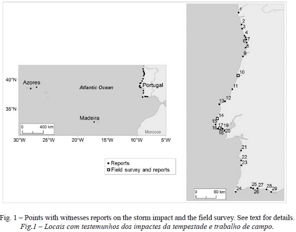
Although the Hercules storm caused damage in the interior of Portugal, the objective of this study was to investigate the impact of the storm on coastal areas of Portugal (fig. 1), with the aim of pointing out the damages on natural systems, structures and infra-structures, as well as fatalities.
In the next section, the methodology is presented, followed by the storm characterization. In section IV, the witnesses’ accounts are collected, complemented by the results of the field survey. Finally, the discussion and conclusions are presented.
II. METHODOLOGY
The methodology applied to this study was based in the following methods: the storm characterization, the compilation and interpretation of the witnesses’ accounts and a post-tsunami field survey. The storm characterization was carried out by the collection of satellite images, forecasted weather maps and tide gauge data.
The witnesses’ accounts were compiled from the media, reporting damages all over the Portuguese coastline that occurred in the evening of January 6th. Most of the reports were broadcasted live on the Portuguese TV channels, on Monday evening (January 6th) and on Tuesday morning (January 7th), and later posted on online archives. The major sources of information used in this study were RTP Notícias online (http://www.rtp.pt), Sic Notícas online (www.sicnoticias.sapo.pt), Porto Canal online (www.portocanal.sapo.pt) and TVI24 online (http://www.TVI24.iol.pt). In addition, daily newspapers also provided important data on their websites: Correio da Manhã online. (http://www.cmjornal.xl.pt), Diário de Coimbra online (www.diariocoimbra.pt) and Região Sul online (www.regiao-sul.pt). The Rá dio Renascença radio station also posted online information about the storm’s impact at Rádio Renascença online (www.rr.sapo.pt). Furthermore, many videos and photos were posted online by the witnesses themselves, which also provided important valuable data.
As a complement to the witnesses’ accounts, a field survey was conducted on some coastal areas. The selection of the studied points were based on existing previous research and field surveys, as well as on availability of post-storm photos. The Hercules storm generated waves of unusual long periods (section III), fitting in the definition of a meteotsunami, causing its behaviour on the coastline as “tsunami like”. therefore, post-tsunami field survey techniques (Borrero, 2005; Imamura et al., 2005; Dominey-Howes et al., 2012) were applied by the first author with the aim of: i) documenting damages on camera, ii) measuring longitude, latitude and height using GPS III) pointing out features of the storm, and iv) measuring maximum water level height and inundation depths on the affected coastal areas.
III. STORM CHARACTERIZATION
On January 5th, 2014 the north Atlantic was under the influence of a deep depression, in the lower troposphere, with a closed nucleus above 40ºn, between the longitudes of 0 to 40ºW, to which was associated an occluded frontal system with a cold front to the West of the Iberian Peninsula extending north, to the UK. At the centre of the depression, located at 50ºn, 30ºW, the pressure at the surface (12:00 UTC) was lower than 940 hPa. The system extended to the south till 30ºn as a cold long wave in the mean sea level pressure field; the associated winds were strong, especially north of 35ºn. The deep vertical structure of the system was associated with wind values that increased with altitude Portugal was under the influence of a shortwave high pressure ridge with advection of warm air. A cold low was located at the Gulf of Genoa in the Mediterranean Sea.
Then, from January 5th to 6th, all the depressionary structure moved to n-ne. The cold frontal surface was (12:00 UTC) on the north and centre of Portugal. The entire country was under the influence of warm air from SW and positive advection of relative vorticity. also, from January 5 th to 6 th, an intensification of the wind was observed, both at surface and aloft; at the 500 hPa level the wind intensity was higher than 50kt.
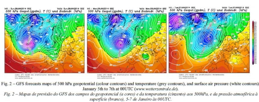
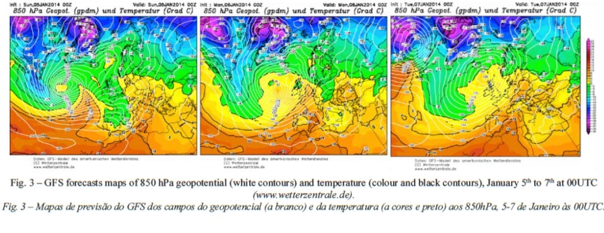
On January 7th, the cold frontal surface mentioned above, was already influencing the south of Portugal, by moving from NW to se. In the middle troposphere, at 500 hPa, over Portugal, an intense positive advection of relative vorticity was associated to wind intensities of 60 to 70 kt. The high pressure ridge that on January 5th was located over Portugal two days later was influencing the Gulf of Genoa. The above mentioned cold low was observed to move to the north of Africa. Furthermore, from January 5th to 7th, over the Atlantic Ocean, the fetch length was large with strong winds from SW. The propagation of this low-pressure system was very well identified by the Global forecast system (GFS) analysis displayed in figure 2 and figure 3.
fig. 2
fig. 3
Finally, on January 8th all the cyclonic structure was in the lower troposphere, over the Atlantic Ocean fragmented. A high pressure ridge of long wavelength between 20ºW and 40ºW was observed. Above Portugal, at the surface, the wind was weak from south, and a new frontal surface was now influencing the country from the NW. At 500 hPa, the long wavelength trough was still observed with warm air advection and positive advection of relative vorticity at 850 hPa and 500 hPa. Although the Hercules storm had completely vanished on January 8th, Portugal still remained under the influence of rainy weather conditions, although not stormy.
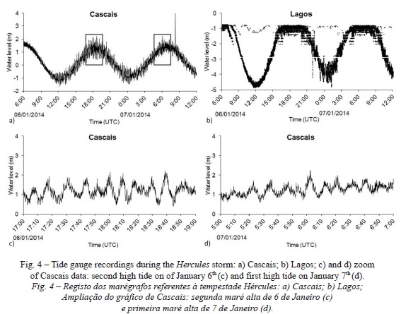
The most significant impacts occurred on the evening of January 6th and in the early morning of January 7th during the high tides. Figure 4 shows the available tide gauge stations that recorded the Hercules storm (www.ioc-sealevelmonitoring.org) in mainland Portugal. Due to the evident unreliability displayed by the data registered at Lagos station, the authors decided to rely on the Cascais data set. The Cascais tide gauge station clearly shows that the maximum water level corresponded to the high tide of the January 6th, about 18:40 (UTC), and in the early morning of January 7th. Data also show clearly long period waveforms of about 10 minutes, a feature also observed in meteotsunami events.
IV. WITNESSES’ACCOUNTS
The location of the points described by the witnesses is presented in figure 1, and table I summarizes the reports. The places are ordered from north to south. The witnesses reported several storm parameters, damages that were separated between damages on natural landscapes, structures and properties, and fatalities.
table I
In Matosinhos (Point 4), four waves were observed, the second and the fourth being the largest ones (PC, 2014c). However, one major wave was responsible for the flooding on the coastal areas of Porto (Point 5), Caldas da Rainha (Point 12) and Tamariz beach, Estoril (Point 17). The witnesses also reported the wave heights, estimated based on their knowledge about the local areas. The wave heights ranged between 5 m in Tamariz beach, Estoril (Point 17) and 9 m height at Furadouro, Ovar (Point 8).
Significant damage was observed along most of the Portuguese shoreline, including Azores, as presented in table I. exceptions occurred in Cortegaça, Ovar (Point 8) where there were no damage or injuries, but the Cortegaça camping site was in danger of being flooded (Bessa and Valentim, 2014). In Madeira, although the waves overtopped the levees, no damage was reported (Fernandes et al., 2014). Although sand dunes are natural barriers these structures did not stand the sea onslaught in several coastal areas such as in Esposende (Point 2), in Ilhavo (Point 9), in Figueira da Foz (Point 10), Costa da Caparica (Point 20), and Praia de Faro, Faro (Point 29).
In some places streets were closed down: at Matosinhos (Point 4) the sea front streets were full of sand and debris, and the traffic was cut between the Liberdade Avenue (av) and Antunes Guimarães Avenue in Leça da Palmeira (near the new Port authorities of Douro and Leixões) and the Almeiriga Norte St., between the Paraíso and Memória beaches, in Perafita (TVI24, 2014c). at Porto (Point 5), the authorities had to progressively increase the safety perimeter (RTPN, 2014d) because people would not stay away from the coastline; in Caldas da Rainha (Point 12) one major wave flooded the Mar Avenue, at the Foz do Arelho beach, dragging away four cars although no injuries were reported. This happened soon after 19:00 hours. Following this, the beach bars and streets were closed to traffic (TVI24, 2014i).
There were no fatalities in Portugal, however around 20 people needed to be rescued in Póvoa do Varzim (Point 3), Porto (Point 5), Furadouro , Ovar (Point 8), Peniche (Point 13), Ericeira (Point 14) and Quarteira (Point 28). In Madeira, several tourists were caught by the waves (Fernandes et al., 2014) while at Paul do Mar, the local population took safety measures.
Although no further incidents were reported, many witnesses adopted a risky behaviour: in São Pedro de Moel (Point 11), several photos and videos taken by witnesses and reporters (e.g., TVI24, 2014c, 2014) showed local people running at the last minute from the waves. At Cascais (Point 16) videos and photos also showed locals adopting risky behaviour patterns by taking photos too close to the coastline. In Costa da Caparica (Point 20), a video showed a man running away at the very last minute. Being caught by the wave, he was able to escape and was later evacuated by car.
Disaster prevention measures were taken by stakeholders: in Matosinhos (Point 4), three families were evacuated; in Gaia (Point 6) an elementary school with 52 children was evacuated (Ferreira and Silva, 2014); in Espinho (Point 7) the Regimento de Engenharia de Espinho had been building sand bars for the past several weeks (RTPN, 2014a). As a consequence, only two beach bars were flooded and no further consequences occurred; in Peniche (Point 13) the sea flooded the parking lot near the marina. There was no further damage in the area because it had been closed to traffic several days before the storm (TVI24, 2014g). In Sintra (Point 15) the roads were closed to traffic because the waves were reaching them (Ramalhinho, 2014).
V. FIELD SURVEY
The field survey was conducted on several places displayed in table I and in figure 1: Figueira da Foz (Point 10), Ericeira (Point 14), Tamariz (Point 17), Carcavelos (Point 18). At the Poça beach, Estoril no witnesses’ accounts were available, showing that field surveys are indeed fundamental work. The field survey results are presented in table SM I.
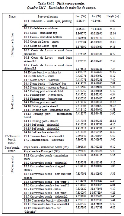
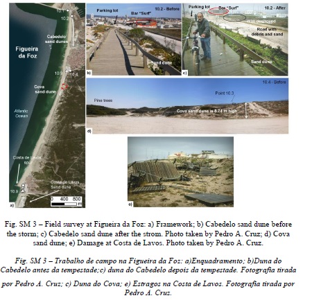
A field survey had been conducted at Cabedelo, Figueira da Foz (Point 10.1) before this storm on April 18th, 2012 (fig. 5b and SM 3b). Photos after the storm show that the waves overtopped the parking lot which is 5.67 m high (table SM i), inundating it and depositing sand and small boulders. It partially destroyed a wall near the road. The sand dune is 9.13 m high (point 10.2), and did not suffer significant damage.
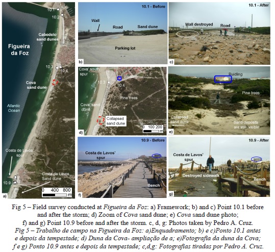
The Cova’ sand dune showed to be a natural barrier (fig. SM 3d, Point 10.3), reaching a height of 13.84 m. In 2013 part of the sand dune was showing signs of collapsing (fig. SM 2) being almost as the same level as Point 10.4 (5.10m). Although there were no structural damages on the area, the collapsed sand dune allowed the water to penetrate inland till the pine trees (fig. 5d, e).
The field survey conducted on Costa de Lavos on June 13th , 2013 shows that the sea front of Costa de Lavos (fig. 5f, Point 10.9) is located on high ground at 10.91 m, as is the south spur (Point 10.6, is 9.13 m). The storm did not damage any building or important infrastructure, but it completely destroyed the wooden sidewalk (figs. 5g and SM 3e) which is between 7.34 m and 8.77 m high (Points 10.7-9).
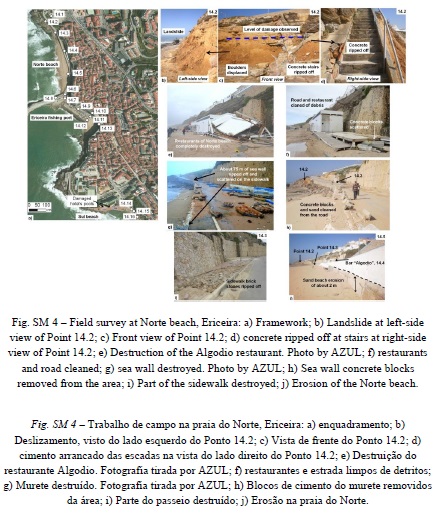
Ericeira (Point 14) was surveyed on several occasions, both before and after the storm. At the Norte beach, the sea waves moved several large boulders, caused a landslide and significant destruction on a concrete stair at Point 14.2, located at a height of 8.12 m (fig. SM 4 b, c, d). The waves also ripped away the concrete bricks of the sidewalk (fig. SM 4i), and completely destroyed all the beach bars (figs. 6b, c and SM 4e, f) except one that remained standing. The “algodio” bar is located about 7 m above mean sea level (Point 14.4). The first author measured an inundation depth of 2.7 m on the bar (fig. 6 c), giving a local run-up of 9.7 m. furthermore, the waves ripped away about 75 m of the concrete sea wall (fig. SM 4 g), which was deposited on the road. The cleaning operations started on January 7th and about 2 months later, on March 8th the road was clear of the debris (fig. SM 4 h). The beach was about 5 m high before the storm. However, figure SM 4j shows the erosion of the beach close to 2 m, and the access to the beach (Point 14.5) could not be used.
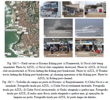
From the Norte beach, the waves propagated into the Ericeira fishing port. The naval club, located at a height of 5.19 m (Point 14.6), was completely destroyed (fig. SM 5 b, c), and on March 4th 2014 it was completely renovated (fig. SM 5 d). Two men trapped inside the club said the water level reached their necks (table I). The breakwater is 6.57 m high (Point 14.8), and the witnesses also reported that the waves passed over it. The difference in heights is 1.38 m which confirms the witnesses’ accounts. On the other hand, photos taken during the storm (fig. SM 5e) and in the evening of January 7th (fig. SM 5 f) show the waves hitting the breakwater and passing over it, validating the reports (table I). In addition, photos taken before and after the storm at the fishing port (fig. 6 d, e) showed a significant deposition of sand (fig. SM 5 g) that most likely originated from the Norte beach. The maximum inundation level was 4.51 m (Point 14.11) whereas the ground has a height of 3.9 m (Point 14.12), which shows that the breakwater had an important role in decreasing the waves’ impact on the fishing port because the inundation depth was 0.61 m only. since the fishermen’s warehouses are located on elevated ground (fig. SM 5 h) the waves did not cause significant damage inside the facilities, but the wave currents were strong enough to destroy several vessels, and ripping away a bench and the civil protection sign (fig. 6 e).
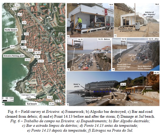
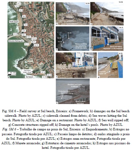
The Sul beach also suffered significant damage from the waves that ripped awaythe concrete floor and seawall, scattering debris and stones and leaving a hole on the ground (fig. SM 6 f and 6 b, f, g). Although by March 7th the sand and debris had been cleared from the sidewalk (fig. SM 6 c), damage was still visible. The waves hit the sidewalk, breaking and increasing significantly in height (fig. SM 6 d). Photos taken after the storm showed sand deposited on the sidewalk and broken windows in a restaurant (fig. SM 6 d, e). The sidewalk is located at about 6 m high (Point 14.14, Point 14.15, and Point 14.16); the windows are located about 2 m above the ground, giving a run-up of more than 6 m. The swimming pools of the hotel, at the same level as the sidewalk, were also very damaged (fig. SM 6 h). In addition, a fishing vessel was recovered from the sea. It was found around 8 m deep, about 2 km south of Ericeira and about 500 m from the beach, as reported by professional divers of NDivers.
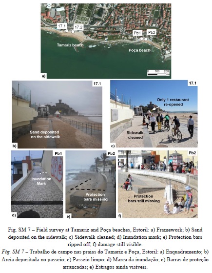
The January 7th survey showed a similar situation at Tamariz beach, Estoril (Point17), with sand deposited on the sidewalk and stones ripped away from it (fig. 7 b and SM 7 b). The witnesses and owners of the promenade’s restaurants and bars also reported damage (table I). On March 8th, 2014 everything was cleaned and repaired (fig. 7 c and SM 7 c), and one restaurant was already opened for business. Point 17.1 and 17.2 were 5.59 m and 5.00 m high, indicating the waves were at least 5.6 m high.
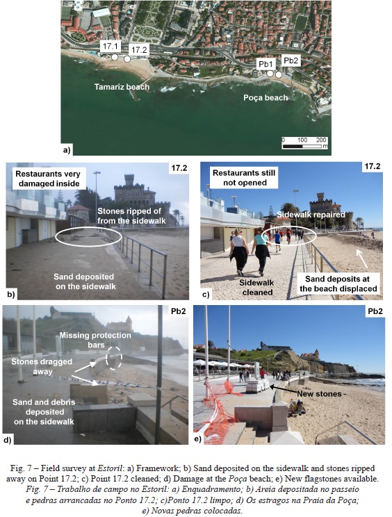
The media did not report any damage on the Poça beach, Estoril. Nevertheless, the first author found significant damage (fig. SM 7 d and 7 e). The inundation mark was at 6.12 m (Point Pb1). The sidewalk is 5.40 m high therefore the local inundation depth was 0.72 m, enough to scatter the sea walls stones on the sidewalk. On March 8th, 2014 the protection bars were still missing (fig. SM 7 f), but new stones were already available on site to rebuild the area.
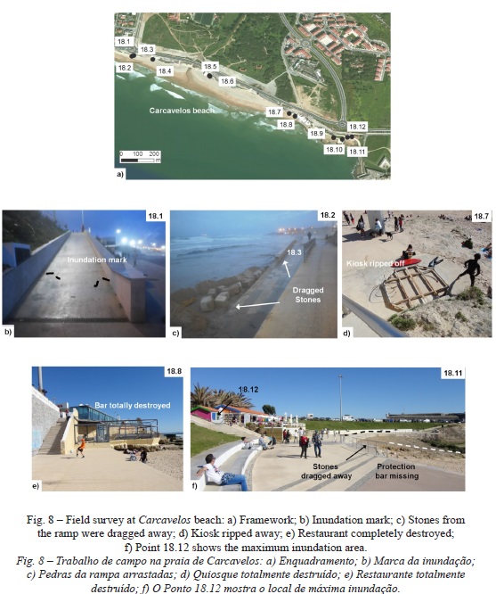
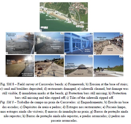
At Carcavelos (Point18), the inundation marks (fig. 8 b) left on the sidewalk showed that the waves reached a maximum of 5.56 m (Point 18.1). The stones were displaced (fig. 8 c) at a height of 3.85 m (Point 18.3). The bars, restaurants and surf school (Point 18.4), located at a height of 5.35 m, suffered significant damage (fig. SM 8d); in the same area there was sand erosion on the stairs and sand deposited on the ramp (fig. SM 8 b and c). On March 8th 2014, all shops were opened for business (fig. SM 8 e). The bar “surf” (Point 18.5) which is located at 6.43 m did not suffer any damage (fig. SM 8 f), and in the evening of January 7th it was opened for business. The sand reached 6.01 m (Point 18.5), showing the waves did not inundate the sidewalk. The most significant damage was observed at the eastern part of Carcavelos beach (fig. SM 8 d, e, f, g, h, i): a kiosk was torn apart (Point 18.7), being located at 4.19 m height, as well as the bar “fizz”, located at 4.25 m (Point 18.8). The protection bars were ripped away on several places (Points 18.9, 18.10 and 18.11) showing the waves were higher than 5.40 m. The bar “Moinho” suffered significant damage, despite being located at a height of 6.85 m (Point 18.12). On March 8th it was opened for business (fig. SM 8 ).
VI. DISCUSSION AND CONCLUSION
The storm was very well documented by the witnesses who posted news, articles, videos and photos on online archives. Most witnesses described one or two waves, around 6 - 9 m high (table I). In most coastal areas, the waves completely flooded the sand beaches, and overtopped the levees and breakwaters on the evening of January 6th and early morning of January 7th. These reports were validated by the Cascais tide gauge station. The flooded areas were not significantly large being restricted to the beaches, sea fronts, marinas and ports, and on some streets of the low coastal areas, including both commercial and residential buildings. A preliminary report revealed that the Hercules storm caused more than 16 million euros in damages (Pinto et al., 2014). The witnesses’ accounts also showed that the authorities were able to correctly forecast the storm and to warn the coastal populations in time. The immediate response of local authorities was commendable, not only in the emergency response but also in assessing damages and cleaning operations. However, the Portuguese population did not gain significant experience from previous disasters, and the “culture of risk” had not being completely assimilated. Hence, some locals and tourists did not take the warnings seriously, moved into dangerous areas too close to the shoreline to film or take photos of the event. As a consequence, several people were caught by the waves. Some were able to escape by themselves, but others needed assistance (about 20 people).
Previous involvement in hazard incidents is important in the risk perception (Queirós et al., 2007; Momani and salmi, 2012), and after this event the Portuguese population was more aware of coastal dangers. Nevertheless, a new incident happened on March 3rd, 2014 (sol, 2014) in which a 60 year old woman was caught by a wave at Poça beach (fig. SM 7) and died (Rodrigues et al., 2014). In order to prevent similar situations in the future it is necessary to develop strategies of spatial planning that involve the implementation of safety awareness, dissemination of disaster prevention measures and mitigation strategies to the general public. These strategies involve organization of drills and evacuation exercises (Queirós and Santos, 2013), as well as the distribution of informative pamphlets (Santos et al., 2013). At Ribeirinha, Pico Island, Azores, the beach structures will not be reconstructed on the same place because it is clearly unsafe (Carmo and Paiva, 2014). Most likely those structures will be rebuilt on higher ground.
Still, the Hercules storm showed the weaknesses of the coastal areas to a maritime extreme event, showing that coastal protections need serious evaluation and urgent mitigation actions are necessary. The problem of coastal erosion in Portugal has been addressed in the past (Paixão 2013, Trindade and Ramos-Pereira, 2013), but no practical solutions have been found yet. Although sand dunes offer a natural protection, they are not reinforced material. The construction of spurs and breakwaters offer some protection but other engineering solutions should be considered, e.g. all breakwaters and sea walls should be reinforced and elevated at least by 0.5 m.
The Hercules storm was characterized by long period waves, causing its behaviour on the coastline as “tsunami like”. This phenomenon is designated by scientific literature as meteotsunami or meteorological tsunami. Therefore, post-tsunami field survey techniques were used in order to study the impacts of this storm. The field survey confirmed the witnesses’ accounts of wave heights of 6 to 9 m and confirmed the deposition of sand reported by the witnesses. It showed scouring and erosion nearby those areas. The inundation depths were less than 1.0 m in most areas, being restricted to the sea fronts, marinas and ports. Photos taken before and after the storm allowed a better comprehension of the coastal impact of the storm. The field survey also showed that the Portuguese coastline has high ground nearby the beaches and ports allowing the users to escape safely and in time to higher ground.
ACKNOWLEDGMENTS
This study was supported by the Tsurima Project - Tsunami risk Management for spatial planning and civil protection (PtDC/CsGeO/118992/2010) funded by the foundation of science and technology (fCt), Portugal. The authors are very thankful to Mr. Pedro Agostinho Cruz and to Azul, for allowing the publication of the photos at Figueira da Foz and Ericeira. The authors would also like the thank Diver nelson Martins (NDivers) for providing useful information about an underwater recovery and Dr. Lourdes Bugalho (IPMA) for the support in the characterization of the synoptic situation associated to the Hercules storm. Finally, thanks are due to the anonymous referees that contributed to the improvement of this paper.
BIBLIOGRAPHY
AZUL (2014) Tempestade Hércules deixa danos materiais nas praias da Ericeira. Azul Ericeira Mag. (http://www.ericeiramag.pt/tempestade-Hercules-deixa-danos-materiais-nas-praias-da-ericeira/ ). Last access on January 7, 2014.
Bessa J, Valentim H (2014) Freguesias de Ovar sofrem com a violência do mar. Porto Canal online. (http://portocanal.sapo.pt/noticia/14405/ ). Last access on January 7, 2014. [ Links ]
Carmo C, Paiva M (2014) Ondas gigantes arrasam costa. Agência Lusa. Correio da Manhã online. (http://www.cmjornal.xl.pt/detalhe/noticias/nacional/sociedade/ondas-gigantes-arrasam-costa211217480 ). Last access on January 7, 2014.
Cruz P A (2014) Tempestade Hércules na margem Sul do Mondego. (http://pedrojoseagostinhodacruz.blogspot.pt/search?q=tempestade). Last access on January 7, 2014.
DC (2014) Mar agitado “lança pânico” na Figueira da Foz. Diário de Coimbra online. (http://diariocoimbra.pt/noticias/mar-agitado-lanca-panico-na-figueira-da-foz. Last access on January 7, 2014. [ Links ]
Fernandes A, Riberiro, J (2014) Mar invade marginal da Póvoa de Varzim e danifica estabelecimentos, Agência Lusa. Porto Canal online. (http://portocanal.sapo.pt/noticia/14341). Last access on January 7, 2014. [ Links ]
Fernandes D T, Eurico A, Andrade F (2014) Turistas espanhóis arrastados por onda na Madeira. Bom Dia Portugal 07/01/2014. RTP Notícias online (http://www.rtp.pt/noticias/index.php?article=707860&tm=8&layout=122&visual=61 ). Last access on January 7, 2014.
Ferreira H, Silva M (2014) Agitação do mar obriga à evacuação de escola primária em Gaia. Porto Canal online.( http://portocanal.sapo.pt/noticia/14399/).Last access on January 7, 2014. [ Links ]
JN (2014) Agitação marítima revela proteção da costa da Figueira da Foz construída há 50 anos. Jornal de Notícias online. (http://www.jn.pt/paginainicial/pais/concelho.aspx?Distrito=Coimbra&Concelho=Figueira%20da%20Foz&Option=Interior&content_id=3620060&page=-1). Last access on January 7, 2014. [ Links ]
Neves N, Nascimento P, Gadanha C (2014) Mau tempo impede pescadores açorianos de ir ao mar há uma semana. Bom Dia Portugal 07/01/2014. RTPonline (http://www.rtp.pt/noticias/index.php?article=707859&tm=8&layout=122&visual=61 ). Last access on January 7, 2014.
PC (2014a) Trabalhos de limpeza decorrem na foz do Douro e marginal continua fechada. Porto Canal online. (http://portocanal.sapo.pt/noticia/14384). Last access on January 7, 2014. [ Links ]
PC (2014b) Mar destruiu bares e escola de surf em Leça da Palmeira. Porto Canal online. (http://portocanal.sapo.pt/noticia/14406/ ). Last access on January 7, 2014. [ Links ]
PC (2014c) Agitação marítima destrói duas escolas de surf em Matosinhos. Porto Canal online. (http://portocanal.sapo.pt/noticia/14619/). Last access on January 9, 2014. [ Links ]
Ramalhinho J (2014) Praia Grande e Praia das Maçãs afectadas pelo mau tempo em Sintra. Antena 1. RTP online (http://www.rtp.pt/noticias/index.php?article=707733&tm=8&layout=123&visual=61). Last access on January 7, 2014.
Ribeiro A, Gomes P, Tomás S (2014) Ondas de oito metros devastam costa Norte. Bom Dia Portugal 06/01/2014. RTP online. (http://www.rtp.pt/noticias/index.php?article=707628&tm=8&layout=122&visual=61). Last access on January 7, 2014.
Rodrigues A L, Sousa e Silva H, Jorge P, Boa-Alma P, Brízido V (2014) Mulher de 60 anos foi arrastada por onda numa praia do Estoril. RTP online. (http://www.rtp.pt/noticias/index.php?article=721222&tm=8&layout=122&visual=61). Last access on March 17, 2014.
RS (2014a) Mau tempo: Praias de sagres com apoios de praia destruídos e lixo. Diário online Região Sul. Agência Lusa. (http://www.regiao-sul.pt/noticia.php?refnoticia=142566). Last access on January 7, 2014.
RS (2014b) Mau tempo: Situa ção da noite passada na Marina de Portimão foi “anormal”. Diário online Região Sul. Agência Lusa. (http://www.regiao-sul.pt/noticia.php?refnoticia=142563). Last access on January 7, 2014. [ Links ]
RTPN (2014a) Dois bares inundados em Espinho, barreiras seguram o mar em Paramos. Agência lusa. RTP online (http://www.rtp.pt/noticias/index.php?article=707738&tm=8&layout=121&visual=49). Last access on January 7, 2014.
RTPN (2014b) Temporal afetou diversas estruturas de apoio marítimo no Algarve. RTP online (http://www.rtp.pt/noticias/index.php?article=707812&tm=8&layout=122&visual=61). Last access on January 7, 2014.
RTPN (2014c) Quatro feridos e dezenas de carros arrastados por onda na Foz do Porto. Agencia Lusa. RTP online (http://www.rtp.pt/noticias/index.php?article=707725&tm=8&layout=121&visual=49). Last access on January 7, 2014.
RTPN (2014d) Madrugada calma depois de tempestade na segunda-feira dizem Autoridades. RTP online. (http://www.rtp.pt/noticias/index.php?article=707813&tm=8&layout=121&visual=49). Last access on January 7.
RTPN (2014e) Ondas na Foz do Porto podem repetir-se ao longo da noite. Agencia lusa. RTP online (http://www.rtp.pt/noticias/index.php?article=707732&tm=8&layout=121&visual=49). Last access on January 7, 2014.
RTPN (2014f) Um ferido ligeiro em Ovar por andar a “ver o panorama” no Furadouro. Agência Lusa. RTP online.(http://www.rtp.pt/noticias/index.php?article=707742&tm=8&layout=121&visual=49). Last access on January 7, 2014.
RTPN (2014g) Temporal afetou diversas estruturas de apoio marítimo no Algarve. RTP online. (http://www.rtp.pt/noticias/index.php?article=707812&tm=8&layout=122&visual=61 ). Last access on January 7, 2014.
SICN (2014a) Vários restaurantes e bares nas praias destruídos na marginal de Cascais. SIC Notícias online. (http://sicnoticias.sapo.pt/pais/2014-01-07-varios-restaurantes-e-bares-nas-praias-destruidos-na-marginal-de-cascais ). Last access on January 7, 2014. [ Links ]
SICN (2014b) Três restaurantes entre Ferragudo e Carvoeiro muito danificados pelas ondas. SIC Notícias online. http://sicnoticias.sapo.pt/pais/2014-01-07-tres-restaurantes-entre-ferragudo-e-carvoeiro-muito-danificados-pelas-ondas Last access on January 7, 2014. [ Links ]
SICN (2014c) Mar galgou paredão da Costa da Caparica. Lusa. SIC Not ícias online. (http://sicnoticias.sapo.pt/pais/2014/01/06/mar-galgou-paredao-da-costa-da-caparica ). Last Access on January 7, 2014.
Sol C P (2014) Mulher ferida com gravidade em praia do Estoril. Rádio Renascença online. (http://rr.sapo.pt/informacao_detalhe.aspx?fid=25&did=140940). Last access on March 17, 2014. [ Links ]
Sousa L (2014) Começou limpeza dos destro ços na praia do Tamariz. RTP online. (http://www.rtp.pt/noticias/index.php?article=707863&tm=8&layout=122&visual=61 ). Last access on January 7, 2014.
TVI24 (2014a) Carcavelos: proprietários de restaurantes contabilizam prejuízos. TVI24 online. (http://www.TVI24.iol.pt/503/sociedade/mau-tempo-onda-gigante—carcavelosprejuizos-TVI24/1525636-4071.html ). Last access on January 7, 2014.
TVI24 (2014b) Mau tempo faz “largos milhares de euros de prejuízos” em Sintra. TVI24 online. (http://www.tvi24.iol.pt/503/sociedade/mau-tempo-sintra-prejuizos-milhares-de-euros-basilio-horta-ps/1525624-4071.html). Last access on January 7, 2014. [ Links ]
TVI24 (2014c) Mau tempo: “elevados danos” em Matosinhos, diz autarquia. TVI24 online. (http://www.tvi24.iol.pt/503/sociedade/matosinhos-mar-agitacao-maritima-tempo-mau-tempo-TVI24/1525690-4071.html). Last access on January 7, 2014. [ Links ]
TVI24 (2014d) “Estou há 48 anos na Costa da Caparica e nunca vi coisa igual”. TVI24 online. (http://www.tvi24.iol.pt/503/sociedade/mau-tempo-onda-gigante--costa-caparica-barbas-TVI24/1525620-4071.html). Last access on January 7, 2014. [ Links ]
TVI24 (2014e) Dunas da Costa da Caparica afectadas pelo mau tempo. TVI24 online. (http://www.tvi24.iol.pt/503/sociedade/mau-tempo-caparica-costa-aviso-laranja-ondas-TVI24/1525497-4071.html). Last access on January 7, 2014. [ Links ]
TVI24 (2014f) Restaurante de Milfontes destruído com força das ondas. TVI24 online. (http://www.tvi24.iol.pt/503/sociedade/mau-tempo-onda-gigante--onda-gigante-porto-milfontes-restaurante-TVI24/1525587-4071.html). Last access on January 7, 2014. [ Links ]
TVI24 (2014g) Mar em Peniche danifica embarcações e interdita acesso à marina. TVI24 online. (http://www.tvi24.iol.pt/503/sociedade/mau-tempo-ondas-alerta-peniche-baleal-TVI24/1525446-4071.html). Last access on January 7, 2014. [ Links ]
TVI24 (2014i) Onda arrasta carros e corta estrada na Foz do Arelho. TVI24 online. (http://www.TVI24.iol.pt/503/sociedade/onda-foz-do-arelho-ondas-gigantes-alerta-proteccao-civil-carros/1525404-4071.html). Last access on January 7, 2014.
Received: March 2013: Accepted: January 2014.
APPENDIX A. SUPPLEMENTARY MATERIAL
Supplementary material related to this article can be found at http://revistas.rcaap.pt/finisterra/article/view/6468

